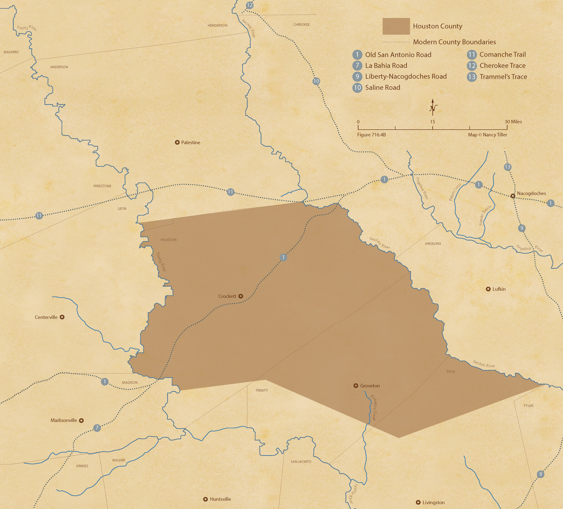
The Republic County of Houston. February 2, 1842
Figure No. 716.4 from 'A Boundary Atlas of Texas, 1821-1845' by Jim Tiller
-
Map/Doc
96181
-
Collection
Nancy and Jim Tiller Digital Collection
-
Object Dates
2020/1/1 (Creation Date)
-
People and Organizations
Jim Tiller (Author)
Nancy Tiller (Cartographer)
Gang Gong (GIS Professional)
-
Counties
Houston
-
Subjects
Atlas County Republic of Texas Texas Boundaries
-
Height x Width
19.7 x 21.8 inches
50.0 x 55.4 cm
-
Medium
digital image
-
Comments
To purchase a digital PDF copy of "A Boundary Atlas of Texas, 1821-1845" see 96437.
Part of: Nancy and Jim Tiller Digital Collection
Letter from Jesse Grimes Suggesting a Redefinition of the Boundary Between Harris and Montgomery Counties, April 30, 1838

Print $20.00
Letter from Jesse Grimes Suggesting a Redefinition of the Boundary Between Harris and Montgomery Counties, April 30, 1838
2020
Size 15.4 x 21.7 inches
Map/Doc 96381
The Republic County of Goliad. Proposed, Late Fall 1837

Print $20.00
The Republic County of Goliad. Proposed, Late Fall 1837
2020
Size 15.1 x 21.7 inches
Map/Doc 96147
The Republic County of Fort Bend. February 4, 1841

Print $20.00
The Republic County of Fort Bend. February 4, 1841
2020
Size 14.7 x 21.6 inches
Map/Doc 96141
The Republic County of Jackson. 1840

Print $20.00
The Republic County of Jackson. 1840
2020
Size 15.6 x 21.8 inches
Map/Doc 96186
A Boundary Atlas of Texas, 1821-1845

Digital $50.00
A Boundary Atlas of Texas, 1821-1845
2020
Map/Doc 96437
From Citizens Living in What Was to Become Fannin County for the Creation of a New County (Unnamed), Undated

Print $20.00
From Citizens Living in What Was to Become Fannin County for the Creation of a New County (Unnamed), Undated
2020
Size 17.6 x 21.7 inches
Map/Doc 96400
The Pringle and Grieve Colony. November 1, 1843

Print $20.00
The Pringle and Grieve Colony. November 1, 1843
2020
Size 23.0 x 17.7 inches
Map/Doc 96371
From Citizens of Nacogdoches County Living East of the Trinity River and Along the Old San Antonio Road for the Creation of a New County (Unnamed), April 22, 1837

Print $20.00
From Citizens of Nacogdoches County Living East of the Trinity River and Along the Old San Antonio Road for the Creation of a New County (Unnamed), April 22, 1837
2020
Size 19.9 x 21.7 inches
Map/Doc 96374
From Citizens of Nacogdoches County for the Creation of a New Judicial County (Unnamed), November 16, 1840

Print $20.00
From Citizens of Nacogdoches County for the Creation of a New Judicial County (Unnamed), November 16, 1840
2020
Size 14.6 x 21.7 inches
Map/Doc 96409
The Judicial District/County of Lavaca. Abolished, Spring 1842

Print $20.00
The Judicial District/County of Lavaca. Abolished, Spring 1842
2020
Size 14.6 x 21.7 inches
Map/Doc 96332
The Republic County of Bexar. November 28, 1839

Print $20.00
The Republic County of Bexar. November 28, 1839
2020
Size 14.8 x 21.1 inches
Map/Doc 96097
The Republic County of Matagorda. 1840

Print $20.00
The Republic County of Matagorda. 1840
2020
Size 21.0 x 21.7 inches
Map/Doc 96218
You may also like
Bell County Sketch File 29

Print $4.00
- Digital $50.00
Bell County Sketch File 29
1874
Size 13.1 x 8.1 inches
Map/Doc 14439
Right of Way and Track Map, Dayton-Goose Creek Ry. Co., Station 0+00 to Station 190+00

Print $40.00
- Digital $50.00
Right of Way and Track Map, Dayton-Goose Creek Ry. Co., Station 0+00 to Station 190+00
1917
Size 24.8 x 56.6 inches
Map/Doc 64365
Loving County

Print $20.00
- Digital $50.00
Loving County
1889
Size 24.6 x 19.6 inches
Map/Doc 91385
Culberson County Rolled Sketch 54

Print $40.00
- Digital $50.00
Culberson County Rolled Sketch 54
1968
Size 59.0 x 29.4 inches
Map/Doc 10300
[Plat Showing Colorado, Upshur & Travis County School Land and Surrounding Area in Baylor & Throckmorton Counties, Texas]
![75790, [Plat Showing Colorado, Upshur & Travis County School Land and Surrounding Area in Baylor & Throckmorton Counties, Texas], Maddox Collection](https://historictexasmaps.com/wmedia_w700/maps/75790.tif.jpg)
Print $20.00
- Digital $50.00
[Plat Showing Colorado, Upshur & Travis County School Land and Surrounding Area in Baylor & Throckmorton Counties, Texas]
1889
Size 15.8 x 20.5 inches
Map/Doc 75790
Childress County

Print $20.00
- Digital $50.00
Childress County
1892
Size 36.2 x 27.1 inches
Map/Doc 3392
Flight Mission No. DCL-5C, Frame 69, Kenedy County

Print $20.00
- Digital $50.00
Flight Mission No. DCL-5C, Frame 69, Kenedy County
1943
Size 18.5 x 22.3 inches
Map/Doc 85852
The Texas Co-Ordinate System, Title 86 Article 5300A.

Print $20.00
- Digital $50.00
The Texas Co-Ordinate System, Title 86 Article 5300A.
Size 30.8 x 28.4 inches
Map/Doc 92824
General Highway Map, McLennan County, Texas

Print $20.00
General Highway Map, McLennan County, Texas
1940
Size 18.3 x 24.6 inches
Map/Doc 79191
J No. 8 - Reconnaissance of the Harbors of Santa Cruz, San Simeon, Coxo, and San Luis Obispo, California

Print $20.00
- Digital $50.00
J No. 8 - Reconnaissance of the Harbors of Santa Cruz, San Simeon, Coxo, and San Luis Obispo, California
1852
Size 19.2 x 16.6 inches
Map/Doc 97235
Flight Mission No. CRK-7P, Frame 27, Refugio County

Print $20.00
- Digital $50.00
Flight Mission No. CRK-7P, Frame 27, Refugio County
1956
Size 18.3 x 22.1 inches
Map/Doc 86947
Edwards County Working Sketch 9

Print $20.00
- Digital $50.00
Edwards County Working Sketch 9
1920
Size 22.2 x 34.7 inches
Map/Doc 68885