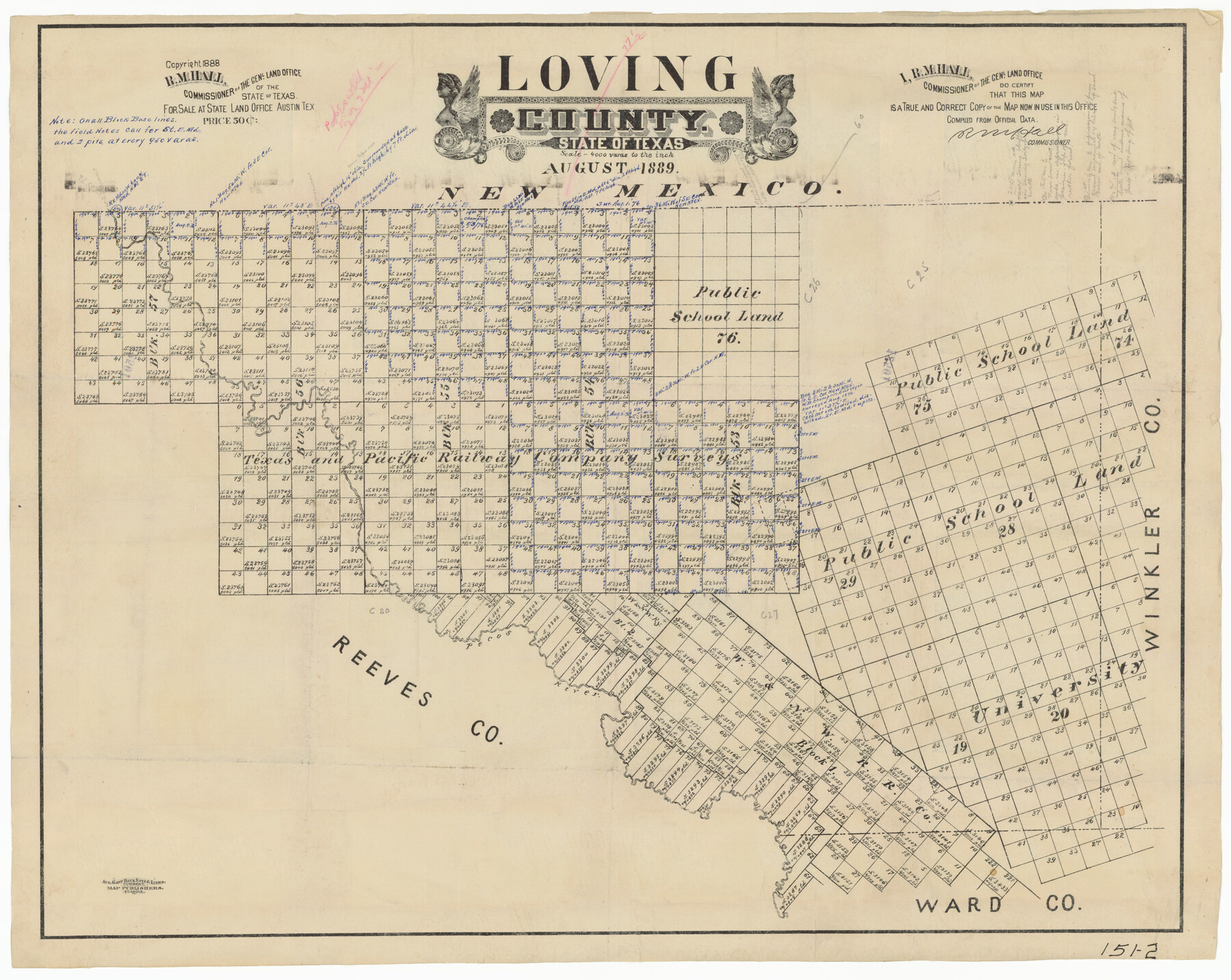
Loving County
151-2
-
Map/Doc
91385
-
Collection
Twichell Survey Records
-
Object Dates
8/1889 (Creation Date)
-
Counties
Loving
-
Subjects
County
-
Height x Width
24.6 x 19.6 inches
62.5 x 49.8 cm
Part of: Twichell Survey Records
[Sketch of parts of Blocks M6, 2Z and B5]
![91934, [Sketch of parts of Blocks M6, 2Z and B5], Twichell Survey Records](https://historictexasmaps.com/wmedia_w700/maps/91934-1.tif.jpg)
Print $20.00
- Digital $50.00
[Sketch of parts of Blocks M6, 2Z and B5]
1917
Size 43.1 x 20.9 inches
Map/Doc 91934
Map of Parts of Dawson and Borden Counties

Print $20.00
- Digital $50.00
Map of Parts of Dawson and Borden Counties
Size 23.0 x 17.7 inches
Map/Doc 90627
[Block M-23 and vicinity]
![91148, [Block M-23 and vicinity], Twichell Survey Records](https://historictexasmaps.com/wmedia_w700/maps/91148-1.tif.jpg)
Print $3.00
- Digital $50.00
[Block M-23 and vicinity]
Size 11.1 x 13.6 inches
Map/Doc 91148
Double Lakes No. 1 T-Ranch Lynn County, Texas

Print $20.00
- Digital $50.00
Double Lakes No. 1 T-Ranch Lynn County, Texas
Size 36.8 x 31.8 inches
Map/Doc 93216
[Area Surrounding Lee County School Land]
![90887, [Area Surrounding Lee County School Land], Twichell Survey Records](https://historictexasmaps.com/wmedia_w700/maps/90887-1.tif.jpg)
Print $20.00
- Digital $50.00
[Area Surrounding Lee County School Land]
1907
Size 13.9 x 19.2 inches
Map/Doc 90887
General Highway Map, Crosby County, Texas

Print $20.00
- Digital $50.00
General Highway Map, Crosby County, Texas
1950
Size 25.5 x 18.8 inches
Map/Doc 92597
[Block M24, Surveys 1-8 and vicinity]
![91231, [Block M24, Surveys 1-8 and vicinity], Twichell Survey Records](https://historictexasmaps.com/wmedia_w700/maps/91231-1.tif.jpg)
Print $20.00
- Digital $50.00
[Block M24, Surveys 1-8 and vicinity]
1909
Size 16.4 x 18.2 inches
Map/Doc 91231
France Baker Farm

Print $3.00
- Digital $50.00
France Baker Farm
Size 9.5 x 12.0 inches
Map/Doc 92332
[T. & P. Blocks 33 and 34, Townships 4N and 5N]
![90625, [T. & P. Blocks 33 and 34, Townships 4N and 5N], Twichell Survey Records](https://historictexasmaps.com/wmedia_w700/maps/90625-1.tif.jpg)
Print $20.00
- Digital $50.00
[T. & P. Blocks 33 and 34, Townships 4N and 5N]
Size 14.4 x 17.7 inches
Map/Doc 90625
![91292, [League 321], Twichell Survey Records](https://historictexasmaps.com/wmedia_w700/maps/91292-1.tif.jpg)
[Sketch showing elevation between College Heights and Miller-Stevens Subdivision along Lincoln Ave.]
![92881, [Sketch showing elevation between College Heights and Miller-Stevens Subdivision along Lincoln Ave.], Twichell Survey Records](https://historictexasmaps.com/wmedia_w700/maps/92881-1.tif.jpg)
Print $20.00
- Digital $50.00
[Sketch showing elevation between College Heights and Miller-Stevens Subdivision along Lincoln Ave.]
Size 15.7 x 13.8 inches
Map/Doc 92881
N. C. Payne Land in Lamb and Hale Counties]
![91060, N. C. Payne Land in Lamb and Hale Counties], Twichell Survey Records](https://historictexasmaps.com/wmedia_w700/maps/91060-1.tif.jpg)
Print $20.00
- Digital $50.00
N. C. Payne Land in Lamb and Hale Counties]
Size 18.6 x 23.9 inches
Map/Doc 91060
You may also like
Map Showing Resurvey of Capitol Leagues, Bailey, Lamb & Castro Co's.

Print $20.00
- Digital $50.00
Map Showing Resurvey of Capitol Leagues, Bailey, Lamb & Castro Co's.
1918
Size 17.3 x 42.5 inches
Map/Doc 1758
Stephens County Working Sketch 10

Print $40.00
- Digital $50.00
Stephens County Working Sketch 10
1921
Size 36.1 x 64.1 inches
Map/Doc 63953
Texas City Channel, Texas, Channel and Turning Basin Dredging - Sheet 1

Print $20.00
- Digital $50.00
Texas City Channel, Texas, Channel and Turning Basin Dredging - Sheet 1
1958
Size 29.3 x 40.8 inches
Map/Doc 61831
Jasper County Working Sketch 13

Print $20.00
- Digital $50.00
Jasper County Working Sketch 13
1920
Size 24.3 x 17.1 inches
Map/Doc 66475
[Blocks T1, T2, T3, and Vicinity]
![90983, [Blocks T1, T2, T3, and Vicinity], Twichell Survey Records](https://historictexasmaps.com/wmedia_w700/maps/90983-1.tif.jpg)
Print $20.00
- Digital $50.00
[Blocks T1, T2, T3, and Vicinity]
Size 30.3 x 33.6 inches
Map/Doc 90983
Coast Chart No. 210 Aransas Pass and Corpus Christi Bay with the coast to latitude 27° 12' Texas

Print $20.00
- Digital $50.00
Coast Chart No. 210 Aransas Pass and Corpus Christi Bay with the coast to latitude 27° 12' Texas
1913
Size 27.4 x 18.3 inches
Map/Doc 72797
A Geological Map of the United States

Print $20.00
A Geological Map of the United States
Size 10.2 x 15.9 inches
Map/Doc 95281
Lampasas County Working Sketch 14

Print $20.00
- Digital $50.00
Lampasas County Working Sketch 14
1974
Size 23.4 x 21.8 inches
Map/Doc 70291

General Highway Map, Irion County, Texas

Print $20.00
General Highway Map, Irion County, Texas
1940
Size 18.3 x 24.8 inches
Map/Doc 79138
Garza County Sketch File 25a

Print $14.00
- Digital $50.00
Garza County Sketch File 25a
Size 11.4 x 8.8 inches
Map/Doc 24088
Chambers County Sketch File 22

Print $8.00
- Digital $50.00
Chambers County Sketch File 22
Size 12.2 x 7.6 inches
Map/Doc 17594