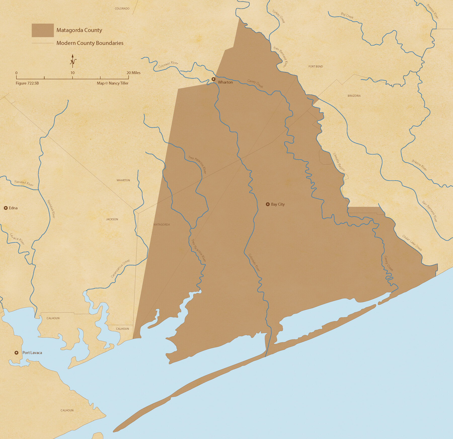
The Republic County of Matagorda. 1840
Figure No. 722.5 from 'A Boundary Atlas of Texas, 1821-1845' by Jim Tiller
-
Map/Doc
96218
-
Collection
Nancy and Jim Tiller Digital Collection
-
Object Dates
2020/1/1 (Creation Date)
-
People and Organizations
Jim Tiller (Author)
Nancy Tiller (Cartographer)
Gang Gong (GIS Professional)
-
Counties
Matagorda
-
Subjects
Atlas County Republic of Texas Texas Boundaries
-
Height x Width
21.0 x 21.7 inches
53.3 x 55.1 cm
-
Medium
digital image
-
Comments
To purchase a digital PDF copy of "A Boundary Atlas of Texas, 1821-1845" see 96437.
Part of: Nancy and Jim Tiller Digital Collection
The Republic County of Rusk. December 31, 1844

Print $20.00
The Republic County of Rusk. December 31, 1844
2020
Size 19.1 x 21.7 inches
Map/Doc 96266
The League Lines, Coastal and Border Reserves, with Surveys

Print $20.00
The League Lines, Coastal and Border Reserves, with Surveys
2020
Size 20.1 x 21.7 inches
Map/Doc 96426
The Judicial District/County of Lavaca. Abolished, Spring 1842

Print $20.00
The Judicial District/County of Lavaca. Abolished, Spring 1842
2020
Size 14.6 x 21.7 inches
Map/Doc 96332
The Republic County of Fannin. Created, December 14, 1837

Print $20.00
The Republic County of Fannin. Created, December 14, 1837
2020
Size 15.0 x 21.7 inches
Map/Doc 96128
The Republic County of Red River. Boundaries Defined, December 18, 1837

Print $20.00
The Republic County of Red River. Boundaries Defined, December 18, 1837
2020
Size 17.4 x 21.7 inches
Map/Doc 96251
The Mexican Department of Nacogdoches. On the Eve of Texas Independence, 1836

Print $20.00
The Mexican Department of Nacogdoches. On the Eve of Texas Independence, 1836
2020
Size 18.4 x 21.7 inches
Map/Doc 95974
The Fisher-Miller Colony. September 1, 1843

Print $20.00
The Fisher-Miller Colony. September 1, 1843
2020
Size 13.8 x 21.7 inches
Map/Doc 96359
The Republic County of Galveston. December 16, 1839

Print $20.00
The Republic County of Galveston. December 16, 1839
2020
Size 14.7 x 21.9 inches
Map/Doc 96144
Leftwich Empresario Colony. April 15, 1825

Print $20.00
Leftwich Empresario Colony. April 15, 1825
2020
Size 19.5 x 21.7 inches
Map/Doc 95997
The Republic County of Victoria. Proposed, Late Fall 1837-September 18, 1838

Print $20.00
The Republic County of Victoria. Proposed, Late Fall 1837-September 18, 1838
2020
Size 22.5 x 21.7 inches
Map/Doc 96295
The Republic County of Bowie. January 16, 1843

Print $20.00
The Republic County of Bowie. January 16, 1843
2020
Size 19.5 x 21.7 inches
Map/Doc 96106
The Republic County of Nacogdoches. Proposed, Late Fall 1837-January 1, 1838

Print $20.00
The Republic County of Nacogdoches. Proposed, Late Fall 1837-January 1, 1838
2020
Size 17.8 x 21.7 inches
Map/Doc 96243
You may also like
Texas, Corpus Christi Bay, Red Fish Bay to Nueces Bay

Print $40.00
- Digital $50.00
Texas, Corpus Christi Bay, Red Fish Bay to Nueces Bay
1934
Size 31.8 x 48.3 inches
Map/Doc 73459
[Blocks B, T, and 1]
![90972, [Blocks B, T, and 1], Twichell Survey Records](https://historictexasmaps.com/wmedia_w700/maps/90972-1.tif.jpg)
Print $2.00
- Digital $50.00
[Blocks B, T, and 1]
Size 9.2 x 13.7 inches
Map/Doc 90972
Young County Sketch File 5

Print $40.00
- Digital $50.00
Young County Sketch File 5
1855
Size 12.8 x 15.6 inches
Map/Doc 49662
Controlled Mosaic by Jack Amman Photogrammetric Engineers, Inc - Sheet 26

Print $20.00
- Digital $50.00
Controlled Mosaic by Jack Amman Photogrammetric Engineers, Inc - Sheet 26
1954
Size 20.0 x 24.0 inches
Map/Doc 83477
Stonewall County Sketch File 17

Print $6.00
- Digital $50.00
Stonewall County Sketch File 17
1902
Size 16.5 x 10.6 inches
Map/Doc 37274
San Patricio County Rolled Sketch 42

Print $20.00
- Digital $50.00
San Patricio County Rolled Sketch 42
Size 18.6 x 37.3 inches
Map/Doc 7728

Flight Mission No. BRA-7M, Frame 31, Jefferson County

Print $20.00
- Digital $50.00
Flight Mission No. BRA-7M, Frame 31, Jefferson County
1953
Size 18.5 x 22.3 inches
Map/Doc 85482
Presidio County Working Sketch 18

Print $20.00
- Digital $50.00
Presidio County Working Sketch 18
1943
Size 26.0 x 25.4 inches
Map/Doc 71694
San Augustine County Working Sketch 9

Print $20.00
- Digital $50.00
San Augustine County Working Sketch 9
1935
Size 41.2 x 39.7 inches
Map/Doc 63696
General Highway Map, Waller County, Texas

Print $20.00
General Highway Map, Waller County, Texas
1939
Size 25.1 x 18.5 inches
Map/Doc 79270
[Gunter & Munson, Maddox Bros. & Anderson Block F] / [PSL Block B19]
![91852, [Gunter & Munson, Maddox Bros. & Anderson Block F] / [PSL Block B19], Twichell Survey Records](https://historictexasmaps.com/wmedia_w700/maps/91852-1.tif.jpg)
Print $20.00
- Digital $50.00
[Gunter & Munson, Maddox Bros. & Anderson Block F] / [PSL Block B19]
Size 20.1 x 18.6 inches
Map/Doc 91852