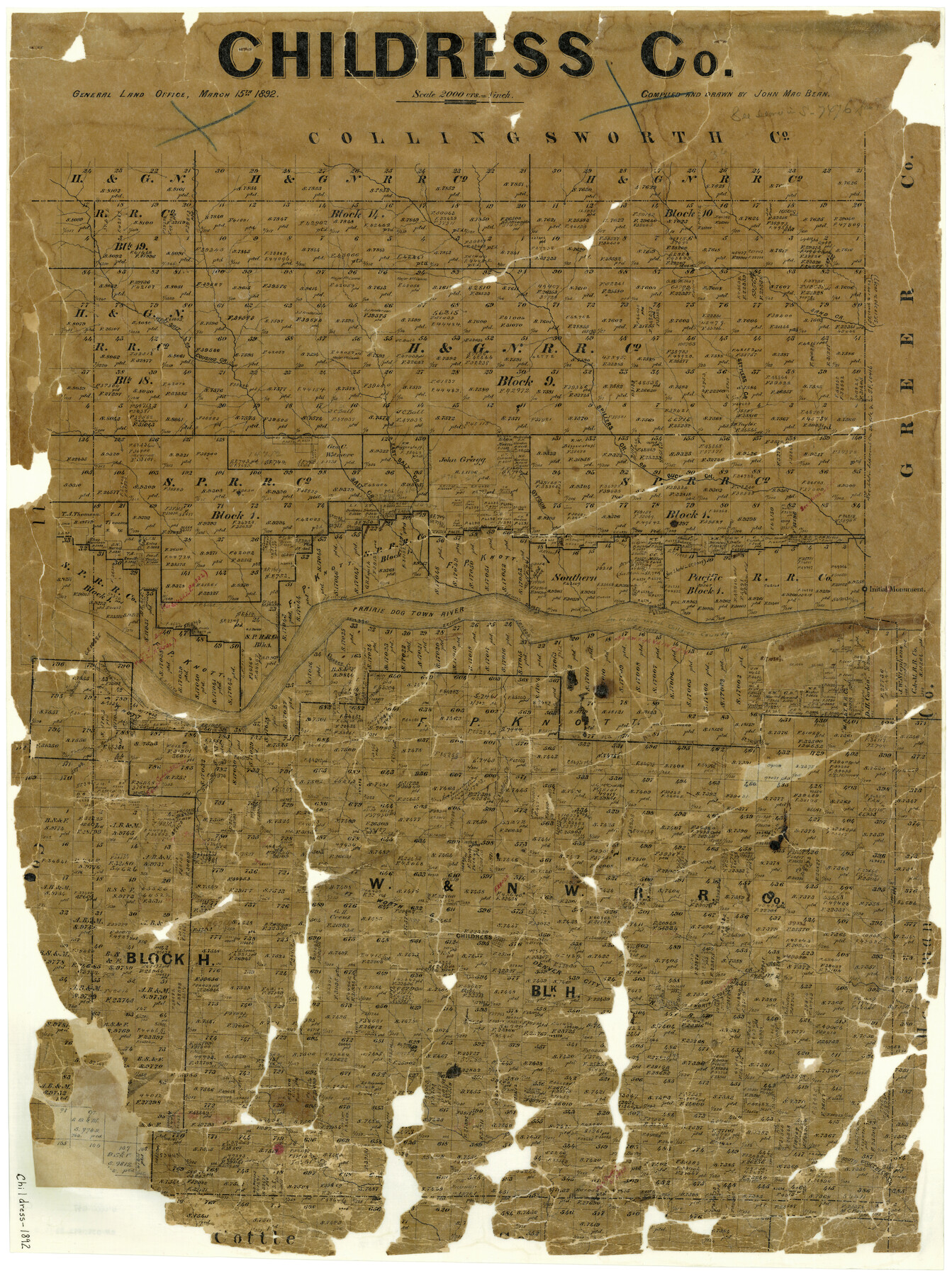
Childress County
-
Map/Doc
3392
-
Collection
General Map Collection
-
Object Dates
3/15/1892 (Creation Date)
-
People and Organizations
John MacBean (Draftsman)
-
Counties
Childress
-
Subjects
County
-
Height x Width
36.2 x 27.1 inches
92.0 x 68.8 cm
-
Features
Mountain Creek
South Groesbeck Creek
Shore's Creek
North Groesbeck Creek
FW&DC
Childress
Conklins' Creek
Baylor Creek
Rustlers Creek
Thornton's Creek
Sand Creek
Prairie Dog Town River
Gassey Creek
Gypsum Creek
Buck Creek
East Salt Creek
Spillers Creek
Old Settlers Creek
Cousins Creek
West Salt Creek
Part of: General Map Collection
Jefferson County Rolled Sketch 37

Print $20.00
- Digital $50.00
Jefferson County Rolled Sketch 37
1957
Size 36.4 x 30.1 inches
Map/Doc 6396
Flight Mission No. DAH-17M, Frame 27, Orange County

Print $20.00
- Digital $50.00
Flight Mission No. DAH-17M, Frame 27, Orange County
1953
Size 18.6 x 22.3 inches
Map/Doc 86890
Rio Grande, Mercedes and La Feria Sheet

Print $20.00
- Digital $50.00
Rio Grande, Mercedes and La Feria Sheet
1937
Size 37.3 x 37.2 inches
Map/Doc 65126
Travis County Appraisal District Plat Map 2_2512

Print $20.00
- Digital $50.00
Travis County Appraisal District Plat Map 2_2512
1938
Size 21.5 x 26.5 inches
Map/Doc 94216
Shelby County Sketch File 7

Print $4.00
- Digital $50.00
Shelby County Sketch File 7
1855
Size 8.9 x 13.3 inches
Map/Doc 36605
[Gulf Colorado & Santa Fe from 2178+36.0 to 3901+06.2]
![64698, [Gulf Colorado & Santa Fe from 2178+36.0 to 3901+06.2], General Map Collection](https://historictexasmaps.com/wmedia_w700/maps/64698.tif.jpg)
Print $40.00
- Digital $50.00
[Gulf Colorado & Santa Fe from 2178+36.0 to 3901+06.2]
Size 123.0 x 32.2 inches
Map/Doc 64698
Haskell County Working Sketch 5

Print $20.00
- Digital $50.00
Haskell County Working Sketch 5
1945
Size 22.2 x 37.2 inches
Map/Doc 66063
Key to Photo Index Sheets of Texas Coast Portion

Print $20.00
- Digital $50.00
Key to Photo Index Sheets of Texas Coast Portion
1954
Size 20.0 x 24.0 inches
Map/Doc 83436
Flight Mission No. BRA-8M, Frame 133, Jefferson County

Print $20.00
- Digital $50.00
Flight Mission No. BRA-8M, Frame 133, Jefferson County
1953
Size 18.7 x 22.3 inches
Map/Doc 85629
Culberson County Sketch File 14

Print $28.00
- Digital $50.00
Culberson County Sketch File 14
1928
Size 13.3 x 8.0 inches
Map/Doc 20176
Uvalde County Working Sketch 54

Print $20.00
- Digital $50.00
Uvalde County Working Sketch 54
1983
Size 39.6 x 32.3 inches
Map/Doc 72124
Map of Taylor, Bastrop & Houston Railroad in Williamson, Travis, & Bastrop Counties, Texas

Print $20.00
- Digital $50.00
Map of Taylor, Bastrop & Houston Railroad in Williamson, Travis, & Bastrop Counties, Texas
1887
Size 26.3 x 17.8 inches
Map/Doc 65468
You may also like
[River Meander along Jas. Tobin Survey and others]
![89814, [River Meander along Jas. Tobin Survey and others], Twichell Survey Records](https://historictexasmaps.com/wmedia_w700/maps/89814-1.tif.jpg)
Print $40.00
- Digital $50.00
[River Meander along Jas. Tobin Survey and others]
Size 73.6 x 43.9 inches
Map/Doc 89814
Flight Mission No. DQN-1K, Frame 122, Calhoun County

Print $20.00
- Digital $50.00
Flight Mission No. DQN-1K, Frame 122, Calhoun County
1953
Size 18.5 x 22.2 inches
Map/Doc 84188
Map of the L.I.T. Ranche situated in the Panhandle of Texas the property of the Prairie Cattle Co. L'd

Print $20.00
- Digital $50.00
Map of the L.I.T. Ranche situated in the Panhandle of Texas the property of the Prairie Cattle Co. L'd
1989
Size 21.0 x 12.6 inches
Map/Doc 2483
Maps of Gulf Intracoastal Waterway, Texas - Sabine River to the Rio Grande and connecting waterways including ship channels

Print $20.00
- Digital $50.00
Maps of Gulf Intracoastal Waterway, Texas - Sabine River to the Rio Grande and connecting waterways including ship channels
1966
Size 14.6 x 22.2 inches
Map/Doc 61975
Anderson County Working Sketch 13

Print $20.00
- Digital $50.00
Anderson County Working Sketch 13
1930
Size 34.0 x 21.9 inches
Map/Doc 67013
Wood County Sketch File 10

Print $12.00
- Digital $50.00
Wood County Sketch File 10
1850
Size 8.3 x 12.8 inches
Map/Doc 40658
Brazos County Working Sketch 2

Print $20.00
- Digital $50.00
Brazos County Working Sketch 2
1950
Size 31.9 x 36.0 inches
Map/Doc 67477
Brewster County Rolled Sketch 43

Print $40.00
- Digital $50.00
Brewster County Rolled Sketch 43
1913
Size 38.6 x 63.8 inches
Map/Doc 8476
Dickens County Rolled Sketch GW

Print $20.00
- Digital $50.00
Dickens County Rolled Sketch GW
1908
Size 31.6 x 25.2 inches
Map/Doc 5711
Blanco County Sketch File 28

Print $40.00
- Digital $50.00
Blanco County Sketch File 28
1888
Size 13.8 x 13.2 inches
Map/Doc 14623
Reeves County Rolled Sketch 10

Print $20.00
- Digital $50.00
Reeves County Rolled Sketch 10
Size 22.4 x 42.0 inches
Map/Doc 7480
Potter County Sketch File 5

Print $20.00
- Digital $50.00
Potter County Sketch File 5
1890
Size 14.1 x 8.8 inches
Map/Doc 34387