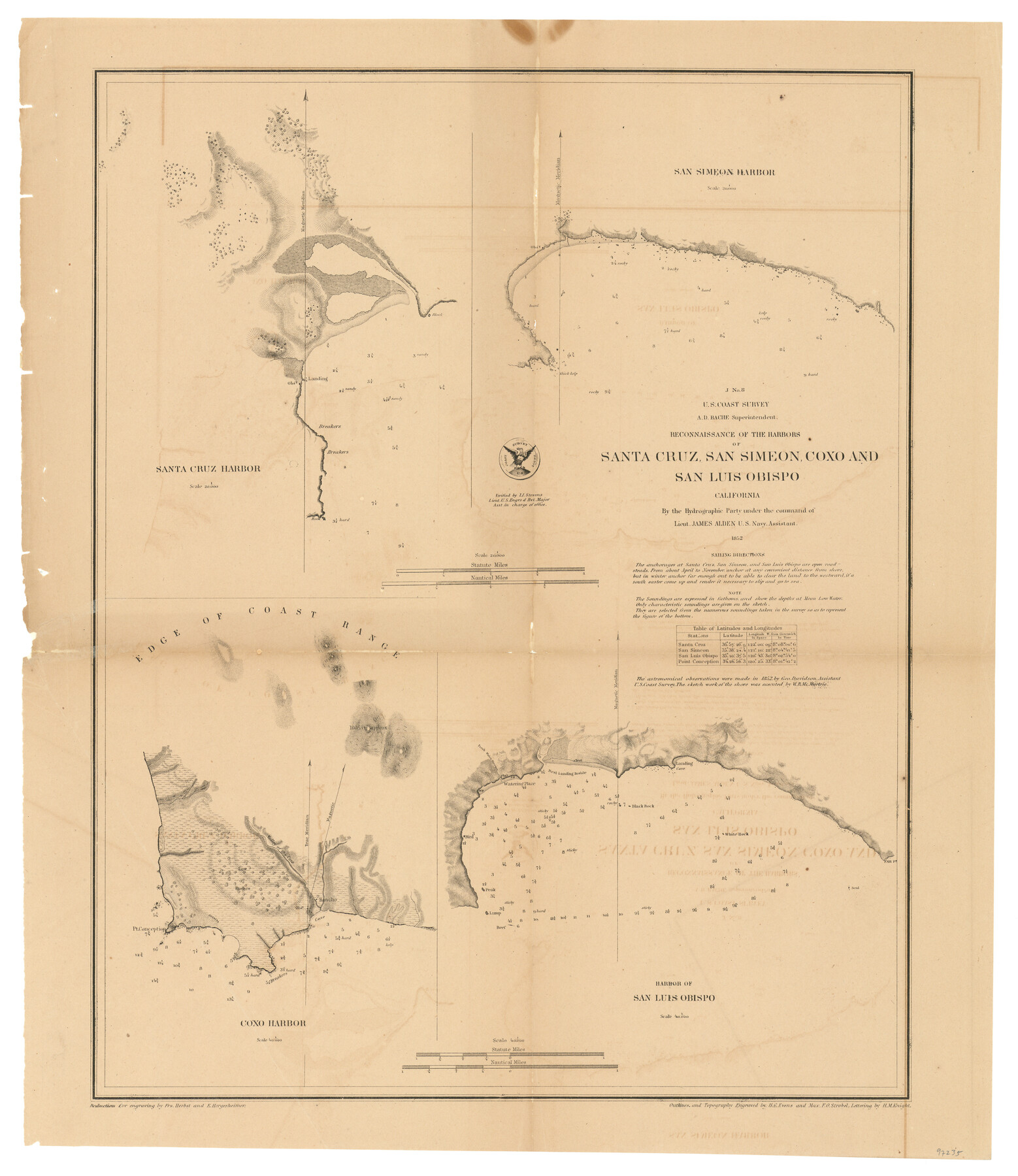
J No. 8 - Reconnaissance of the Harbors of Santa Cruz, San Simeon, Coxo, and San Luis Obispo, California
-
Map/Doc
97235
-
Collection
General Map Collection
-
Object Dates
1852 (Creation Date)
-
People and Organizations
A.D. Bache (Superintendent)
James Alden (Surveyor/Engineer)
I.I. Stevens (Surveyor/Engineer)
U.S. Coast Survey (Publisher)
-
Subjects
Coastal
-
Height x Width
19.2 x 16.6 inches
48.8 x 42.2 cm
-
Comments
Sketch from the book "Report of the Superintendent of the Coast Survey Showing the Progress of the Survey in the year 1852" (81738)
Related maps
Report of the Superintendent of the Coast Survey showing the progress of the survey during the year 1852

Report of the Superintendent of the Coast Survey showing the progress of the survey during the year 1852
1853
Map/Doc 81738
Part of: General Map Collection
Young County Sketch File 22

Print $20.00
- Digital $50.00
Young County Sketch File 22
1957
Size 22.9 x 19.8 inches
Map/Doc 12716
Llano County Sketch File 20

Print $4.00
- Digital $50.00
Llano County Sketch File 20
1873
Size 12.6 x 8.2 inches
Map/Doc 30405
Hutchinson County Rolled Sketch 43

Print $40.00
- Digital $50.00
Hutchinson County Rolled Sketch 43
1992
Size 40.5 x 49.4 inches
Map/Doc 6316
Fractional Township No. 7 South Range No. 6 East of the Indian Meridian, Indian Territory

Print $20.00
- Digital $50.00
Fractional Township No. 7 South Range No. 6 East of the Indian Meridian, Indian Territory
1898
Size 19.2 x 24.3 inches
Map/Doc 75211
Current Miscellaneous File 40

Print $10.00
- Digital $50.00
Current Miscellaneous File 40
Size 14.2 x 8.7 inches
Map/Doc 73972
Map of Henderson County

Print $40.00
- Digital $50.00
Map of Henderson County
1897
Size 28.9 x 58.9 inches
Map/Doc 66860
[Sketch for Mineral Application 24072, San Jacinto River]
![65588, [Sketch for Mineral Application 24072, San Jacinto River], General Map Collection](https://historictexasmaps.com/wmedia_w700/maps/65588.tif.jpg)
Print $20.00
- Digital $50.00
[Sketch for Mineral Application 24072, San Jacinto River]
1929
Size 19.6 x 13.7 inches
Map/Doc 65588
[Sketch for Mineral Application 27669 - Trinity River, Frank R. Graves]
![2856, [Sketch for Mineral Application 27669 - Trinity River, Frank R. Graves], General Map Collection](https://historictexasmaps.com/wmedia_w700/maps/2856-1.tif.jpg)
Print $20.00
- Digital $50.00
[Sketch for Mineral Application 27669 - Trinity River, Frank R. Graves]
1934
Size 24.9 x 36.0 inches
Map/Doc 2856
Outer Continental Shelf Leasing Maps (Louisiana Offshore Operations)

Print $20.00
- Digital $50.00
Outer Continental Shelf Leasing Maps (Louisiana Offshore Operations)
1954
Size 18.2 x 16.0 inches
Map/Doc 76105
Galveston County Sketch File 34

Print $20.00
- Digital $50.00
Galveston County Sketch File 34
1934
Size 11.5 x 20.1 inches
Map/Doc 11536
Flight Mission No. DIX-6P, Frame 185, Aransas County

Print $20.00
- Digital $50.00
Flight Mission No. DIX-6P, Frame 185, Aransas County
1956
Size 19.1 x 22.8 inches
Map/Doc 83847
Location of the Southern Kansas Railway of Texas, Carson County, Texas

Print $40.00
- Digital $50.00
Location of the Southern Kansas Railway of Texas, Carson County, Texas
1887
Size 20.5 x 84.3 inches
Map/Doc 64035
You may also like
Gregg County Sketch File 1F

Print $4.00
- Digital $50.00
Gregg County Sketch File 1F
1850
Size 12.2 x 7.8 inches
Map/Doc 24547
2008 Official Travel Map, Texas

2008 Official Travel Map, Texas
Size 33.4 x 36.5 inches
Map/Doc 94343
Flight Mission No. CRK-7P, Frame 78, Refugio County

Print $20.00
- Digital $50.00
Flight Mission No. CRK-7P, Frame 78, Refugio County
1956
Size 18.2 x 22.0 inches
Map/Doc 86949
Cass County Rolled Sketch 8

Print $20.00
- Digital $50.00
Cass County Rolled Sketch 8
Size 28.8 x 17.6 inches
Map/Doc 77522
Coleman County Sketch File 3a

Print $20.00
- Digital $50.00
Coleman County Sketch File 3a
1857
Size 12.6 x 19.2 inches
Map/Doc 11117
Collin County Boundary File 1

Print $8.00
- Digital $50.00
Collin County Boundary File 1
Size 12.7 x 8.1 inches
Map/Doc 51678
General Highway Map, Parmer County, Texas

Print $20.00
General Highway Map, Parmer County, Texas
1961
Size 18.1 x 24.4 inches
Map/Doc 79626
Montgomery County Sketch File 31

Print $20.00
- Digital $50.00
Montgomery County Sketch File 31
1932
Size 35.2 x 34.1 inches
Map/Doc 10550
Angelina County Sketch File 5

Print $6.00
- Digital $50.00
Angelina County Sketch File 5
1854
Size 8.6 x 6.6 inches
Map/Doc 12928
Collingsworth County

Print $20.00
- Digital $50.00
Collingsworth County
1971
Size 42.7 x 35.8 inches
Map/Doc 95460
Collin County Sketch File 7

Print $40.00
- Digital $50.00
Collin County Sketch File 7
1852
Size 17.3 x 14.0 inches
Map/Doc 18866
