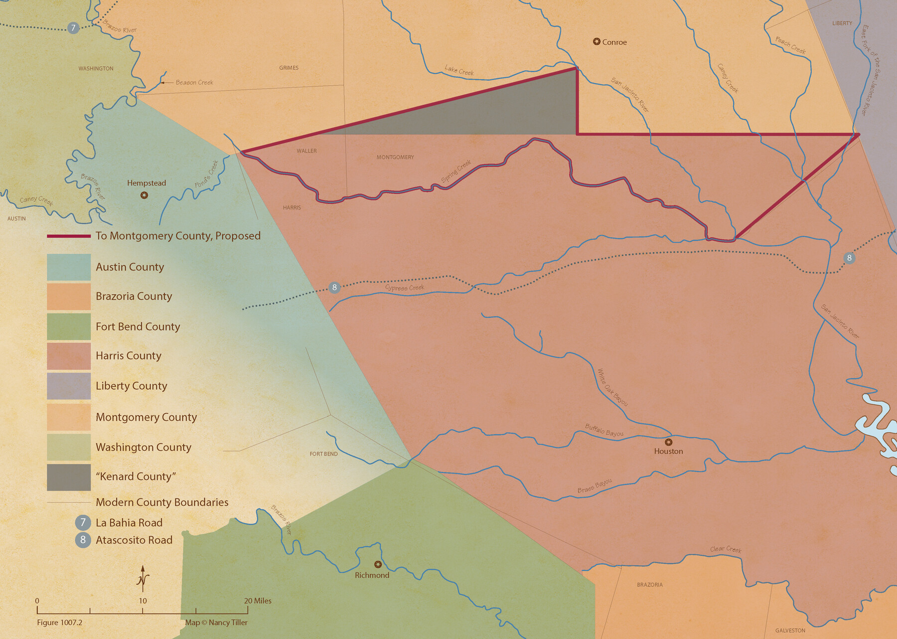
Letter from Jesse Grimes Suggesting a Redefinition of the Boundary Between Harris and Montgomery Counties, April 30, 1838
Figure No. 1007.2 from 'A Boundary Atlas of Texas, 1821-1845' by Jim Tiller
-
Map/Doc
96381
-
Collection
Nancy and Jim Tiller Digital Collection
-
Object Dates
2020/1/1 (Creation Date)
-
People and Organizations
Jim Tiller (Author)
Nancy Tiller (Cartographer)
Gang Gong (GIS Professional)
-
Subjects
Atlas Republic of Texas Texas Boundaries
-
Height x Width
15.4 x 21.7 inches
39.1 x 55.1 cm
-
Medium
digital image
-
Comments
To purchase a digital PDF copy of "A Boundary Atlas of Texas, 1821-1845" see 96437.
Part of: Nancy and Jim Tiller Digital Collection
The Republic County of Lamar. Spring 1842

Print $20.00
The Republic County of Lamar. Spring 1842
2020
Size 16.4 x 21.7 inches
Map/Doc 96204
The Republic County of Robertson. November 28, 1839

Print $20.00
The Republic County of Robertson. November 28, 1839
2020
Size 18.9 x 21.6 inches
Map/Doc 96260
The Republic County of Robertson. January 30, 1841

Print $20.00
The Republic County of Robertson. January 30, 1841
2020
Size 16.9 x 21.7 inches
Map/Doc 96261
The Republic County of Bowie. January 28, 1841

Print $20.00
The Republic County of Bowie. January 28, 1841
2020
Size 19.5 x 21.7 inches
Map/Doc 96103
The Republic County of Matagorda. Proposed, Late Fall 1837-January 1, 1838

Print $20.00
The Republic County of Matagorda. Proposed, Late Fall 1837-January 1, 1838
2020
Size 21.0 x 21.7 inches
Map/Doc 96215
The Republic County of Nacogdoches. December 29, 1845

Print $20.00
The Republic County of Nacogdoches. December 29, 1845
2020
Size 15.9 x 21.8 inches
Map/Doc 96250
The Chief Justice County of Bexar. Lands in Conflict with Milam County

Print $20.00
The Chief Justice County of Bexar. Lands in Conflict with Milam County
2020
Size 14.6 x 21.6 inches
Map/Doc 96039
DeWitt Empresario Colony. April 15, 1825

Print $20.00
DeWitt Empresario Colony. April 15, 1825
2020
Size 18.1 x 21.7 inches
Map/Doc 95991
The Mexican Department of Bexar. March 18, 1834

Print $20.00
The Mexican Department of Bexar. March 18, 1834
2020
Size 16.0 x 21.7 inches
Map/Doc 95970
de Leon Empresario Colony. April 30, 1829

Print $20.00
de Leon Empresario Colony. April 30, 1829
2020
Size 18.5 x 21.7 inches
Map/Doc 95990
The Republic County of Robertson. January 29, 1842

Print $20.00
The Republic County of Robertson. January 29, 1842
2020
Size 16.9 x 21.7 inches
Map/Doc 96262
The Judicial District/County of Waco. Abolished, Spring 1842

Print $20.00
The Judicial District/County of Waco. Abolished, Spring 1842
2020
Size 16.2 x 21.7 inches
Map/Doc 96353
You may also like
Flight Mission No. DQN-1K, Frame 153, Calhoun County

Print $20.00
- Digital $50.00
Flight Mission No. DQN-1K, Frame 153, Calhoun County
1953
Size 18.6 x 22.3 inches
Map/Doc 84212
Working Sketch in Gray and Donley Counties

Print $20.00
- Digital $50.00
Working Sketch in Gray and Donley Counties
1910
Size 28.4 x 26.7 inches
Map/Doc 90707
Webb County Rolled Sketch 76

Print $20.00
- Digital $50.00
Webb County Rolled Sketch 76
1959
Size 32.8 x 44.0 inches
Map/Doc 10133
Dimmit County Working Sketch 53

Print $20.00
- Digital $50.00
Dimmit County Working Sketch 53
1990
Size 25.5 x 26.0 inches
Map/Doc 68714
Right of Way and Track Map - Houston & Texas Central R.R. operated by the T. and N. O. R.R. Co. - Main Line

Print $40.00
- Digital $50.00
Right of Way and Track Map - Houston & Texas Central R.R. operated by the T. and N. O. R.R. Co. - Main Line
1918
Size 25.2 x 57.8 inches
Map/Doc 82859
Zavala County Sketch File 37

Print $4.00
- Digital $50.00
Zavala County Sketch File 37
Size 12.9 x 8.1 inches
Map/Doc 41402
Brazoria County Rolled Sketch 28

Print $40.00
- Digital $50.00
Brazoria County Rolled Sketch 28
Size 35.7 x 56.8 inches
Map/Doc 8458
Map of Washington County, Texas

Print $20.00
- Digital $50.00
Map of Washington County, Texas
1879
Size 14.4 x 21.6 inches
Map/Doc 765
Matagorda County NRC Article 33.136 Sketch 18

Print $24.00
Matagorda County NRC Article 33.136 Sketch 18
2023
Map/Doc 97283
Chambers County Sketch File 17

Print $40.00
- Digital $50.00
Chambers County Sketch File 17
1878
Size 12.4 x 15.6 inches
Map/Doc 17567
Kaufman County Working Sketch 5

Print $20.00
- Digital $50.00
Kaufman County Working Sketch 5
1922
Size 31.8 x 46.0 inches
Map/Doc 66668
Copy of Surveyor's Field Book, Morris Browning - In Blocks 7, 5 & 4, I&GNRRCo., Hutchinson and Carson Counties, Texas

Print $2.00
- Digital $50.00
Copy of Surveyor's Field Book, Morris Browning - In Blocks 7, 5 & 4, I&GNRRCo., Hutchinson and Carson Counties, Texas
1888
Size 7.0 x 8.9 inches
Map/Doc 62261