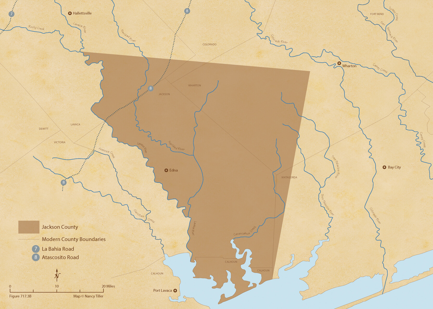
The Republic County of Jackson. 1840
Figure No. 717.3 from 'A Boundary Atlas of Texas, 1821-1845' by Jim Tiller
-
Map/Doc
96186
-
Collection
Nancy and Jim Tiller Digital Collection
-
Object Dates
2020/1/1 (Creation Date)
-
People and Organizations
Jim Tiller (Author)
Nancy Tiller (Cartographer)
Gang Gong (GIS Professional)
-
Counties
Jackson
-
Subjects
Atlas County Republic of Texas Texas Boundaries
-
Height x Width
15.6 x 21.8 inches
39.6 x 55.4 cm
-
Medium
digital image
-
Comments
To purchase a digital PDF copy of "A Boundary Atlas of Texas, 1821-1845" see 96437.
Part of: Nancy and Jim Tiller Digital Collection
The Chief Justice County of Jasper. Lands in Conflict with Sabine County

Print $20.00
The Chief Justice County of Jasper. Lands in Conflict with Sabine County
2020
Size 18.3 x 21.7 inches
Map/Doc 96053
The Republic County of Austin. January 28, 1841

Print $20.00
The Republic County of Austin. January 28, 1841
2020
Size 14.7 x 21.7 inches
Map/Doc 96085
The Mexican Municipality of Jefferson. Defined, December 9, 1835

Print $20.00
The Mexican Municipality of Jefferson. Defined, December 9, 1835
2020
Size 15.5 x 21.7 inches
Map/Doc 96024
The Land Offices. No. 4, Nacogdoches, December 22, 1836

Print $20.00
The Land Offices. No. 4, Nacogdoches, December 22, 1836
2020
Size 14.8 x 21.7 inches
Map/Doc 96417
The Land Offices. No. 11, Victoria, December 22, 1836

Print $20.00
The Land Offices. No. 11, Victoria, December 22, 1836
2020
Size 21.8 x 21.7 inches
Map/Doc 96424
The Republic County of Washington. February 1, 1844

Print $20.00
The Republic County of Washington. February 1, 1844
2020
Size 11.8 x 21.7 inches
Map/Doc 96309
DeWitt Empresario Colony. April 15, 1825

Print $20.00
DeWitt Empresario Colony. April 15, 1825
2020
Size 18.1 x 21.7 inches
Map/Doc 95991
Text and Map Related to the Creation of a New County Out of Red River and Shelby Counties (Unnamed), Undated

Print $20.00
Text and Map Related to the Creation of a New County Out of Red River and Shelby Counties (Unnamed), Undated
2020
Size 12.5 x 19.7 inches
Map/Doc 96403
The Mexican Municipality of San Patricio. April 1834

Print $20.00
The Mexican Municipality of San Patricio. April 1834
2020
Size 16.0 x 21.7 inches
Map/Doc 96034
From Citizens of Shelby and Red River Counties Living East of the Sabine River and Southwest of the Sulphur Fork of Red River for the Creation of a New County to be Called Green, March 11, 1837/April 1, 1837

Print $20.00
From Citizens of Shelby and Red River Counties Living East of the Sabine River and Southwest of the Sulphur Fork of Red River for the Creation of a New County to be Called Green, March 11, 1837/April 1, 1837
2020
Size 24.3 x 21.7 inches
Map/Doc 96373
The Republic County of Fayette. May 3, 1838

Print $20.00
The Republic County of Fayette. May 3, 1838
2020
Size 14.7 x 21.7 inches
Map/Doc 96132
The Land Offices. No. 2, San Augustine, December 22, 1836

Print $20.00
The Land Offices. No. 2, San Augustine, December 22, 1836
2020
Size 19.7 x 18.4 inches
Map/Doc 96415
You may also like
Schleicher County Sketch File 45

Print $22.00
- Digital $50.00
Schleicher County Sketch File 45
1972
Size 4.2 x 8.8 inches
Map/Doc 36552
Map of Location and Right of Way from El Paso, Tex. To New Mexico Line, Rio Grande & El Paso R.R.

Print $20.00
- Digital $50.00
Map of Location and Right of Way from El Paso, Tex. To New Mexico Line, Rio Grande & El Paso R.R.
Size 14.0 x 20.9 inches
Map/Doc 64085

Edwards County Working Sketch 94

Print $40.00
- Digital $50.00
Edwards County Working Sketch 94
1968
Size 28.0 x 49.4 inches
Map/Doc 68970
Montgomery County Working Sketch 9

Print $20.00
- Digital $50.00
Montgomery County Working Sketch 9
1933
Size 26.4 x 39.6 inches
Map/Doc 71116
Cooke County Sketch File 37

Print $4.00
- Digital $50.00
Cooke County Sketch File 37
Size 13.1 x 8.0 inches
Map/Doc 19306
Hemphill County Sketch File 3

Print $8.00
- Digital $50.00
Hemphill County Sketch File 3
Size 11.4 x 6.5 inches
Map/Doc 26285
Trinity County Sketch File 10

Print $8.00
- Digital $50.00
Trinity County Sketch File 10
1858
Size 13.1 x 8.0 inches
Map/Doc 38527
Map and Street Guide of Austin, Texas and Urban Areas

Map and Street Guide of Austin, Texas and Urban Areas
1972
Size 48.6 x 33.9 inches
Map/Doc 82029
Gregg County Rolled Sketch 17

Print $20.00
- Digital $50.00
Gregg County Rolled Sketch 17
1933
Size 14.0 x 27.9 inches
Map/Doc 6040
Culberson County Rolled Sketch 29

Print $20.00
- Digital $50.00
Culberson County Rolled Sketch 29
Size 44.3 x 21.4 inches
Map/Doc 8745
Val Verde County Working Sketch 22

Print $20.00
- Digital $50.00
Val Verde County Working Sketch 22
1931
Size 27.6 x 33.0 inches
Map/Doc 72157