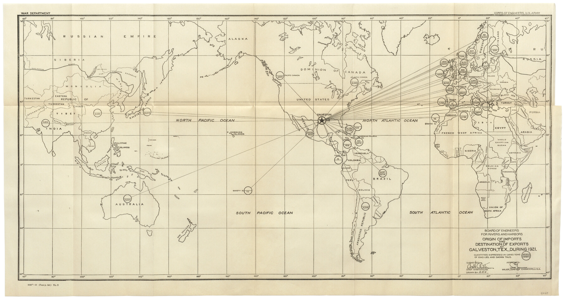
Origin of Imports and Destination of Exports at Galveston, Tex., during 1921
-
Map/Doc
97169
-
Collection
General Map Collection
-
Object Dates
1921 (Creation Date)
-
People and Organizations
War Department (Publisher)
Corps of Engineers, U.S. Army (Publisher)
-
Subjects
World
-
Height x Width
13.1 x 24.6 inches
33.3 x 62.5 cm
-
Comments
Item from "Port Series No. 6 - The Ports of Galveston, Houston, and Texas City, Texas" (97159)
Related maps
Port Series No. 6 - The Ports of Galveston, Houston, and Texas City, Texas

Port Series No. 6 - The Ports of Galveston, Houston, and Texas City, Texas
1924
Map/Doc 97159
Mosaic composed of aerial photographs - Galveston, Tex.

Print $20.00
- Digital $50.00
Mosaic composed of aerial photographs - Galveston, Tex.
1923
Size 15.3 x 33.3 inches
Map/Doc 97160
Port Facilities at Texas City, Tex.

Print $20.00
- Digital $50.00
Port Facilities at Texas City, Tex.
Size 13.9 x 15.9 inches
Map/Doc 97161
Origin of Exports, Destination of Imports at Texas City, Tex. during 1921

Print $20.00
- Digital $50.00
Origin of Exports, Destination of Imports at Texas City, Tex. during 1921
1921
Size 13.8 x 9.6 inches
Map/Doc 97162
Origin of Imports and Destination of Exports at Texas City, Tex., during 1921

Print $20.00
- Digital $50.00
Origin of Imports and Destination of Exports at Texas City, Tex., during 1921
1921
Size 13.4 x 24.9 inches
Map/Doc 97163
Vicinity map showing railroads serving the ports of Galveston, Houston and Texas City, Texas

Print $20.00
- Digital $50.00
Vicinity map showing railroads serving the ports of Galveston, Houston and Texas City, Texas
Size 9.3 x 14.8 inches
Map/Doc 97164
Territory served by the Galveston Bay Ports, Tex.

Print $20.00
- Digital $50.00
Territory served by the Galveston Bay Ports, Tex.
Size 17.1 x 16.0 inches
Map/Doc 97165
Mosaic composed of aerial photographs - Texas City, Tex.

Print $20.00
- Digital $50.00
Mosaic composed of aerial photographs - Texas City, Tex.
1923
Size 15.0 x 16.8 inches
Map/Doc 97166
Port Facilities at Houston, Tex.

Print $20.00
- Digital $50.00
Port Facilities at Houston, Tex.
Size 14.1 x 30.3 inches
Map/Doc 97167
Origin of Exports and Destination of Imports at Galveston during 1921

Print $20.00
- Digital $50.00
Origin of Exports and Destination of Imports at Galveston during 1921
1921
Size 13.7 x 19.9 inches
Map/Doc 97168
Origins of Exports and Destination of Imports at Houston during 1921

Print $20.00
- Digital $50.00
Origins of Exports and Destination of Imports at Houston during 1921
1921
Size 13.6 x 19.6 inches
Map/Doc 97170
Origins of Imports and Destination of Exports at Houston, Tex., during 1921

Print $20.00
- Digital $50.00
Origins of Imports and Destination of Exports at Houston, Tex., during 1921
1921
Size 14.2 x 23.1 inches
Map/Doc 97171
Mosaic composed of aerial photographs - Houston Ship Channel, Tex.

Print $20.00
- Digital $50.00
Mosaic composed of aerial photographs - Houston Ship Channel, Tex.
1923
Size 13.7 x 38.0 inches
Map/Doc 97172
Port Facilities at Galveston, Tex.

Print $20.00
- Digital $50.00
Port Facilities at Galveston, Tex.
Size 14.1 x 37.5 inches
Map/Doc 97173
Part of: General Map Collection
Schleicher County Working Sketch 24

Print $20.00
- Digital $50.00
Schleicher County Working Sketch 24
1955
Size 42.6 x 43.3 inches
Map/Doc 63826
Sherman County Sketch File 5

Print $2.00
- Digital $50.00
Sherman County Sketch File 5
1993
Size 14.6 x 9.0 inches
Map/Doc 36723
Flight Mission No. CUG-1P, Frame 51, Kleberg County

Print $20.00
- Digital $50.00
Flight Mission No. CUG-1P, Frame 51, Kleberg County
1956
Size 18.7 x 22.3 inches
Map/Doc 86129
Right of Way & Track Map, San Antonio & Aransas Pass Railway Co.

Print $40.00
- Digital $50.00
Right of Way & Track Map, San Antonio & Aransas Pass Railway Co.
1919
Size 25.3 x 56.7 inches
Map/Doc 64216
Travis County State Real Property Sketch 10

Print $20.00
- Digital $50.00
Travis County State Real Property Sketch 10
2002
Size 35.5 x 25.2 inches
Map/Doc 83550
[Surveys in Austin's Colony along Chocolate Bayou and Austin Bayou]
![192, [Surveys in Austin's Colony along Chocolate Bayou and Austin Bayou], General Map Collection](https://historictexasmaps.com/wmedia_w700/maps/192.tif.jpg)
Print $20.00
- Digital $50.00
[Surveys in Austin's Colony along Chocolate Bayou and Austin Bayou]
1830
Size 32.9 x 10.8 inches
Map/Doc 192
Baylor County Sketch File 17

Print $4.00
- Digital $50.00
Baylor County Sketch File 17
1872
Size 12.8 x 8.5 inches
Map/Doc 14189
Fort Bend County Sketch File 20

Print $2.00
- Digital $50.00
Fort Bend County Sketch File 20
Size 8.9 x 9.4 inches
Map/Doc 22953
Crockett County Sketch File 25

Print $26.00
- Digital $50.00
Crockett County Sketch File 25
1881
Size 12.9 x 8.3 inches
Map/Doc 19703


Bowie County Sketch File A

Print $40.00
- Digital $50.00
Bowie County Sketch File A
1902
Size 15.6 x 27.3 inches
Map/Doc 10946
You may also like
Jasper County

Print $40.00
- Digital $50.00
Jasper County
1946
Size 48.6 x 42.9 inches
Map/Doc 73192
McCulloch County Working Sketch 15

Print $20.00
- Digital $50.00
McCulloch County Working Sketch 15
1994
Size 33.2 x 34.0 inches
Map/Doc 70690
The Judicial District/County of Guadalupe. Created, January 29, 1842

Print $20.00
The Judicial District/County of Guadalupe. Created, January 29, 1842
2020
Size 16.7 x 21.7 inches
Map/Doc 96327
Washington County Sketch File 4

Print $4.00
- Digital $50.00
Washington County Sketch File 4
1863
Size 12.8 x 7.8 inches
Map/Doc 39650
Brazos River, Brazos River Sheet 1

Print $20.00
- Digital $50.00
Brazos River, Brazos River Sheet 1
1926
Size 20.6 x 24.6 inches
Map/Doc 78264
Burleson County

Print $20.00
- Digital $50.00
Burleson County
1884
Size 21.9 x 25.2 inches
Map/Doc 3349
Limestone County Working Sketch 18

Print $20.00
- Digital $50.00
Limestone County Working Sketch 18
1962
Size 45.5 x 38.7 inches
Map/Doc 70568
[Blocks C4, SI, and JK]
![90774, [Blocks C4, SI, and JK], Twichell Survey Records](https://historictexasmaps.com/wmedia_w700/maps/90774-1.tif.jpg)
Print $20.00
- Digital $50.00
[Blocks C4, SI, and JK]
Size 16.1 x 16.3 inches
Map/Doc 90774
General Highway Map, Jackson County, Texas

Print $20.00
General Highway Map, Jackson County, Texas
1940
Size 18.3 x 24.8 inches
Map/Doc 79140
Sutton County Working Sketch 14

Print $40.00
- Digital $50.00
Sutton County Working Sketch 14
1972
Size 59.5 x 36.8 inches
Map/Doc 62357

[Map of Area near Alamo showing proposed fortifications]
![88603, [Map of Area near Alamo showing proposed fortifications], National Archives Digital Map Collection](https://historictexasmaps.com/wmedia_w700/maps/88603.tif.jpg)
Print $20.00
[Map of Area near Alamo showing proposed fortifications]
1863
Size 31.9 x 27.7 inches
Map/Doc 88603