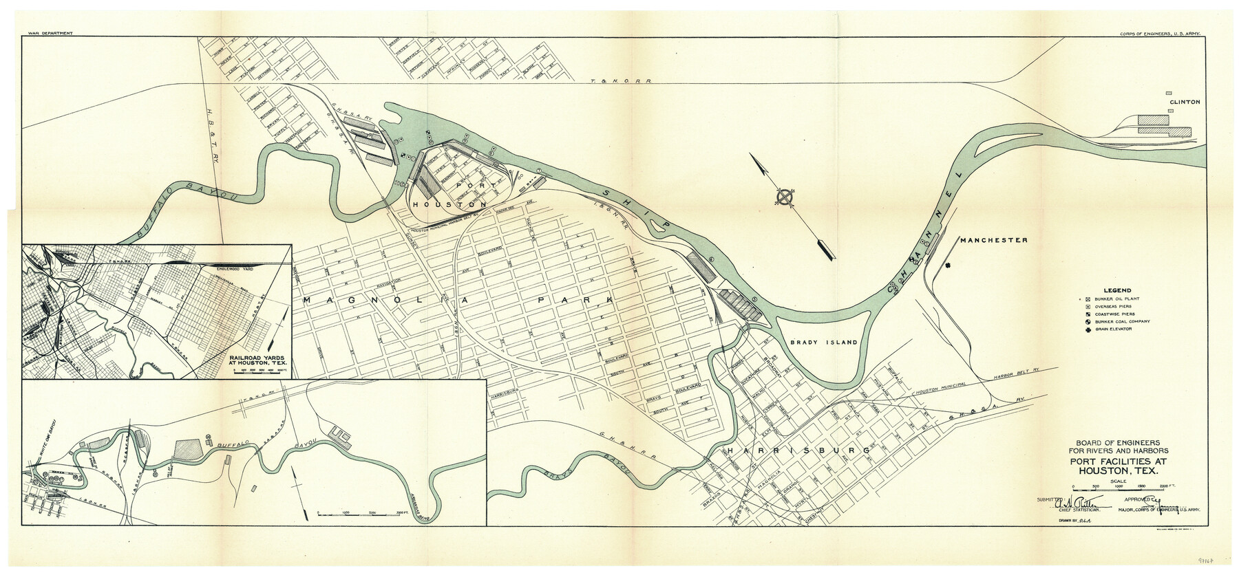
Port Facilities at Houston, Tex.
-
Map/Doc
97167
-
Collection
General Map Collection
-
People and Organizations
War Department (Publisher)
Corps of Engineers, U.S. Army (Publisher)
-
Counties
Harris
-
Subjects
City Coastal
-
Height x Width
14.1 x 30.3 inches
35.8 x 77.0 cm
-
Comments
Item from "Port Series No. 6 - The Ports of Galveston, Houston, and Texas City, Texas" (97159)
Related maps
Port Series No. 6 - The Ports of Galveston, Houston, and Texas City, Texas

Port Series No. 6 - The Ports of Galveston, Houston, and Texas City, Texas
1924
Map/Doc 97159
Mosaic composed of aerial photographs - Galveston, Tex.

Print $20.00
- Digital $50.00
Mosaic composed of aerial photographs - Galveston, Tex.
1923
Size 15.3 x 33.3 inches
Map/Doc 97160
Port Facilities at Texas City, Tex.

Print $20.00
- Digital $50.00
Port Facilities at Texas City, Tex.
Size 13.9 x 15.9 inches
Map/Doc 97161
Origin of Exports, Destination of Imports at Texas City, Tex. during 1921

Print $20.00
- Digital $50.00
Origin of Exports, Destination of Imports at Texas City, Tex. during 1921
1921
Size 13.8 x 9.6 inches
Map/Doc 97162
Origin of Imports and Destination of Exports at Texas City, Tex., during 1921

Print $20.00
- Digital $50.00
Origin of Imports and Destination of Exports at Texas City, Tex., during 1921
1921
Size 13.4 x 24.9 inches
Map/Doc 97163
Vicinity map showing railroads serving the ports of Galveston, Houston and Texas City, Texas

Print $20.00
- Digital $50.00
Vicinity map showing railroads serving the ports of Galveston, Houston and Texas City, Texas
Size 9.3 x 14.8 inches
Map/Doc 97164
Territory served by the Galveston Bay Ports, Tex.

Print $20.00
- Digital $50.00
Territory served by the Galveston Bay Ports, Tex.
Size 17.1 x 16.0 inches
Map/Doc 97165
Mosaic composed of aerial photographs - Texas City, Tex.

Print $20.00
- Digital $50.00
Mosaic composed of aerial photographs - Texas City, Tex.
1923
Size 15.0 x 16.8 inches
Map/Doc 97166
Origin of Exports and Destination of Imports at Galveston during 1921

Print $20.00
- Digital $50.00
Origin of Exports and Destination of Imports at Galveston during 1921
1921
Size 13.7 x 19.9 inches
Map/Doc 97168
Origin of Imports and Destination of Exports at Galveston, Tex., during 1921

Print $20.00
- Digital $50.00
Origin of Imports and Destination of Exports at Galveston, Tex., during 1921
1921
Size 13.1 x 24.6 inches
Map/Doc 97169
Origins of Exports and Destination of Imports at Houston during 1921

Print $20.00
- Digital $50.00
Origins of Exports and Destination of Imports at Houston during 1921
1921
Size 13.6 x 19.6 inches
Map/Doc 97170
Origins of Imports and Destination of Exports at Houston, Tex., during 1921

Print $20.00
- Digital $50.00
Origins of Imports and Destination of Exports at Houston, Tex., during 1921
1921
Size 14.2 x 23.1 inches
Map/Doc 97171
Mosaic composed of aerial photographs - Houston Ship Channel, Tex.

Print $20.00
- Digital $50.00
Mosaic composed of aerial photographs - Houston Ship Channel, Tex.
1923
Size 13.7 x 38.0 inches
Map/Doc 97172
Port Facilities at Galveston, Tex.

Print $20.00
- Digital $50.00
Port Facilities at Galveston, Tex.
Size 14.1 x 37.5 inches
Map/Doc 97173
Part of: General Map Collection
Flight Mission No. BRA-16M, Frame 63, Jefferson County

Print $20.00
- Digital $50.00
Flight Mission No. BRA-16M, Frame 63, Jefferson County
1953
Size 18.6 x 22.3 inches
Map/Doc 85680
Ellis County Sketch File 1

Print $6.00
- Digital $50.00
Ellis County Sketch File 1
1849
Size 6.5 x 7.9 inches
Map/Doc 21824
Flight Mission No. CGI-3N, Frame 69, Cameron County

Print $20.00
- Digital $50.00
Flight Mission No. CGI-3N, Frame 69, Cameron County
1954
Size 18.4 x 22.1 inches
Map/Doc 84563
Bee County Sketch File 32

Print $4.00
- Digital $50.00
Bee County Sketch File 32
Size 7.9 x 12.6 inches
Map/Doc 14347
Bowie County Sketch File 8f

Print $10.00
- Digital $50.00
Bowie County Sketch File 8f
1928
Size 8.1 x 5.2 inches
Map/Doc 14902
Le Nouveau Mexique avec la partie Septentrionale de l'Ancien ou de la Nouvelle Espagne

Print $20.00
- Digital $50.00
Le Nouveau Mexique avec la partie Septentrionale de l'Ancien ou de la Nouvelle Espagne
1780
Size 10.0 x 14.4 inches
Map/Doc 97277
Bastrop County Boundary File 1

Print $4.00
- Digital $50.00
Bastrop County Boundary File 1
Size 12.6 x 8.3 inches
Map/Doc 50313
Galveston Bay and Approaches

Print $40.00
- Digital $50.00
Galveston Bay and Approaches
1982
Size 51.4 x 37.0 inches
Map/Doc 69885
Cass County Working Sketch 30

Print $20.00
- Digital $50.00
Cass County Working Sketch 30
1980
Size 41.4 x 35.0 inches
Map/Doc 67933
Schleicher County

Print $40.00
- Digital $50.00
Schleicher County
1940
Size 39.4 x 56.0 inches
Map/Doc 63028
Flight Mission No. BRE-2P, Frame 66, Nueces County

Print $20.00
- Digital $50.00
Flight Mission No. BRE-2P, Frame 66, Nueces County
1956
Size 18.6 x 22.5 inches
Map/Doc 86761
Live Oak County Rolled Sketch 8

Print $20.00
- Digital $50.00
Live Oak County Rolled Sketch 8
1969
Size 43.5 x 32.8 inches
Map/Doc 9455
You may also like
Harbor of Brazos Santiago, Texas

Print $20.00
- Digital $50.00
Harbor of Brazos Santiago, Texas
1887
Size 27.1 x 18.3 inches
Map/Doc 72995
San Jacinto County Working Sketch 38

Print $40.00
- Digital $50.00
San Jacinto County Working Sketch 38
1966
Size 41.5 x 55.9 inches
Map/Doc 63751
Matagorda County Sketch File 14

Print $40.00
- Digital $50.00
Matagorda County Sketch File 14
Size 13.5 x 14.8 inches
Map/Doc 30772
Morris County Rolled Sketch 2A

Print $20.00
- Digital $50.00
Morris County Rolled Sketch 2A
Size 24.0 x 18.7 inches
Map/Doc 10286
Galveston County Sketch File 65

Print $70.00
- Digital $50.00
Galveston County Sketch File 65
1892
Size 8.7 x 5.8 inches
Map/Doc 23717
Cochran County Sketch File 7

Print $10.00
- Digital $50.00
Cochran County Sketch File 7
1940
Size 11.2 x 8.6 inches
Map/Doc 18550
Galveston Bay and Approaches

Print $20.00
- Digital $50.00
Galveston Bay and Approaches
1938
Size 45.4 x 34.6 inches
Map/Doc 69875
Reeves County Working Sketch 53

Print $40.00
- Digital $50.00
Reeves County Working Sketch 53
1977
Size 70.3 x 42.6 inches
Map/Doc 63496
Flight Mission No. CRC-2R, Frame 194, Chambers County

Print $20.00
- Digital $50.00
Flight Mission No. CRC-2R, Frame 194, Chambers County
1956
Size 18.8 x 22.6 inches
Map/Doc 84772
Edwards County Sketch File 27

Print $6.00
- Digital $50.00
Edwards County Sketch File 27
1913
Size 10.5 x 16.5 inches
Map/Doc 21755
Flight Mission No. DIX-5P, Frame 104, Aransas County

Print $20.00
- Digital $50.00
Flight Mission No. DIX-5P, Frame 104, Aransas County
1956
Size 17.8 x 18.5 inches
Map/Doc 83782
Hardin County Sketch File 50

Print $5.00
- Digital $50.00
Hardin County Sketch File 50
Size 13.5 x 9.2 inches
Map/Doc 25204