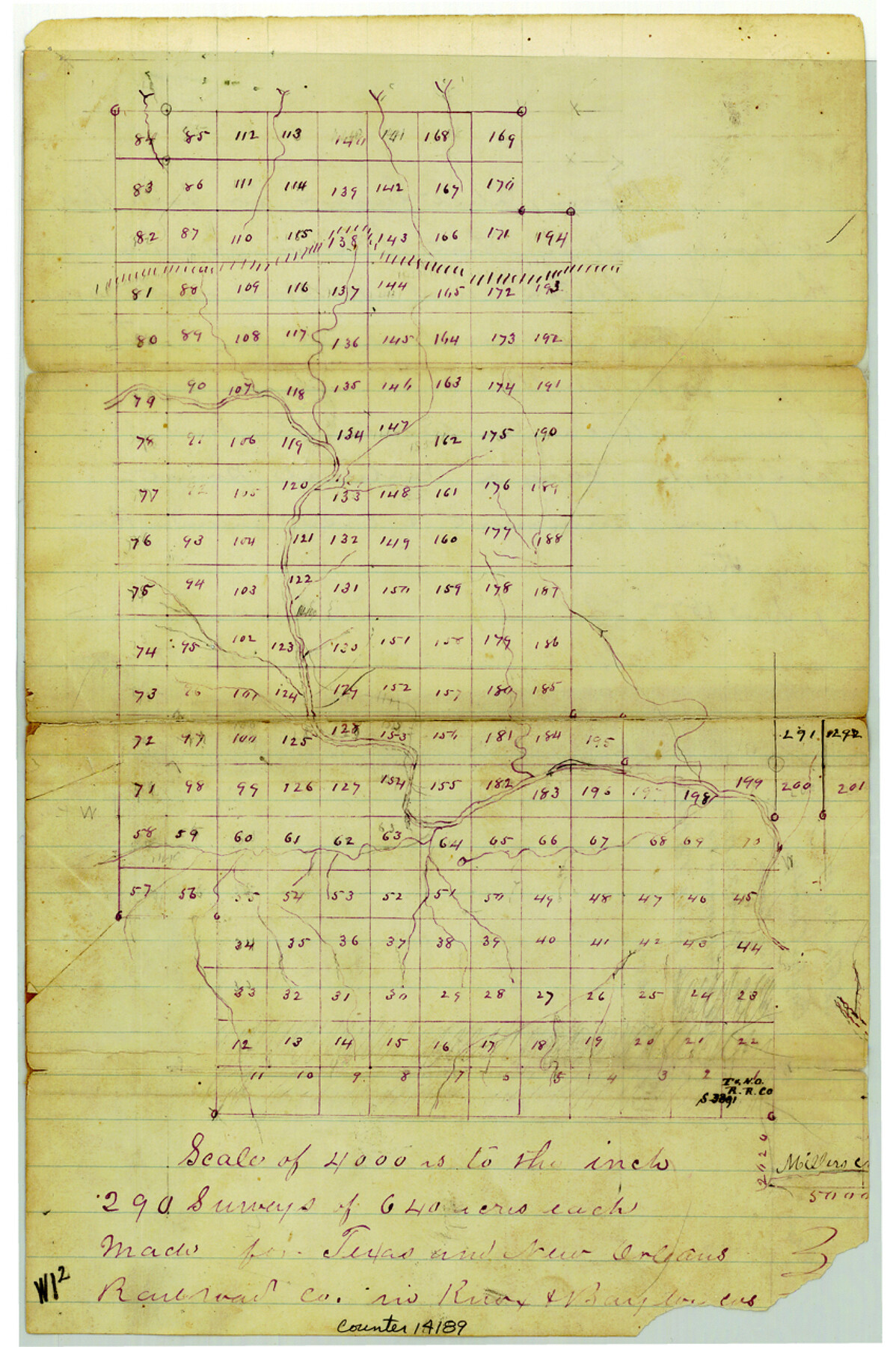
Baylor County Sketch File 17
[Sketch of T. & N. O. R.R. Co. surveys]
-
Map/Doc
14189
-
Collection
General Map Collection
-
Object Dates
1872/6/7 (Creation Date)
-
People and Organizations
E. Boon (Surveyor/Engineer)
-
Counties
Baylor
-
Subjects
Surveying Sketch File
-
Height x Width
12.8 x 8.5 inches
32.5 x 21.6 cm
-
Medium
paper, manuscript
-
Scale
1" = 4000 varas
-
Features
Miller's Creek
Part of: General Map Collection
Andrews County Rolled Sketch 33

Print $40.00
- Digital $50.00
Andrews County Rolled Sketch 33
Size 131.2 x 22.0 inches
Map/Doc 9003
Nacogdoches County Working Sketch Graphic Index

Print $20.00
- Digital $50.00
Nacogdoches County Working Sketch Graphic Index
1950
Size 46.9 x 41.3 inches
Map/Doc 76651
Flight Mission No. DAG-16K, Frame 74, Matagorda County

Print $20.00
- Digital $50.00
Flight Mission No. DAG-16K, Frame 74, Matagorda County
1952
Size 18.6 x 22.3 inches
Map/Doc 86320
Midland County Working Sketch 13

Print $40.00
- Digital $50.00
Midland County Working Sketch 13
1951
Size 24.3 x 48.5 inches
Map/Doc 70993
Liberty County Working Sketch 12

Print $20.00
- Digital $50.00
Liberty County Working Sketch 12
1914
Size 14.0 x 17.5 inches
Map/Doc 70471
Houston & Great Northern RR through Smith & other counties

Print $66.00
- Digital $50.00
Houston & Great Northern RR through Smith & other counties
1872
Size 14.2 x 8.4 inches
Map/Doc 64339
El Paso County Working Sketch 27

Print $20.00
- Digital $50.00
El Paso County Working Sketch 27
1963
Size 34.2 x 13.2 inches
Map/Doc 69049
Map of Montague County

Print $20.00
- Digital $50.00
Map of Montague County
1868
Size 24.1 x 19.7 inches
Map/Doc 3887
United States - Gulf Coast - Padre I. and Laguna Madre Lat. 27° 12' to Lat. 26° 33' Texas

Print $20.00
- Digital $50.00
United States - Gulf Coast - Padre I. and Laguna Madre Lat. 27° 12' to Lat. 26° 33' Texas
1913
Size 27.0 x 18.2 inches
Map/Doc 72814
Jim Wells Co.

Print $20.00
- Digital $50.00
Jim Wells Co.
1966
Size 40.3 x 28.9 inches
Map/Doc 77331
Map of Mexico, including Yucatan & Upper California exhibiting the chief cities and towns, the principal travelling routes &c.

Print $20.00
- Digital $50.00
Map of Mexico, including Yucatan & Upper California exhibiting the chief cities and towns, the principal travelling routes &c.
1847
Size 21.9 x 29.6 inches
Map/Doc 94017
DeWitt County Sketch File 7

Print $2.00
- Digital $50.00
DeWitt County Sketch File 7
1876
Size 11.3 x 9.0 inches
Map/Doc 20817
You may also like
Flight Mission No. CGI-4N, Frame 180, Cameron County

Print $20.00
- Digital $50.00
Flight Mission No. CGI-4N, Frame 180, Cameron County
1955
Size 18.5 x 22.3 inches
Map/Doc 84683
Matagorda Bay and Approaches

Print $20.00
- Digital $50.00
Matagorda Bay and Approaches
1974
Size 35.1 x 44.6 inches
Map/Doc 73386
Map of Baffin & Alazan Bays, Cayo Infiernillo in Kenedy & Kleberg Counties Showing Subdivision for Mineral Development

Print $40.00
- Digital $50.00
Map of Baffin & Alazan Bays, Cayo Infiernillo in Kenedy & Kleberg Counties Showing Subdivision for Mineral Development
1949
Size 30.5 x 54.2 inches
Map/Doc 3017
Scurry County Rolled Sketch 10

Print $20.00
- Digital $50.00
Scurry County Rolled Sketch 10
1966
Size 22.7 x 18.3 inches
Map/Doc 7770
Midland County Rolled Sketch 1

Print $20.00
- Digital $50.00
Midland County Rolled Sketch 1
1940
Size 32.9 x 35.0 inches
Map/Doc 9512
The Mexican Municipality of Matagorda. Created, March 6, 1834

Print $20.00
The Mexican Municipality of Matagorda. Created, March 6, 1834
2020
Size 15.9 x 21.7 inches
Map/Doc 96025
Val Verde County Rolled Sketch 56

Print $20.00
- Digital $50.00
Val Verde County Rolled Sketch 56
1941
Size 39.3 x 22.8 inches
Map/Doc 8125
Navarro County Working Sketch 4

Print $20.00
- Digital $50.00
Navarro County Working Sketch 4
1922
Size 20.8 x 20.9 inches
Map/Doc 71234
Falls County Sketch File 25

Print $7.00
- Digital $50.00
Falls County Sketch File 25
1968
Size 10.4 x 8.2 inches
Map/Doc 22430
Denton County Sketch File 22

Print $4.00
- Digital $50.00
Denton County Sketch File 22
1872
Size 8.5 x 16.0 inches
Map/Doc 20746
McLennan County Sketch File 4

Print $4.00
- Digital $50.00
McLennan County Sketch File 4
1852
Size 12.7 x 8.2 inches
Map/Doc 31235
Parker County Sketch File 3a

Print $40.00
- Digital $50.00
Parker County Sketch File 3a
Size 12.7 x 12.8 inches
Map/Doc 33523