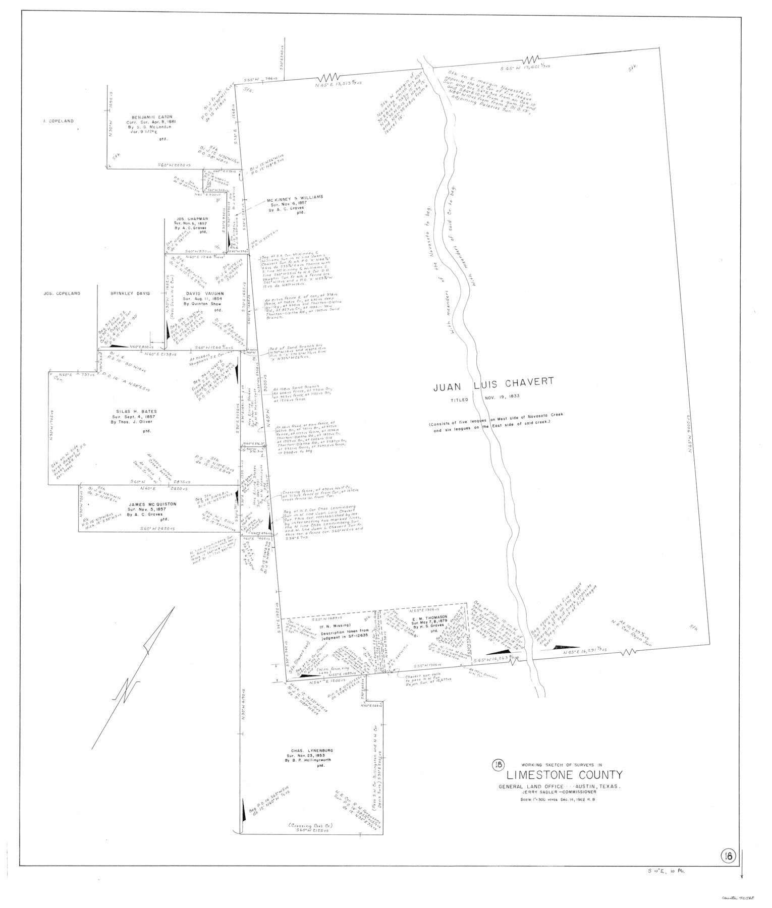
Limestone County Working Sketch 18
-
Map/Doc
70568
-
Collection
General Map Collection
-
Object Dates
12/14/1962 (Creation Date)
-
People and Organizations
Roy Buckholts (Draftsman)
-
Counties
Limestone
-
Subjects
Surveying Working Sketch
-
Height x Width
45.5 x 38.7 inches
115.6 x 98.3 cm
-
Scale
1" = 300 varas
Part of: General Map Collection
Hutchinson County Sketch File 33

Print $20.00
- Digital $50.00
Hutchinson County Sketch File 33
1926
Size 26.5 x 24.5 inches
Map/Doc 11821
Liberty County Rolled Sketch P

Print $33.00
- Digital $50.00
Liberty County Rolled Sketch P
Size 10.3 x 16.5 inches
Map/Doc 46545
Flight Mission No. DQN-1K, Frame 122, Calhoun County

Print $20.00
- Digital $50.00
Flight Mission No. DQN-1K, Frame 122, Calhoun County
1953
Size 18.5 x 22.2 inches
Map/Doc 84188
Anderson County Working Sketch 16

Print $20.00
- Digital $50.00
Anderson County Working Sketch 16
1938
Size 42.4 x 37.1 inches
Map/Doc 67016
Maps & Lists Showing Prison Lands (Oil & Gas) Leased as of June 1955

Digital $50.00
Maps & Lists Showing Prison Lands (Oil & Gas) Leased as of June 1955
Size 11.2 x 8.7 inches
Map/Doc 62871
Zavala County Sketch File 10a

Print $6.00
- Digital $50.00
Zavala County Sketch File 10a
1885
Size 14.6 x 8.8 inches
Map/Doc 41267
Leon County Rolled Sketch 5

Print $20.00
- Digital $50.00
Leon County Rolled Sketch 5
1947
Size 33.7 x 34.8 inches
Map/Doc 9427
Dawson County Rolled Sketch 7

Print $20.00
- Digital $50.00
Dawson County Rolled Sketch 7
Size 18.5 x 39.3 inches
Map/Doc 5692
Flight Mission No. CUG-3P, Frame 170, Kleberg County

Print $20.00
- Digital $50.00
Flight Mission No. CUG-3P, Frame 170, Kleberg County
1956
Size 18.6 x 22.2 inches
Map/Doc 86290
Zavala County Working Sketch 6

Print $20.00
- Digital $50.00
Zavala County Working Sketch 6
1942
Size 30.8 x 26.5 inches
Map/Doc 62081
Houston & Texas Central

Print $40.00
- Digital $50.00
Houston & Texas Central
Size 24.1 x 56.4 inches
Map/Doc 64797
Brazos River, Brazos River Sheet 5

Print $4.00
- Digital $50.00
Brazos River, Brazos River Sheet 5
1926
Size 29.4 x 22.5 inches
Map/Doc 65298
You may also like
Hudspeth County Working Sketch 25

Print $20.00
- Digital $50.00
Hudspeth County Working Sketch 25
1971
Size 24.6 x 28.0 inches
Map/Doc 66307
Jefferson Co.

Print $20.00
- Digital $50.00
Jefferson Co.
1918
Size 47.1 x 41.0 inches
Map/Doc 66884
El Paso County Working Sketch 39

Print $20.00
- Digital $50.00
El Paso County Working Sketch 39
1984
Size 45.7 x 37.1 inches
Map/Doc 69061
Atascosa County Sketch File 41

Print $8.00
- Digital $50.00
Atascosa County Sketch File 41
1956
Size 11.3 x 8.8 inches
Map/Doc 13837
Brewster County Rolled Sketch 78

Print $20.00
- Digital $50.00
Brewster County Rolled Sketch 78
1945
Size 19.8 x 28.0 inches
Map/Doc 5243
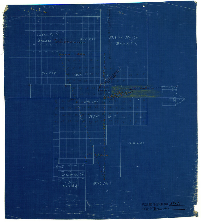
Brewster County Rolled Sketch 38A
Print $20.00
- Digital $50.00
Brewster County Rolled Sketch 38A
Size 15.6 x 14.1 inches
Map/Doc 5219
Lamar County Sketch File 1

Print $4.00
- Digital $50.00
Lamar County Sketch File 1
1849
Size 8.0 x 8.2 inches
Map/Doc 29271

Dallas County Boundary File 7 and 7a and 7b

Print $8.00
- Digital $50.00
Dallas County Boundary File 7 and 7a and 7b
Size 11.2 x 8.6 inches
Map/Doc 52291
Belton and Stillhouse Hollow Reservoirs (Verso)

Belton and Stillhouse Hollow Reservoirs (Verso)
1972
Size 29.3 x 22.7 inches
Map/Doc 94173
Anderson County Working Sketch 5

Print $20.00
- Digital $50.00
Anderson County Working Sketch 5
1913
Size 15.0 x 15.3 inches
Map/Doc 67004
Reagan County Working Sketch 39

Print $20.00
- Digital $50.00
Reagan County Working Sketch 39
1971
Size 22.5 x 36.1 inches
Map/Doc 71881