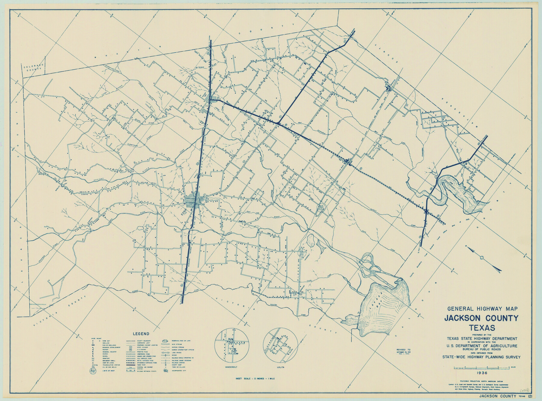
General Highway Map, Jackson County, Texas
-
Map/Doc
79140
-
Collection
Texas State Library and Archives
-
Object Dates
1940 (Creation Date)
-
People and Organizations
Texas State Highway Department (Publisher)
-
Counties
Jackson
-
Subjects
County
-
Height x Width
18.3 x 24.8 inches
46.5 x 63.0 cm
-
Comments
Prints available courtesy of the Texas State Library and Archives.
More info can be found here: TSLAC Map 04903
Part of: Texas State Library and Archives
Preliminary Chart of the Entrance to Matagorda Bay, Texas

Print $20.00
Preliminary Chart of the Entrance to Matagorda Bay, Texas
1857
Size 20.2 x 32.9 inches
Map/Doc 76247
General Highway Map, Hays County, Texas

Print $20.00
General Highway Map, Hays County, Texas
1961
Size 18.1 x 24.7 inches
Map/Doc 79513
Preliminary Chart of San Luis Pass, Texas

Print $20.00
Preliminary Chart of San Luis Pass, Texas
1853
Size 16.4 x 21.2 inches
Map/Doc 76251
General Highway Map, Parker County, Texas

Print $20.00
General Highway Map, Parker County, Texas
1961
Size 18.3 x 24.5 inches
Map/Doc 79625
General Highway Map. Detail of Cities and Towns in Dallas County, Texas [Dallas and vicinity]
![79067, General Highway Map. Detail of Cities and Towns in Dallas County, Texas [Dallas and vicinity], Texas State Library and Archives](https://historictexasmaps.com/wmedia_w700/maps/79067.tif.jpg)
Print $20.00
General Highway Map. Detail of Cities and Towns in Dallas County, Texas [Dallas and vicinity]
1936
Size 18.3 x 25.1 inches
Map/Doc 79067
General Highway Map, Scurry County, Texas

Print $20.00
General Highway Map, Scurry County, Texas
1961
Size 18.1 x 24.8 inches
Map/Doc 79650
General Highway Map, Jack County, Texas

Print $20.00
General Highway Map, Jack County, Texas
1940
Size 18.4 x 24.8 inches
Map/Doc 79139
Tracing From [Melish's] Map with Kansas and the Panhandle of Texas plotted thereon Showing the disputed Territory
![76190, Tracing From [Melish's] Map with Kansas and the Panhandle of Texas plotted thereon Showing the disputed Territory, Texas State Library and Archives](https://historictexasmaps.com/wmedia_w700/maps/76190.tif.jpg)
Print $20.00
Tracing From [Melish's] Map with Kansas and the Panhandle of Texas plotted thereon Showing the disputed Territory
1818
Size 18.8 x 19.8 inches
Map/Doc 76190
General Highway Map, Jackson County, Texas

Print $20.00
General Highway Map, Jackson County, Texas
1961
Size 18.2 x 24.7 inches
Map/Doc 79533
Railroad and County Map of Texas

Print $20.00
Railroad and County Map of Texas
1893
Size 24.2 x 27.2 inches
Map/Doc 76255
General Highway Map. Detail of Cities and Towns in Travis County, Texas. City Map, Austin and vicinity, Travis County, Texas

Print $20.00
General Highway Map. Detail of Cities and Towns in Travis County, Texas. City Map, Austin and vicinity, Travis County, Texas
1961
Size 18.2 x 24.9 inches
Map/Doc 79684
General Highway Map, Eastland County, Texas

Print $20.00
General Highway Map, Eastland County, Texas
1940
Size 18.1 x 24.8 inches
Map/Doc 79080
You may also like
[Part of North line of County, North of Block G]
![90807, [Part of North line of County, North of Block G], Twichell Survey Records](https://historictexasmaps.com/wmedia_w700/maps/90807-2.tif.jpg)
Print $3.00
- Digital $50.00
[Part of North line of County, North of Block G]
Size 12.1 x 11.7 inches
Map/Doc 90807
Presidio County Rolled Sketch 126

Print $20.00
- Digital $50.00
Presidio County Rolled Sketch 126
1986
Size 27.8 x 39.4 inches
Map/Doc 7397
[Map of] North America
![88884, [Map of] North America, General Map Collection](https://historictexasmaps.com/wmedia_w700/maps/88884.tif.jpg)
Print $3.00
- Digital $50.00
[Map of] North America
1834
Size 11.0 x 8.5 inches
Map/Doc 88884
Coke County Sketch File A

Print $4.00
- Digital $50.00
Coke County Sketch File A
1881
Size 12.5 x 7.0 inches
Map/Doc 18590
General Highway Map, Lampasas County, Texas

Print $20.00
General Highway Map, Lampasas County, Texas
1961
Size 18.2 x 24.7 inches
Map/Doc 79563
Floyd County Working Sketch 4

Print $20.00
- Digital $50.00
Floyd County Working Sketch 4
1952
Size 23.2 x 29.0 inches
Map/Doc 69183
Duval County Working Sketch 51

Print $20.00
- Digital $50.00
Duval County Working Sketch 51
1986
Size 27.3 x 35.3 inches
Map/Doc 68775
Flight Mission No. DCL-3C, Frame 107, Kenedy County

Print $20.00
- Digital $50.00
Flight Mission No. DCL-3C, Frame 107, Kenedy County
1943
Size 18.6 x 22.4 inches
Map/Doc 85802
Index to Field Notes, Plats: Spanish Archives

Index to Field Notes, Plats: Spanish Archives
1981
Map/Doc 94531

Genl. Austins Map of Texas With Parts of the Adjoining States

Print $20.00
- Digital $50.00
Genl. Austins Map of Texas With Parts of the Adjoining States
1840
Size 28.5 x 23.4 inches
Map/Doc 2116
Flight Mission No. CGI-3N, Frame 69, Cameron County

Print $20.00
- Digital $50.00
Flight Mission No. CGI-3N, Frame 69, Cameron County
1954
Size 18.4 x 22.1 inches
Map/Doc 84563