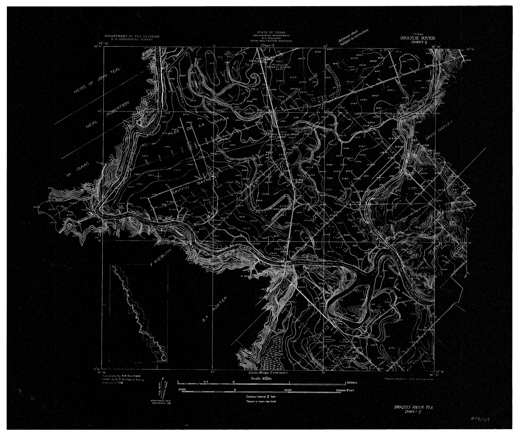
Brazos River, Brazos River Sheet 1
-
Map/Doc
78264
-
Collection
General Map Collection
-
Object Dates
1926 (Creation Date)
-
People and Organizations
Texas State Reclamation Department (Publisher)
R.W. Burchard (Surveyor/Engineer)
-
Counties
Brazos Burleson
-
Subjects
River Surveys Topographic
-
Height x Width
20.6 x 24.6 inches
52.3 x 62.5 cm
-
Comments
Brazos River Sheet 1 located north of the Jones Bridge Extension and south of the Brazos River Sheet 2.
Part of: General Map Collection
Map of San Antonio Bay and Vicinity in Aransas and Calhoun Counties showing subdivision for mineral development

Print $40.00
- Digital $50.00
Map of San Antonio Bay and Vicinity in Aransas and Calhoun Counties showing subdivision for mineral development
1939
Size 40.4 x 62.8 inches
Map/Doc 2925
Polk County Working Sketch 34

Print $20.00
- Digital $50.00
Polk County Working Sketch 34
1961
Size 41.3 x 42.0 inches
Map/Doc 71651
Nueces County Working Sketch 5

Print $20.00
- Digital $50.00
Nueces County Working Sketch 5
1949
Size 30.3 x 46.2 inches
Map/Doc 71307
Wilbarger County Working Sketch 12

Print $20.00
- Digital $50.00
Wilbarger County Working Sketch 12
1953
Size 42.2 x 33.5 inches
Map/Doc 72550
Map of San Patricio County

Print $40.00
- Digital $50.00
Map of San Patricio County
1896
Size 31.6 x 51.2 inches
Map/Doc 63018
Matagorda Bay and Approaches

Print $20.00
- Digital $50.00
Matagorda Bay and Approaches
1992
Size 36.6 x 44.6 inches
Map/Doc 73390
Matagorda County Sketch File 15

Print $48.00
- Digital $50.00
Matagorda County Sketch File 15
Size 8.7 x 11.2 inches
Map/Doc 30774
Hidalgo County Sketch File 16

Print $12.00
- Digital $50.00
Hidalgo County Sketch File 16
1914
Size 11.2 x 8.9 inches
Map/Doc 26437
Pecos County Rolled Sketch 104

Print $40.00
- Digital $50.00
Pecos County Rolled Sketch 104
Size 42.5 x 54.8 inches
Map/Doc 78197
Flight Mission No. DQN-6K, Frame 9, Calhoun County

Print $20.00
- Digital $50.00
Flight Mission No. DQN-6K, Frame 9, Calhoun County
1953
Size 18.5 x 22.1 inches
Map/Doc 84431
Map of Smith County

Print $20.00
- Digital $50.00
Map of Smith County
1905
Size 29.8 x 29.7 inches
Map/Doc 4041
Pecos County Sketch File 112

Print $16.00
- Digital $50.00
Pecos County Sketch File 112
1892
Size 11.2 x 8.6 inches
Map/Doc 34061
You may also like
Harris County NRC Article 33.136 Sketch 14

Print $50.00
- Digital $50.00
Harris County NRC Article 33.136 Sketch 14
Size 24.0 x 36.0 inches
Map/Doc 94816

Part of west line of Dawson County rough sketch from surveyor's blueprint

Print $20.00
- Digital $50.00
Part of west line of Dawson County rough sketch from surveyor's blueprint
1915
Size 14.0 x 20.2 inches
Map/Doc 90628
Webb County Working Sketch 68

Print $40.00
- Digital $50.00
Webb County Working Sketch 68
1967
Size 31.6 x 50.7 inches
Map/Doc 72435
Atascosa County Sketch File 32

Print $40.00
- Digital $50.00
Atascosa County Sketch File 32
Size 17.6 x 19.6 inches
Map/Doc 10864
Nautical Chart 892-SC - Intracoastal Waterway - Carlos Bay to Redfish Bay including Copano Bay, Texas

Print $20.00
- Digital $50.00
Nautical Chart 892-SC - Intracoastal Waterway - Carlos Bay to Redfish Bay including Copano Bay, Texas
1972
Size 16.0 x 18.7 inches
Map/Doc 75912
Burnet County Sketch File 36

Print $60.00
- Digital $50.00
Burnet County Sketch File 36
1935
Size 25.7 x 17.6 inches
Map/Doc 11025
Matagorda County Sketch File 34

Print $6.00
- Digital $50.00
Matagorda County Sketch File 34
1950
Size 14.3 x 8.8 inches
Map/Doc 30820
Freestone County Rolled Sketch 7

Print $20.00
- Digital $50.00
Freestone County Rolled Sketch 7
1918
Size 41.4 x 36.9 inches
Map/Doc 8895
Andrews County Boundary File 1

Print $133.00
- Digital $50.00
Andrews County Boundary File 1
Size 14.6 x 9.0 inches
Map/Doc 49664
Ashburn's San Antonio City Map

Ashburn's San Antonio City Map
1951
Size 24.5 x 19.5 inches
Map/Doc 97144
Stonewall County Working Sketch 29

Print $40.00
- Digital $50.00
Stonewall County Working Sketch 29
1979
Size 48.5 x 43.0 inches
Map/Doc 62336