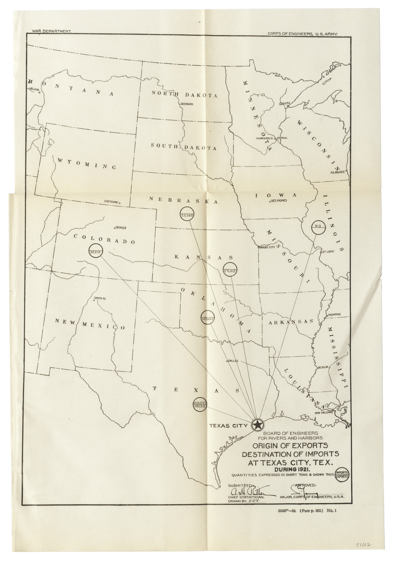
Origin of Exports, Destination of Imports at Texas City, Tex. during 1921
-
Map/Doc
97162
-
Collection
General Map Collection
-
Object Dates
1921 (Creation Date)
-
People and Organizations
War Department (Publisher)
Corps of Engineers, U.S. Army (Publisher)
-
Subjects
State of Texas
-
Height x Width
13.8 x 9.6 inches
35.1 x 24.4 cm
-
Comments
Item from "Port Series No. 6 - The Ports of Galveston, Houston, and Texas City, Texas" (97159)
Related maps
Port Series No. 6 - The Ports of Galveston, Houston, and Texas City, Texas

Port Series No. 6 - The Ports of Galveston, Houston, and Texas City, Texas
1924
Map/Doc 97159
Mosaic composed of aerial photographs - Galveston, Tex.

Print $20.00
- Digital $50.00
Mosaic composed of aerial photographs - Galveston, Tex.
1923
Size 15.3 x 33.3 inches
Map/Doc 97160
Port Facilities at Texas City, Tex.

Print $20.00
- Digital $50.00
Port Facilities at Texas City, Tex.
Size 13.9 x 15.9 inches
Map/Doc 97161
Origin of Imports and Destination of Exports at Texas City, Tex., during 1921

Print $20.00
- Digital $50.00
Origin of Imports and Destination of Exports at Texas City, Tex., during 1921
1921
Size 13.4 x 24.9 inches
Map/Doc 97163
Vicinity map showing railroads serving the ports of Galveston, Houston and Texas City, Texas

Print $20.00
- Digital $50.00
Vicinity map showing railroads serving the ports of Galveston, Houston and Texas City, Texas
Size 9.3 x 14.8 inches
Map/Doc 97164
Territory served by the Galveston Bay Ports, Tex.

Print $20.00
- Digital $50.00
Territory served by the Galveston Bay Ports, Tex.
Size 17.1 x 16.0 inches
Map/Doc 97165
Mosaic composed of aerial photographs - Texas City, Tex.

Print $20.00
- Digital $50.00
Mosaic composed of aerial photographs - Texas City, Tex.
1923
Size 15.0 x 16.8 inches
Map/Doc 97166
Port Facilities at Houston, Tex.

Print $20.00
- Digital $50.00
Port Facilities at Houston, Tex.
Size 14.1 x 30.3 inches
Map/Doc 97167
Origin of Exports and Destination of Imports at Galveston during 1921

Print $20.00
- Digital $50.00
Origin of Exports and Destination of Imports at Galveston during 1921
1921
Size 13.7 x 19.9 inches
Map/Doc 97168
Origin of Imports and Destination of Exports at Galveston, Tex., during 1921

Print $20.00
- Digital $50.00
Origin of Imports and Destination of Exports at Galveston, Tex., during 1921
1921
Size 13.1 x 24.6 inches
Map/Doc 97169
Origins of Exports and Destination of Imports at Houston during 1921

Print $20.00
- Digital $50.00
Origins of Exports and Destination of Imports at Houston during 1921
1921
Size 13.6 x 19.6 inches
Map/Doc 97170
Origins of Imports and Destination of Exports at Houston, Tex., during 1921

Print $20.00
- Digital $50.00
Origins of Imports and Destination of Exports at Houston, Tex., during 1921
1921
Size 14.2 x 23.1 inches
Map/Doc 97171
Mosaic composed of aerial photographs - Houston Ship Channel, Tex.

Print $20.00
- Digital $50.00
Mosaic composed of aerial photographs - Houston Ship Channel, Tex.
1923
Size 13.7 x 38.0 inches
Map/Doc 97172
Port Facilities at Galveston, Tex.

Print $20.00
- Digital $50.00
Port Facilities at Galveston, Tex.
Size 14.1 x 37.5 inches
Map/Doc 97173
Part of: General Map Collection
Rockwall County Sketch File 9

Print $20.00
Rockwall County Sketch File 9
Size 31.1 x 39.7 inches
Map/Doc 10590
Flight Mission No. CLL-1N, Frame 105, Willacy County

Print $20.00
- Digital $50.00
Flight Mission No. CLL-1N, Frame 105, Willacy County
1954
Size 18.4 x 22.1 inches
Map/Doc 87039
Township No. 3 South Range No. 19 West of the Indian Meridian

Print $20.00
- Digital $50.00
Township No. 3 South Range No. 19 West of the Indian Meridian
1875
Size 19.2 x 24.5 inches
Map/Doc 75182
Nueces County Rolled Sketch 51A

Print $20.00
- Digital $50.00
Nueces County Rolled Sketch 51A
1978
Size 27.6 x 39.1 inches
Map/Doc 6890
Culberson County Working Sketch 69

Print $40.00
- Digital $50.00
Culberson County Working Sketch 69
1975
Size 49.4 x 32.2 inches
Map/Doc 68523
Maps of Gulf Intracoastal Waterway, Texas - Sabine River to the Rio Grande and connecting waterways including ship channels

Print $20.00
- Digital $50.00
Maps of Gulf Intracoastal Waterway, Texas - Sabine River to the Rio Grande and connecting waterways including ship channels
1966
Size 14.5 x 22.2 inches
Map/Doc 61972
Culberson County Working Sketch 66

Print $40.00
- Digital $50.00
Culberson County Working Sketch 66
1975
Size 52.1 x 33.2 inches
Map/Doc 68520
Gulf of Mexico

Print $20.00
- Digital $50.00
Gulf of Mexico
1908
Size 18.2 x 27.2 inches
Map/Doc 72658
Flight Mission No. CUG-3P, Frame 23, Kleberg County

Print $20.00
- Digital $50.00
Flight Mission No. CUG-3P, Frame 23, Kleberg County
1956
Size 18.5 x 22.3 inches
Map/Doc 86233
The Making of America - Texas

The Making of America - Texas
1986
Size 20.7 x 27.3 inches
Map/Doc 96825
Jack County Sketch File 12

Print $9.00
- Digital $50.00
Jack County Sketch File 12
Size 5.6 x 8.3 inches
Map/Doc 27533
Presidio County Working Sketch 29a

Print $20.00
- Digital $50.00
Presidio County Working Sketch 29a
1946
Size 38.9 x 31.6 inches
Map/Doc 71706
You may also like
Webb County Sketch File 15-1

Print $20.00
- Digital $50.00
Webb County Sketch File 15-1
1935
Size 35.0 x 25.2 inches
Map/Doc 12634
Bosque County Sketch File 17

Print $8.00
- Digital $50.00
Bosque County Sketch File 17
1863
Size 13.0 x 7.9 inches
Map/Doc 14788
Victoria County Rolled Sketch 5

Print $20.00
- Digital $50.00
Victoria County Rolled Sketch 5
1961
Size 27.8 x 43.8 inches
Map/Doc 8151
Gaines County Rolled Sketch 19

Print $20.00
- Digital $50.00
Gaines County Rolled Sketch 19
1953
Size 22.2 x 17.2 inches
Map/Doc 5935
Johnson County Rolled Sketch 1

Print $20.00
- Digital $50.00
Johnson County Rolled Sketch 1
1941
Size 19.4 x 33.4 inches
Map/Doc 6446
Brewster County Working Sketch 10

Print $20.00
- Digital $50.00
Brewster County Working Sketch 10
1910
Size 17.8 x 16.8 inches
Map/Doc 67543
Austin Map and Street Guide [Recto]
![94162, Austin Map and Street Guide [Recto], General Map Collection](https://historictexasmaps.com/wmedia_w700/maps/94162.tif.jpg)
Austin Map and Street Guide [Recto]
1976
Size 35.4 x 22.7 inches
Map/Doc 94162
Map of a Route from Austin-City to Paso del Norte & c.

Print $20.00
- Digital $50.00
Map of a Route from Austin-City to Paso del Norte & c.
1849
Size 11.7 x 30.5 inches
Map/Doc 2121
Kleberg County Rolled Sketch 10-37

Print $20.00
- Digital $50.00
Kleberg County Rolled Sketch 10-37
1952
Size 37.6 x 36.6 inches
Map/Doc 9361
No. 1. Outline Map of the Rio Grande from its mouth up to Ringold Barracks

Print $20.00
- Digital $50.00
No. 1. Outline Map of the Rio Grande from its mouth up to Ringold Barracks
Size 24.8 x 18.3 inches
Map/Doc 72857
Harris County Working Sketch 25

Print $20.00
- Digital $50.00
Harris County Working Sketch 25
1928
Size 26.7 x 24.3 inches
Map/Doc 65917
