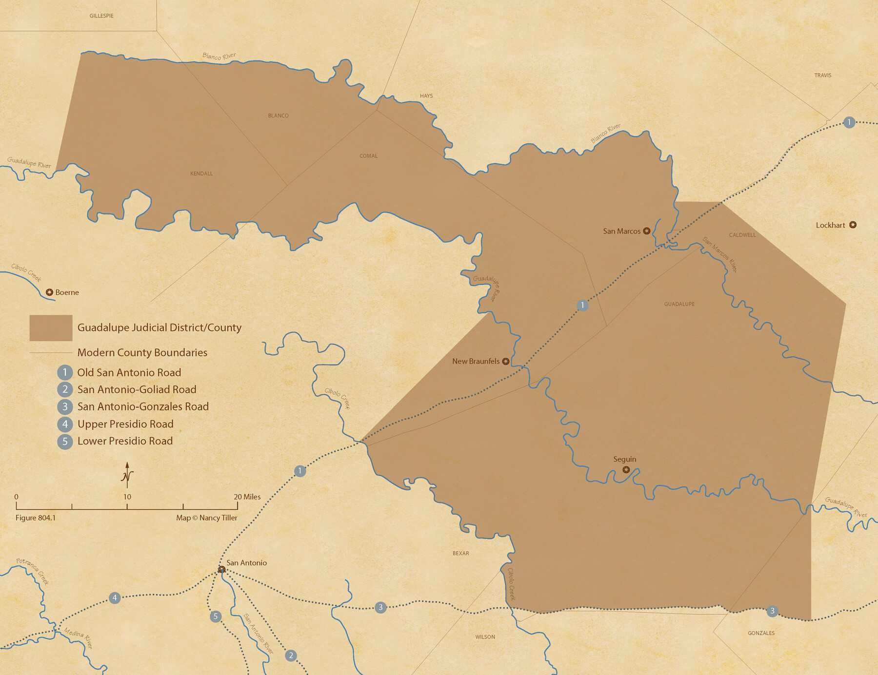
The Judicial District/County of Guadalupe. Created, January 29, 1842
Figure No. 804.1 from 'A Boundary Atlas of Texas, 1821-1845' by Jim Tiller
-
Map/Doc
96327
-
Collection
Nancy and Jim Tiller Digital Collection
-
Object Dates
2020/1/1 (Creation Date)
-
People and Organizations
Jim Tiller (Author)
Nancy Tiller (Cartographer)
Gang Gong (GIS Professional)
-
Subjects
Atlas Republic of Texas Texas Boundaries
-
Height x Width
16.7 x 21.7 inches
42.4 x 55.1 cm
-
Medium
digital image
-
Comments
To purchase a digital PDF copy of "A Boundary Atlas of Texas, 1821-1845" see 96437.
Part of: Nancy and Jim Tiller Digital Collection
The Mexican Municipality of San Patricio. April 1834

Print $20.00
The Mexican Municipality of San Patricio. April 1834
2020
Size 16.0 x 21.7 inches
Map/Doc 96034

The Republic County of Milam. November 28, 1839

Print $20.00
The Republic County of Milam. November 28, 1839
2020
Size 17.4 x 21.6 inches
Map/Doc 96228
The Republic County of Colorado. January 29, 1842

Print $20.00
The Republic County of Colorado. January 29, 1842
2020
Size 18.4 x 21.7 inches
Map/Doc 96125
Austin Empresario Colony. April 27, 1825

Print $20.00
Austin Empresario Colony. April 27, 1825
2020
Size 18.1 x 21.6 inches
Map/Doc 95979
The Republic County of Washington. January 15, 1842

Print $20.00
The Republic County of Washington. January 15, 1842
2020
Size 11.8 x 21.7 inches
Map/Doc 96306
Burnet Empresario Colony. December 22, 1826

Print $20.00
Burnet Empresario Colony. December 22, 1826
2020
Size 12.9 x 21.6 inches
Map/Doc 95985
The Republic County of Liberty. January 20, 1841

Print $20.00
The Republic County of Liberty. January 20, 1841
2020
Size 19.9 x 21.7 inches
Map/Doc 96209
The Republic County of Colorado. December 29, 1845

Print $20.00
The Republic County of Colorado. December 29, 1845
2020
Size 18.4 x 21.7 inches
Map/Doc 96127
The Mexican Municipality of Mina. Created, April 1834

Print $20.00
The Mexican Municipality of Mina. Created, April 1834
2020
Size 10.7 x 21.7 inches
Map/Doc 96028
The Republic County of Milam. January 29, 1842

Print $20.00
The Republic County of Milam. January 29, 1842
2020
Size 17.4 x 21.6 inches
Map/Doc 96231
The Republic County of Harrison. December 31, 1844

Print $20.00
The Republic County of Harrison. December 31, 1844
2020
Size 18.6 x 21.7 inches
Map/Doc 96176
You may also like

Concho County Boundary File 3

Print $10.00
- Digital $50.00
Concho County Boundary File 3
Size 8.5 x 3.9 inches
Map/Doc 51820
Concho County Rolled Sketch 24

Print $20.00
- Digital $50.00
Concho County Rolled Sketch 24
1964
Size 27.5 x 36.9 inches
Map/Doc 5557
El Paso County Rolled Sketch LH

Print $20.00
- Digital $50.00
El Paso County Rolled Sketch LH
1890
Size 20.3 x 31.7 inches
Map/Doc 5858
Flight Mission No. CRC-2R, Frame 178, Chambers County

Print $20.00
- Digital $50.00
Flight Mission No. CRC-2R, Frame 178, Chambers County
1956
Size 18.6 x 22.4 inches
Map/Doc 84756
[Capitol Leagues 217-228, 238, and vicinity]
![90672, [Capitol Leagues 217-228, 238, and vicinity], Twichell Survey Records](https://historictexasmaps.com/wmedia_w700/maps/90672-1.tif.jpg)
Print $20.00
- Digital $50.00
[Capitol Leagues 217-228, 238, and vicinity]
Size 23.0 x 9.9 inches
Map/Doc 90672
Nacogdoches County Working Sketch 9

Print $20.00
- Digital $50.00
Nacogdoches County Working Sketch 9
1967
Size 27.6 x 32.1 inches
Map/Doc 71225

Webb County Sketch File 72

Print $24.00
- Digital $50.00
Webb County Sketch File 72
2011
Size 11.0 x 8.5 inches
Map/Doc 90054
McMullen County Working Sketch 24

Print $20.00
- Digital $50.00
McMullen County Working Sketch 24
1950
Size 31.5 x 31.0 inches
Map/Doc 70725
Hardin County Rolled Sketch 23

Print $20.00
- Digital $50.00
Hardin County Rolled Sketch 23
1982
Size 28.5 x 45.2 inches
Map/Doc 6091
North end of Brazos Island

Print $20.00
- Digital $50.00
North end of Brazos Island
Size 25.9 x 18.2 inches
Map/Doc 72917