Brazoria County Rolled Sketch 49
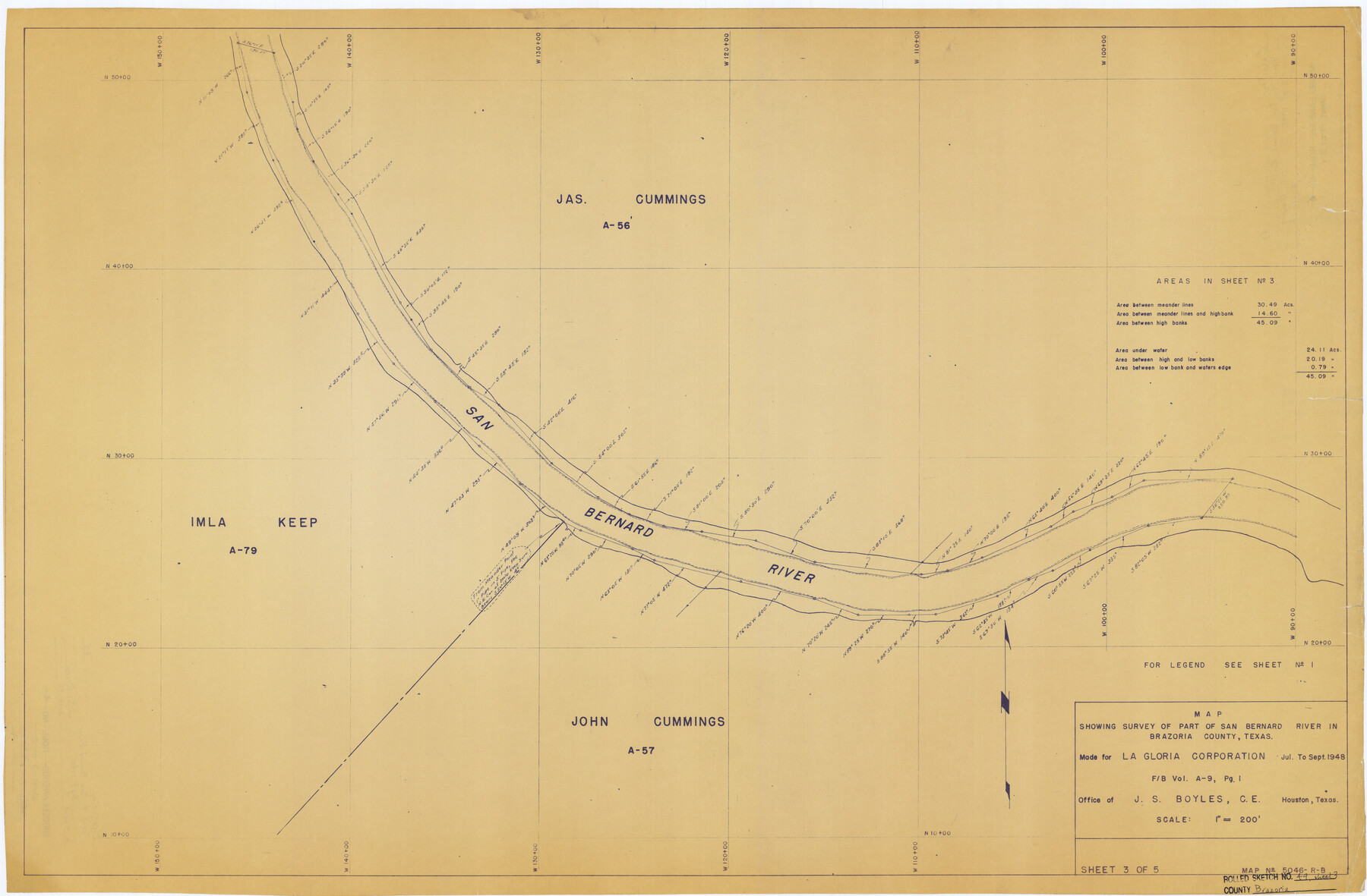
Map showing survey of part of San Bernard River in Brazoria County, Texas - Sheet 3 of 5
Miscellaneous Roll No. 4
-
Map/Doc
5184
-
Collection
General Map Collection
-
Object Dates
1948 (Creation Date)
1976/2/12 (File Date)
-
People and Organizations
J.S. Boyles (Surveyor/Engineer)
-
Counties
Brazoria
-
Subjects
Surveying Rolled Sketch
-
Height x Width
23.8 x 36.2 inches
60.5 x 91.9 cm
-
Medium
blueprint/diazo
-
Scale
1" = 200'
-
Comments
See 5182, 5183, 5185, and 5186 for other sheets and Brazoria County Sketch File 43 (15059) for report.
Related maps
Brazoria County Sketch File 43

Print $18.00
- Digital $50.00
Brazoria County Sketch File 43
1949
Size 14.5 x 9.0 inches
Map/Doc 15059
Brazoria County Rolled Sketch 49

Print $20.00
- Digital $50.00
Brazoria County Rolled Sketch 49
1948
Size 23.8 x 36.1 inches
Map/Doc 5182
Brazoria County Rolled Sketch 49

Print $20.00
- Digital $50.00
Brazoria County Rolled Sketch 49
1948
Size 23.7 x 36.3 inches
Map/Doc 5183
Brazoria County Rolled Sketch 49

Print $20.00
- Digital $50.00
Brazoria County Rolled Sketch 49
1948
Size 23.8 x 36.0 inches
Map/Doc 5185
Brazoria County Rolled Sketch 49

Print $20.00
- Digital $50.00
Brazoria County Rolled Sketch 49
1948
Size 24.1 x 36.5 inches
Map/Doc 5186
Part of: General Map Collection
Galveston County NRC Article 33.136 Sketch 94

Print $72.00
Galveston County NRC Article 33.136 Sketch 94
2024
Map/Doc 97293
Milam County Working Sketch 12

Print $40.00
- Digital $50.00
Milam County Working Sketch 12
Size 44.3 x 56.4 inches
Map/Doc 71027
Armstrong County Rolled Sketch B1

Print $20.00
- Digital $50.00
Armstrong County Rolled Sketch B1
1903
Size 25.8 x 37.8 inches
Map/Doc 5085
Nueces County NRC Article 33.136 Location Key Sheet

Print $20.00
- Digital $50.00
Nueces County NRC Article 33.136 Location Key Sheet
1975
Size 27.0 x 23.0 inches
Map/Doc 77032
Correct map of the Chicago, Burlington and Quincy Rail Road and its principal connecting lines

Print $20.00
- Digital $50.00
Correct map of the Chicago, Burlington and Quincy Rail Road and its principal connecting lines
1881
Size 27.7 x 38.6 inches
Map/Doc 93956
Flight Mission No. CUG-3P, Frame 15, Kleberg County

Print $20.00
- Digital $50.00
Flight Mission No. CUG-3P, Frame 15, Kleberg County
1956
Size 18.8 x 22.4 inches
Map/Doc 86225
Garza County Working Sketch 16

Print $20.00
- Digital $50.00
Garza County Working Sketch 16
1994
Size 21.7 x 40.3 inches
Map/Doc 63163
Flight Mission No. DQN-6K, Frame 5, Calhoun County

Print $20.00
- Digital $50.00
Flight Mission No. DQN-6K, Frame 5, Calhoun County
1953
Size 18.6 x 22.1 inches
Map/Doc 84427
Map of Zapata County

Print $20.00
- Digital $50.00
Map of Zapata County
1879
Size 27.4 x 25.6 inches
Map/Doc 4176
St. L. S-W. Ry. of Texas Map of Lufkin Branch in Cherokee County Texas

Print $40.00
- Digital $50.00
St. L. S-W. Ry. of Texas Map of Lufkin Branch in Cherokee County Texas
1912
Size 23.4 x 121.6 inches
Map/Doc 64016
Travis County Rolled Sketch 30

Print $20.00
- Digital $50.00
Travis County Rolled Sketch 30
1943
Size 26.5 x 25.6 inches
Map/Doc 8032
Flight Mission No. DIX-10P, Frame 171, Aransas County

Print $20.00
- Digital $50.00
Flight Mission No. DIX-10P, Frame 171, Aransas County
1956
Size 18.8 x 22.3 inches
Map/Doc 83961
You may also like
Sketch C Showing the Progress of the Survey in Section III From 1843 to 1852

Print $20.00
- Digital $50.00
Sketch C Showing the Progress of the Survey in Section III From 1843 to 1852
1852
Size 36.2 x 25.6 inches
Map/Doc 97201
A Topographical Map of the Government Tract Adjoining the City of Austin

Print $20.00
- Digital $50.00
A Topographical Map of the Government Tract Adjoining the City of Austin
1840
Size 41.9 x 37.4 inches
Map/Doc 4842
King County Sketch File 7

Print $72.00
- Digital $50.00
King County Sketch File 7
1901
Size 11.1 x 8.5 inches
Map/Doc 29030
Flight Mission No. DAG-24K, Frame 36, Matagorda County

Print $20.00
- Digital $50.00
Flight Mission No. DAG-24K, Frame 36, Matagorda County
1953
Size 18.5 x 22.2 inches
Map/Doc 86523
Real County Working Sketch 40

Print $20.00
- Digital $50.00
Real County Working Sketch 40
1952
Size 31.5 x 22.5 inches
Map/Doc 71932
Washington County Working Sketch 3

Print $20.00
- Digital $50.00
Washington County Working Sketch 3
1992
Size 31.5 x 42.7 inches
Map/Doc 72364
Flight Mission No. DCL-4C, Frame 121, Kenedy County

Print $20.00
- Digital $50.00
Flight Mission No. DCL-4C, Frame 121, Kenedy County
1943
Size 18.6 x 22.3 inches
Map/Doc 85820
Controlled Mosaic by Jack Amman Photogrammetric Engineers, Inc - Sheet 2

Print $20.00
- Digital $50.00
Controlled Mosaic by Jack Amman Photogrammetric Engineers, Inc - Sheet 2
1954
Size 20.0 x 24.0 inches
Map/Doc 83446
Jefferson County Sketch File 46

Print $20.00
- Digital $50.00
Jefferson County Sketch File 46
1933
Size 20.8 x 31.2 inches
Map/Doc 11880
Val Verde County Working Sketch 85

Print $20.00
- Digital $50.00
Val Verde County Working Sketch 85
1973
Size 28.5 x 38.3 inches
Map/Doc 72220
The Texas and Pacific Ry. Co., Station Map, Loraine, Texas

Print $20.00
- Digital $50.00
The Texas and Pacific Ry. Co., Station Map, Loraine, Texas
Size 11.6 x 18.6 inches
Map/Doc 64683
El Paso County Rolled Sketch 16

Print $40.00
- Digital $50.00
El Paso County Rolled Sketch 16
1885
Size 21.5 x 52.0 inches
Map/Doc 8855