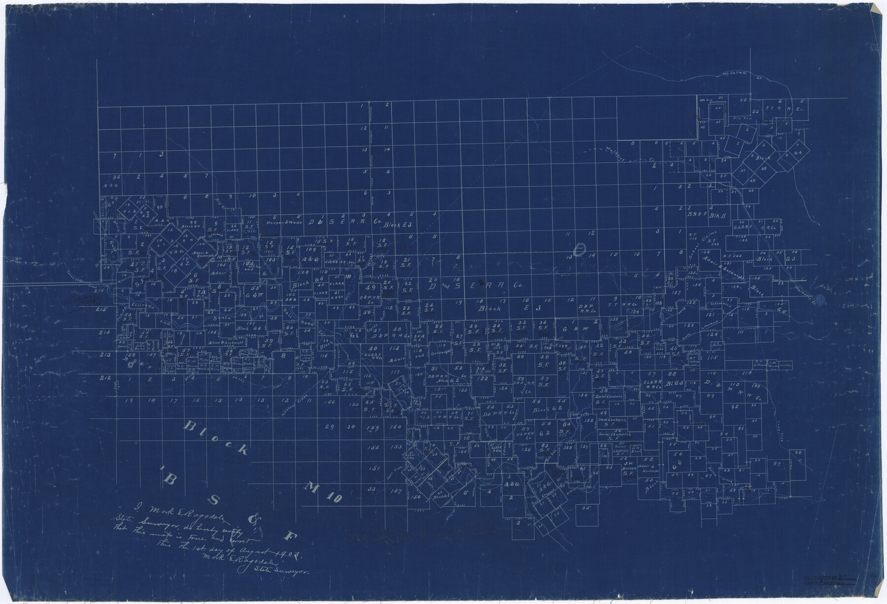
Armstrong County Rolled Sketch B1
[SW portion of Armstrong Co.]
-
Map/Doc
5085
-
Collection
General Map Collection
-
Object Dates
1903/8/1 (Creation Date)
-
People and Organizations
Mark E. Ragsdale (Surveyor/Engineer)
-
Counties
Armstrong
-
Subjects
Surveying Rolled Sketch
-
Height x Width
25.8 x 37.8 inches
65.5 x 96.0 cm
-
Medium
blueprint/diazo
-
Comments
For original sketch, see Armstrong County Rolled Sketch B (5084).
Related maps
Armstrong County Rolled Sketch B

Print $20.00
- Digital $50.00
Armstrong County Rolled Sketch B
1903
Size 25.9 x 37.0 inches
Map/Doc 5084
Part of: General Map Collection
Flight Mission No. DQN-1K, Frame 130, Calhoun County

Print $20.00
- Digital $50.00
Flight Mission No. DQN-1K, Frame 130, Calhoun County
1953
Size 18.5 x 22.1 inches
Map/Doc 84193
Nacogdoches County Boundary File 1

Print $36.00
- Digital $50.00
Nacogdoches County Boundary File 1
Size 6.7 x 4.4 inches
Map/Doc 57562

Sterling County Working Sketch 9

Print $20.00
- Digital $50.00
Sterling County Working Sketch 9
1980
Size 30.3 x 41.1 inches
Map/Doc 63991
Carte d'une partie de l'Asie, depuis la Mer Méditerranée jusqu'au Golfe de Cambaye dans la Mer de l'Inde

Print $20.00
- Digital $50.00
Carte d'une partie de l'Asie, depuis la Mer Méditerranée jusqu'au Golfe de Cambaye dans la Mer de l'Inde
1782
Size 12.9 x 18.0 inches
Map/Doc 97120
Galveston County Sketch File 61

Print $24.00
- Digital $50.00
Galveston County Sketch File 61
1988
Size 11.3 x 8.7 inches
Map/Doc 23653
Washington County Sketch File 5

Print $4.00
- Digital $50.00
Washington County Sketch File 5
Size 8.0 x 7.0 inches
Map/Doc 39652
[Sketch for Mineral Application 26501 - Sabine River, T. A. Oldhausen]
![2834, [Sketch for Mineral Application 26501 - Sabine River, T. A. Oldhausen], General Map Collection](https://historictexasmaps.com/wmedia_w700/maps/2834.tif.jpg)
Print $20.00
- Digital $50.00
[Sketch for Mineral Application 26501 - Sabine River, T. A. Oldhausen]
1931
Size 23.9 x 36.0 inches
Map/Doc 2834
Reeves County Rolled Sketch 2

Print $20.00
- Digital $50.00
Reeves County Rolled Sketch 2
1890
Size 34.0 x 39.5 inches
Map/Doc 9845

Brewster County Sketch File NS-11

Print $4.00
- Digital $50.00
Brewster County Sketch File NS-11
1948
Size 14.2 x 8.7 inches
Map/Doc 16218
Duval County Sketch File 17

Print $20.00
- Digital $50.00
Duval County Sketch File 17
1876
Size 19.0 x 17.8 inches
Map/Doc 11383
You may also like
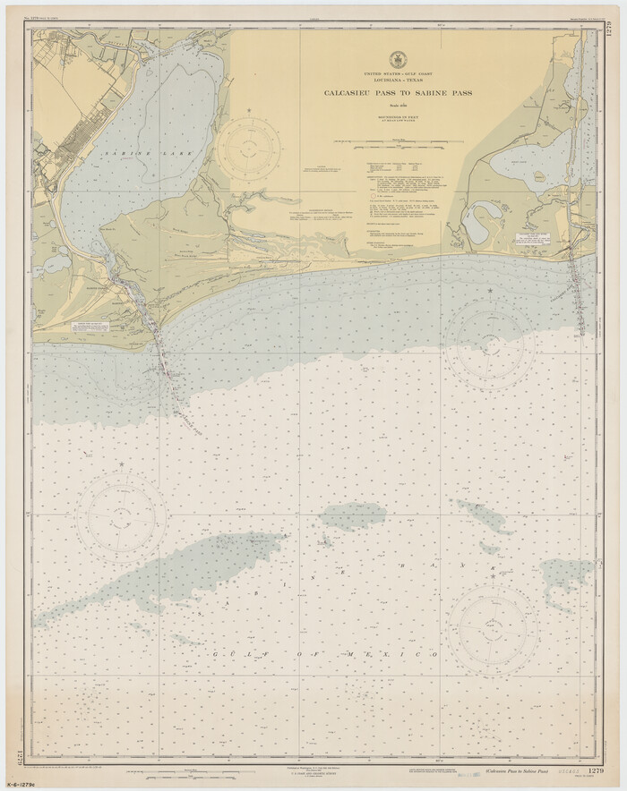
Calcasieu Pass to Sabine Pass
Print $20.00
- Digital $50.00
Calcasieu Pass to Sabine Pass
1950
Size 44.8 x 35.4 inches
Map/Doc 69808

Calhoun County Rolled Sketch 30

Print $20.00
- Digital $50.00
Calhoun County Rolled Sketch 30
1974
Size 18.5 x 27.6 inches
Map/Doc 5492
Kaufman County Working Sketch 5

Print $20.00
- Digital $50.00
Kaufman County Working Sketch 5
1922
Size 31.8 x 46.0 inches
Map/Doc 66668
Chambers County Rolled Sketch 34

Print $40.00
- Digital $50.00
Chambers County Rolled Sketch 34
1956
Size 50.0 x 85.8 inches
Map/Doc 73571
Wharton County Sketch File 10a

Print $20.00
- Digital $50.00
Wharton County Sketch File 10a
Size 11.0 x 19.0 inches
Map/Doc 12660
Navarro County Sketch File 20

Print $14.00
- Digital $50.00
Navarro County Sketch File 20
1967
Size 14.3 x 8.8 inches
Map/Doc 32343
[Strip along North line of Glasscock County School Land]
![90556, [Strip along North line of Glasscock County School Land], Twichell Survey Records](https://historictexasmaps.com/wmedia_w700/maps/90556-1.tif.jpg)
Print $2.00
- Digital $50.00
[Strip along North line of Glasscock County School Land]
Size 4.3 x 6.5 inches
Map/Doc 90556
Croquis del terro, camino, bosques, barrancas, cerro y beredas de Cerro-gordo con las posiciones de las topas Mejicanas y Americanas con sus respectivos Generales Cuerpos y Baterias el dis 18 de Abril de 1847

Print $20.00
Croquis del terro, camino, bosques, barrancas, cerro y beredas de Cerro-gordo con las posiciones de las topas Mejicanas y Americanas con sus respectivos Generales Cuerpos y Baterias el dis 18 de Abril de 1847
1847
Size 20.1 x 26.0 inches
Map/Doc 97343
Atascosa County Sketch File 6

Print $26.00
- Digital $50.00
Atascosa County Sketch File 6
Size 12.2 x 7.8 inches
Map/Doc 13752
Williamson County Working Sketch 5

Print $20.00
- Digital $50.00
Williamson County Working Sketch 5
1919
Size 23.4 x 18.3 inches
Map/Doc 72565
Map of Matagorda Bay and County, with the adjacent country

Print $20.00
- Digital $50.00
Map of Matagorda Bay and County, with the adjacent country
1846
Size 18.3 x 26.0 inches
Map/Doc 72765