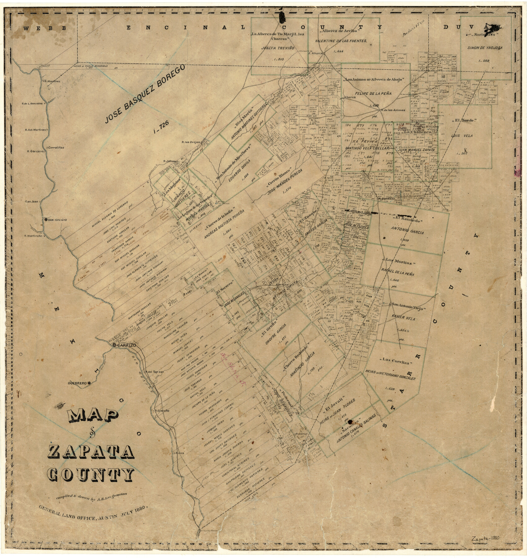
Map of Zapata County
-
Map/Doc
4176
-
Collection
General Map Collection
-
Object Dates
12/1879 (Creation Date)
-
People and Organizations
Texas General Land Office (Publisher)
A.B. Langermann (Compiler)
A.B. Langermann (Draftsman)
-
Counties
Zapata
-
Subjects
County
-
Height x Width
27.4 x 25.6 inches
69.6 x 65.0 cm
-
Features
Arroyo del Tigre
San Ignacio
Burro Creek
Laguna Hinojosena
Rancho Randado
Laguna del Guisache
Laguna Larga
Carrizo
Rio Salado
Rio Grande
Rancho del Teposan
Arroyo de Leon
Rancho Clareño
Arroyo Sacatosa
Arroyo Javali
Corralitas
Arroyo del Sandia
Las Morteros Creek
Rancho Martinez
Saladito Hill
Nogal Creek
Rancho Martineño
Rancho de los Animas
Laguna Guajolote
Rancho de Villa
Arroyo Veleño
Paso las Lajas
Rancho Barrosas
Arroyo del Poro
Rancho Jahury
Alberquito Springs
Alberca Creek
Rancho Alberca
Laguna de Hilario
Laguna de Zacatones
Laguna de Lobos
Alberca
Cañada de la Presa
Picacho Mountain
Arroyo Dolores
Rancho de L. Gonzales
Rancho Ant. Martinez
Rancho Garceno
Corralitas Ranch
Cañada de San Andres
Rancho las Ovejas
Banquitos Hill
Carrizo Road
Corpus Christi Road
Cañada del Coyote
Dry Creek
D. de los Comitas
Laguna Venado
Arroyo Blanco
Cabaceras Creek
Cerro Francisco
Puerta Creek
San Jose
Part of: General Map Collection
Zapata County Working Sketch 2

Print $20.00
- Digital $50.00
Zapata County Working Sketch 2
1930
Size 26.0 x 20.3 inches
Map/Doc 62053
Runnels County Sketch File 21A

Print $20.00
Runnels County Sketch File 21A
1886
Size 17.5 x 20.5 inches
Map/Doc 12256
Trinity River, Emhouse Sheet/Chambers Creek

Print $20.00
- Digital $50.00
Trinity River, Emhouse Sheet/Chambers Creek
1931
Size 35.8 x 35.3 inches
Map/Doc 65233
Flight Mission No. DQO-8K, Frame 17, Galveston County

Print $20.00
- Digital $50.00
Flight Mission No. DQO-8K, Frame 17, Galveston County
1952
Size 18.6 x 22.4 inches
Map/Doc 85140
Duval County Boundary File 1b

Print $48.00
- Digital $50.00
Duval County Boundary File 1b
1877
Size 12.6 x 8.0 inches
Map/Doc 52679
Polk County Sketch File 15

Print $8.00
- Digital $50.00
Polk County Sketch File 15
Size 12.7 x 8.4 inches
Map/Doc 34157
Dallam County Sketch File 15

Print $18.00
- Digital $50.00
Dallam County Sketch File 15
1990
Size 14.4 x 9.0 inches
Map/Doc 20381
Aransas County Sketch File 8

Print $4.00
- Digital $50.00
Aransas County Sketch File 8
Size 11.7 x 7.9 inches
Map/Doc 13114
Map of Ramon Musquiz Survey, Meanders of Lavaca & Navidad Rivers, Menefee & Redfish Lakes

Print $20.00
- Digital $50.00
Map of Ramon Musquiz Survey, Meanders of Lavaca & Navidad Rivers, Menefee & Redfish Lakes
1934
Size 23.0 x 18.6 inches
Map/Doc 65456
Wichita County Rolled Sketch 13

Print $20.00
- Digital $50.00
Wichita County Rolled Sketch 13
Size 25.7 x 16.6 inches
Map/Doc 8250
Flight Mission No. BQR-5K, Frame 61, Brazoria County

Print $20.00
- Digital $50.00
Flight Mission No. BQR-5K, Frame 61, Brazoria County
1952
Size 18.9 x 22.5 inches
Map/Doc 84006
Fayette County Sketch File 5

Print $4.00
- Digital $50.00
Fayette County Sketch File 5
Size 14.3 x 8.7 inches
Map/Doc 22506
You may also like
Harris County Working Sketch 18

Print $20.00
- Digital $50.00
Harris County Working Sketch 18
1919
Size 12.1 x 14.8 inches
Map/Doc 65910
Fort Bend County Sketch File 28

Print $40.00
- Digital $50.00
Fort Bend County Sketch File 28
Size 13.7 x 8.6 inches
Map/Doc 22979
[Surveys between the Sabine and Red Rivers made for titles under Radford Berry, Commissioner]
![14, [Surveys between the Sabine and Red Rivers made for titles under Radford Berry, Commissioner], General Map Collection](https://historictexasmaps.com/wmedia_w700/maps/14.tif.jpg)
Print $20.00
- Digital $50.00
[Surveys between the Sabine and Red Rivers made for titles under Radford Berry, Commissioner]
1835
Size 22.3 x 15.9 inches
Map/Doc 14
Harris County Working Sketch 108

Print $20.00
- Digital $50.00
Harris County Working Sketch 108
1981
Size 20.6 x 20.5 inches
Map/Doc 66000
Cuadro Historico-Geroglifico de la Peregrinacion de las Tribus Aztecas que Poblaron el Valle de Mexico (Num. 2)

Print $20.00
- Digital $50.00
Cuadro Historico-Geroglifico de la Peregrinacion de las Tribus Aztecas que Poblaron el Valle de Mexico (Num. 2)
Size 22.9 x 31.3 inches
Map/Doc 97012
[Corpus Christi Bay and Aransas Bay]
![144, [Corpus Christi Bay and Aransas Bay], General Map Collection](https://historictexasmaps.com/wmedia_w700/maps/144.tif.jpg)
Print $20.00
- Digital $50.00
[Corpus Christi Bay and Aransas Bay]
1840
Size 17.1 x 22.4 inches
Map/Doc 144
Panola County Working Sketch 26

Print $20.00
- Digital $50.00
Panola County Working Sketch 26
1958
Map/Doc 71435
Oldham and Hartley Counties Sketch

Print $20.00
- Digital $50.00
Oldham and Hartley Counties Sketch
1906
Size 16.1 x 17.1 inches
Map/Doc 90671
The Republic County of Houston. February 2, 1842

Print $20.00
The Republic County of Houston. February 2, 1842
2020
Size 19.7 x 21.8 inches
Map/Doc 96181
Bexar County Sketch File 43

Print $4.00
- Digital $50.00
Bexar County Sketch File 43
1882
Size 8.7 x 10.2 inches
Map/Doc 14522
[St. L. S-W. Ry. of Texas Map of Lufkin Branch in Cherokee County Texas]
![64018, [St. L. S-W. Ry. of Texas Map of Lufkin Branch in Cherokee County Texas], General Map Collection](https://historictexasmaps.com/wmedia_w700/maps/64018.tif.jpg)
Print $40.00
- Digital $50.00
[St. L. S-W. Ry. of Texas Map of Lufkin Branch in Cherokee County Texas]
1912
Size 22.3 x 121.1 inches
Map/Doc 64018
Proceedings of the International Boundary Commission, United States and Mexico, American Section, Elimination of Bancos, Treaty of 1905

Proceedings of the International Boundary Commission, United States and Mexico, American Section, Elimination of Bancos, Treaty of 1905
Size 12.4 x 9.6 inches
Map/Doc 83125