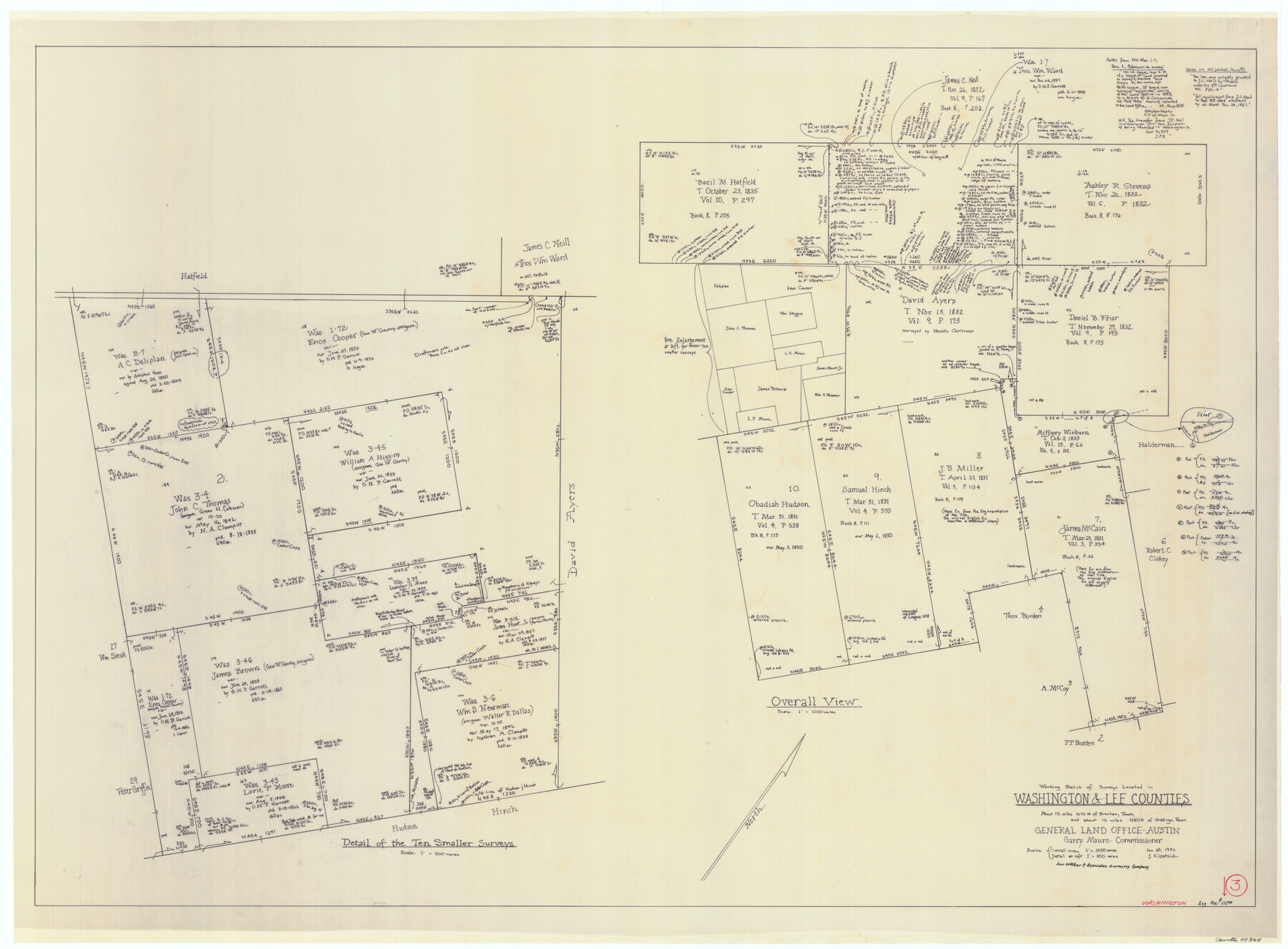
Washington County Working Sketch 3
-
Map/Doc
72364
-
Collection
General Map Collection
-
Object Dates
1/20/1992 (Creation Date)
-
People and Organizations
Joan Kilpatrick (Draftsman)
-
Counties
Washington Lee
-
Subjects
Surveying Working Sketch
-
Height x Width
31.5 x 42.7 inches
80.0 x 108.5 cm
-
Scale
1" = 1000 varas
Part of: General Map Collection
Current Miscellaneous File 50

Print $30.00
- Digital $50.00
Current Miscellaneous File 50
Size 11.9 x 9.2 inches
Map/Doc 74014
San Jacinto County Rolled Sketch 16

Print $20.00
- Digital $50.00
San Jacinto County Rolled Sketch 16
Size 10.7 x 17.6 inches
Map/Doc 93727

Marion County Working Sketch 41

Print $40.00
- Digital $50.00
Marion County Working Sketch 41
1996
Size 34.0 x 48.5 inches
Map/Doc 70817
Flight Mission No. DCL-4C, Frame 148, Kenedy County

Print $20.00
- Digital $50.00
Flight Mission No. DCL-4C, Frame 148, Kenedy County
1943
Size 18.6 x 22.5 inches
Map/Doc 85826
Hemphill County Working Sketch 6

Print $20.00
- Digital $50.00
Hemphill County Working Sketch 6
1950
Size 20.3 x 27.0 inches
Map/Doc 66101
Kaufman County Working Sketch 8

Print $20.00
- Digital $50.00
Kaufman County Working Sketch 8
1987
Size 35.7 x 42.3 inches
Map/Doc 66671
Erath County Sketch File 28

Print $40.00
- Digital $50.00
Erath County Sketch File 28
1895
Size 16.5 x 12.0 inches
Map/Doc 22309
Map of Cherokee Co.

Print $40.00
- Digital $50.00
Map of Cherokee Co.
1902
Size 49.6 x 39.7 inches
Map/Doc 4908
Newton County Sketch File 42

Print $39.00
- Digital $50.00
Newton County Sketch File 42
1936
Size 13.2 x 8.7 inches
Map/Doc 32425
Erath County Working Sketch 2

Print $20.00
- Digital $50.00
Erath County Working Sketch 2
Size 18.0 x 22.6 inches
Map/Doc 69083
Hunt County Sketch File 37

Print $4.00
- Digital $50.00
Hunt County Sketch File 37
Size 11.4 x 8.1 inches
Map/Doc 27155
You may also like
Sterling County

Print $20.00
- Digital $50.00
Sterling County
1971
Size 44.7 x 33.4 inches
Map/Doc 73294
Gray's New Map of Texas and the Indian Territory

Print $20.00
- Digital $50.00
Gray's New Map of Texas and the Indian Territory
1876
Size 17.6 x 28.6 inches
Map/Doc 97282
Morris County Rolled Sketch 2A

Print $20.00
- Digital $50.00
Morris County Rolled Sketch 2A
Size 24.3 x 19.1 inches
Map/Doc 10242
Upton County Working Sketch 47

Print $20.00
- Digital $50.00
Upton County Working Sketch 47
1973
Size 24.8 x 26.7 inches
Map/Doc 69543
Brewster County Working Sketch 108

Print $20.00
- Digital $50.00
Brewster County Working Sketch 108
1981
Size 37.7 x 47.6 inches
Map/Doc 67708
Working Sketch in Matagorda County

Print $20.00
- Digital $50.00
Working Sketch in Matagorda County
1890
Size 36.6 x 22.7 inches
Map/Doc 4479
Jackson County Rolled Sketch 3B

Print $20.00
- Digital $50.00
Jackson County Rolled Sketch 3B
1913
Size 23.7 x 21.8 inches
Map/Doc 6338
Harris County Historic Topographic 35

Print $20.00
- Digital $50.00
Harris County Historic Topographic 35
1915
Size 19.6 x 23.6 inches
Map/Doc 65846
Flight Mission No. BRA-16M, Frame 178, Jefferson County

Print $20.00
- Digital $50.00
Flight Mission No. BRA-16M, Frame 178, Jefferson County
1953
Size 18.6 x 22.4 inches
Map/Doc 85776
Chambers County Sketch File 53

Print $12.00
- Digital $50.00
Chambers County Sketch File 53
1952
Size 14.3 x 8.9 inches
Map/Doc 18087
Flight Mission No. CRC-3R, Frame 40, Chambers County

Print $20.00
- Digital $50.00
Flight Mission No. CRC-3R, Frame 40, Chambers County
1956
Size 18.6 x 22.3 inches
Map/Doc 84813
Greer County Sketch File 9

Print $6.00
- Digital $50.00
Greer County Sketch File 9
Size 15.9 x 11.4 inches
Map/Doc 24528