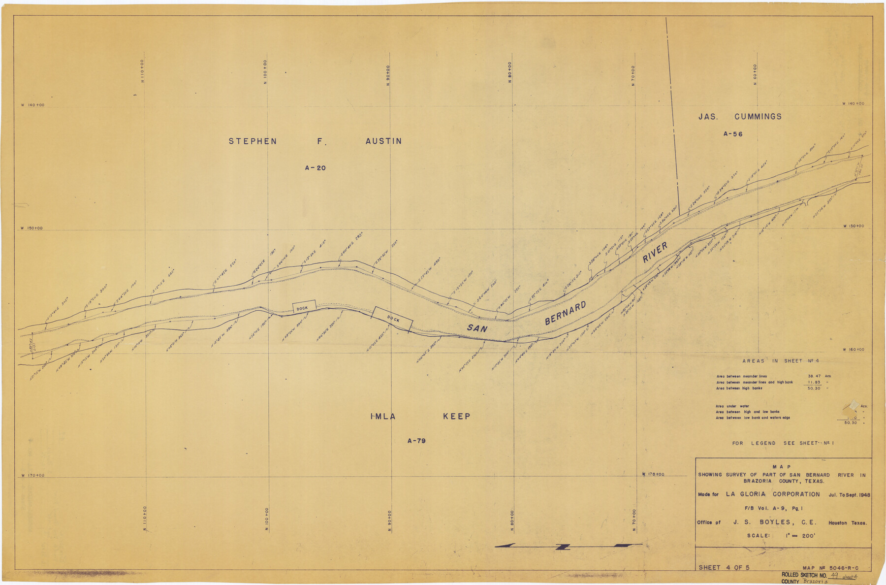
Brazoria County Rolled Sketch 49
Map showing survey of part of San Bernard River in Brazoria County, Texas - Sheet 4 of 5
Miscellaneous Roll No. 4
-
Map/Doc
5185
-
Collection
General Map Collection
-
Object Dates
1948 (Creation Date)
1976/2/12 (File Date)
-
People and Organizations
J.S. Boyles (Surveyor/Engineer)
-
Counties
Brazoria
-
Subjects
Surveying Rolled Sketch
-
Height x Width
23.8 x 36.0 inches
60.5 x 91.4 cm
-
Medium
blueprint/diazo
-
Scale
1" = 200'
-
Comments
See 5182, 5183, 5184, and 5186 for other sheets and Brazoria County Sketch File 43 (15059) for report.
Related maps
Brazoria County Sketch File 43

Print $18.00
- Digital $50.00
Brazoria County Sketch File 43
1949
Size 14.5 x 9.0 inches
Map/Doc 15059
Brazoria County Rolled Sketch 49

Print $20.00
- Digital $50.00
Brazoria County Rolled Sketch 49
1948
Size 23.8 x 36.1 inches
Map/Doc 5182
Brazoria County Rolled Sketch 49

Print $20.00
- Digital $50.00
Brazoria County Rolled Sketch 49
1948
Size 23.7 x 36.3 inches
Map/Doc 5183
Brazoria County Rolled Sketch 49

Print $20.00
- Digital $50.00
Brazoria County Rolled Sketch 49
1948
Size 23.8 x 36.2 inches
Map/Doc 5184
Brazoria County Rolled Sketch 49

Print $20.00
- Digital $50.00
Brazoria County Rolled Sketch 49
1948
Size 24.1 x 36.5 inches
Map/Doc 5186
Part of: General Map Collection
Val Verde County Working Sketch 54

Print $20.00
- Digital $50.00
Val Verde County Working Sketch 54
1956
Size 24.0 x 20.4 inches
Map/Doc 72189
Flight Mission No. DAG-2T, Frame 101, Matagorda County

Print $20.00
- Digital $50.00
Flight Mission No. DAG-2T, Frame 101, Matagorda County
1957
Size 18.6 x 18.3 inches
Map/Doc 86444
St. L. S-W. Ry. of Texas Map of Lufkin Branch in Cherokee County Texas

Print $40.00
- Digital $50.00
St. L. S-W. Ry. of Texas Map of Lufkin Branch in Cherokee County Texas
1912
Size 23.4 x 121.6 inches
Map/Doc 64016
[Gulf Coast of Texas]
![72703, [Gulf Coast of Texas], General Map Collection](https://historictexasmaps.com/wmedia_w700/maps/72703.tif.jpg)
Print $20.00
- Digital $50.00
[Gulf Coast of Texas]
1881
Size 28.9 x 18.2 inches
Map/Doc 72703
Smith County Working Sketch 1

Print $20.00
- Digital $50.00
Smith County Working Sketch 1
Size 16.3 x 13.0 inches
Map/Doc 63886
Potter County Boundary File 3f

Print $4.00
- Digital $50.00
Potter County Boundary File 3f
Size 6.3 x 4.4 inches
Map/Doc 57995
Texas, Corpus Christi Bay, Mustang Island

Print $40.00
- Digital $50.00
Texas, Corpus Christi Bay, Mustang Island
1940
Size 49.2 x 35.8 inches
Map/Doc 73461
Lamb County Boundary File 1

Print $10.00
- Digital $50.00
Lamb County Boundary File 1
Size 11.1 x 8.5 inches
Map/Doc 56027
Current Miscellaneous File 110

Print $62.00
- Digital $50.00
Current Miscellaneous File 110
1972
Size 11.1 x 8.8 inches
Map/Doc 74713
Real County Working Sketch 39

Print $20.00
- Digital $50.00
Real County Working Sketch 39
1951
Size 33.5 x 36.6 inches
Map/Doc 71931
Part of Laguna Madre in Kenedy and Willacy Counties, showing Subdivision for Mineral Development

Print $40.00
- Digital $50.00
Part of Laguna Madre in Kenedy and Willacy Counties, showing Subdivision for Mineral Development
1946
Size 49.1 x 30.0 inches
Map/Doc 1924
Presidio County Rolled Sketch 122

Print $20.00
- Digital $50.00
Presidio County Rolled Sketch 122
1981
Size 33.9 x 28.3 inches
Map/Doc 7395
You may also like
Frio County Sketch File 19

Print $20.00
- Digital $50.00
Frio County Sketch File 19
1963
Size 14.7 x 30.6 inches
Map/Doc 11519
General Highway Map, Fannin County, Texas

Print $20.00
General Highway Map, Fannin County, Texas
1940
Size 24.9 x 18.5 inches
Map/Doc 79087
Galveston Entrance

Print $20.00
- Digital $50.00
Galveston Entrance
1867
Size 18.4 x 22.1 inches
Map/Doc 69858
The Land Offices. No. 8, Mina, December 22, 1836

Print $20.00
The Land Offices. No. 8, Mina, December 22, 1836
2020
Size 19.9 x 21.7 inches
Map/Doc 96421
Travis County Working Sketch 43

Print $20.00
- Digital $50.00
Travis County Working Sketch 43
1974
Size 24.1 x 24.6 inches
Map/Doc 69427
Reeves County Working Sketch 6

Print $20.00
- Digital $50.00
Reeves County Working Sketch 6
1943
Size 14.1 x 18.4 inches
Map/Doc 63449
McMullen County Working Sketch 28

Print $20.00
- Digital $50.00
McMullen County Working Sketch 28
1954
Size 25.6 x 22.4 inches
Map/Doc 70729
[River Sections 54-73, part of Blk. GG]
![90317, [River Sections 54-73, part of Blk. GG], Twichell Survey Records](https://historictexasmaps.com/wmedia_w700/maps/90317-1.tif.jpg)
Print $20.00
- Digital $50.00
[River Sections 54-73, part of Blk. GG]
Size 37.0 x 35.9 inches
Map/Doc 90317
Haskell County Boundary File 1

Print $36.00
- Digital $50.00
Haskell County Boundary File 1
Size 8.7 x 9.0 inches
Map/Doc 54518
Andrews County Rolled Sketch 20

Print $20.00
- Digital $50.00
Andrews County Rolled Sketch 20
Size 31.6 x 40.0 inches
Map/Doc 8395
Brewster County Rolled Sketch 154

Print $20.00
- Digital $50.00
Brewster County Rolled Sketch 154
2001
Size 36.3 x 28.0 inches
Map/Doc 5325
Jefferson Co.

Print $40.00
- Digital $50.00
Jefferson Co.
1978
Size 49.3 x 43.5 inches
Map/Doc 95546