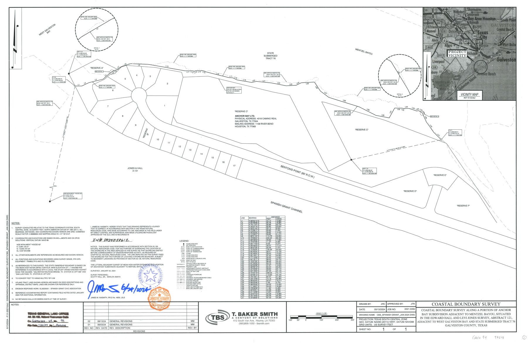
Galveston County NRC Article 33.136 Sketch 94
Coastal Boundary Survey along a portion of Anchor Bay Subdivision adjacent to Mentzel Bayou, situated in the Edward Hall and Levi Jones Survey, Abstract 121, adjacent to West Galveston Bay and State Submerged Tract 76
-
Map/Doc
97293
-
Collection
General Map Collection
-
Object Dates
6/24/2024 (Creation Date)
7/23/2024 (File Date)
1/30/2024 (Survey Date)
-
People and Organizations
James M. Naismith (Surveyor/Engineer)
-
Counties
Galveston
-
Subjects
Surveying CBS
-
Comments
Project: E Hall-Levi Jones-Anchor Bay Subdivision
GLO Project No.: SL20220051
Part of: General Map Collection
Starr County Sketch File 51

Print $22.00
- Digital $50.00
Starr County Sketch File 51
1967
Size 12.2 x 15.6 inches
Map/Doc 37009
Wise County Working Sketch 23

Print $20.00
- Digital $50.00
Wise County Working Sketch 23
1981
Size 43.6 x 36.9 inches
Map/Doc 72637
Blanco County Working Sketch 34
Print $40.00
- Digital $50.00
Blanco County Working Sketch 34
1978
Size 36.3 x 79.6 inches
Map/Doc 67394
Galveston Bay and Approaches

Print $20.00
- Digital $50.00
Galveston Bay and Approaches
1957
Size 43.6 x 32.7 inches
Map/Doc 69877
Val Verde County Sketch File 31

Print $18.00
- Digital $50.00
Val Verde County Sketch File 31
1922
Size 11.2 x 9.0 inches
Map/Doc 39240
Zavala County Sketch File 14

Print $26.00
- Digital $50.00
Zavala County Sketch File 14
1887
Size 14.4 x 8.7 inches
Map/Doc 41308
Webb County Boundary File 5

Print $165.00
- Digital $50.00
Webb County Boundary File 5
Size 14.2 x 8.8 inches
Map/Doc 59765
Crosby County Sketch File 24

Print $4.00
- Digital $50.00
Crosby County Sketch File 24
Size 7.3 x 8.8 inches
Map/Doc 20091
Navigation Maps of Gulf Intracoastal Waterway, Port Arthur to Brownsville, Texas

Print $4.00
- Digital $50.00
Navigation Maps of Gulf Intracoastal Waterway, Port Arthur to Brownsville, Texas
1951
Size 16.8 x 21.5 inches
Map/Doc 65437
Cass County Working Sketch 29

Print $20.00
- Digital $50.00
Cass County Working Sketch 29
1979
Size 38.4 x 23.5 inches
Map/Doc 67932
Duval County Sketch File 19b

Print $6.00
- Digital $50.00
Duval County Sketch File 19b
Size 15.4 x 9.7 inches
Map/Doc 21320
Jefferson County NRC Article 33.136 Location Key Sheet

Print $20.00
- Digital $50.00
Jefferson County NRC Article 33.136 Location Key Sheet
1970
Size 27.0 x 23.0 inches
Map/Doc 77028
You may also like
Nueces County Rolled Sketch 73

Print $20.00
- Digital $50.00
Nueces County Rolled Sketch 73
1981
Size 24.2 x 36.0 inches
Map/Doc 6931
[William T. Brewer, John R. Taylor, M. McDonald, W. N. Raymond, and surrounding surveys]
![91031, [William T. Brewer, John R. Taylor, M. McDonald, W. N. Raymond, and surrounding surveys], Twichell Survey Records](https://historictexasmaps.com/wmedia_w700/maps/91031-1.tif.jpg)
Print $20.00
- Digital $50.00
[William T. Brewer, John R. Taylor, M. McDonald, W. N. Raymond, and surrounding surveys]
Size 29.1 x 25.5 inches
Map/Doc 91031
Blanco County Sketch File 17

Print $4.00
- Digital $50.00
Blanco County Sketch File 17
Size 12.2 x 7.9 inches
Map/Doc 14592
Nueces County NRC Article 33.136 Sketch 17

Print $26.00
- Digital $50.00
Nueces County NRC Article 33.136 Sketch 17
2013
Size 18.0 x 24.0 inches
Map/Doc 94487
Calhoun County Rolled Sketch 30

Print $20.00
- Digital $50.00
Calhoun County Rolled Sketch 30
1974
Size 18.6 x 27.6 inches
Map/Doc 5495
Kenedy County Boundary File 1

Print $10.00
- Digital $50.00
Kenedy County Boundary File 1
Size 9.1 x 5.5 inches
Map/Doc 55777
Kinney County Working Sketch 33

Print $20.00
- Digital $50.00
Kinney County Working Sketch 33
1962
Size 39.0 x 44.2 inches
Map/Doc 70215
San Patricio County Rolled Sketch 29B

Print $20.00
- Digital $50.00
San Patricio County Rolled Sketch 29B
1936
Size 25.8 x 31.0 inches
Map/Doc 7582
Childress County Sketch File 11

Print $6.00
- Digital $50.00
Childress County Sketch File 11
Size 14.0 x 8.6 inches
Map/Doc 18253
Val Verde County Rolled Sketch 75

Print $20.00
- Digital $50.00
Val Verde County Rolled Sketch 75
1972
Size 28.9 x 40.6 inches
Map/Doc 8138
Old Miscellaneous File 39

Print $10.00
- Digital $50.00
Old Miscellaneous File 39
1893
Size 14.2 x 8.8 inches
Map/Doc 75284
Gulf of Mexico

Print $20.00
- Digital $50.00
Gulf of Mexico
1900
Size 18.2 x 28.0 inches
Map/Doc 72648