Brazoria County Rolled Sketch 49
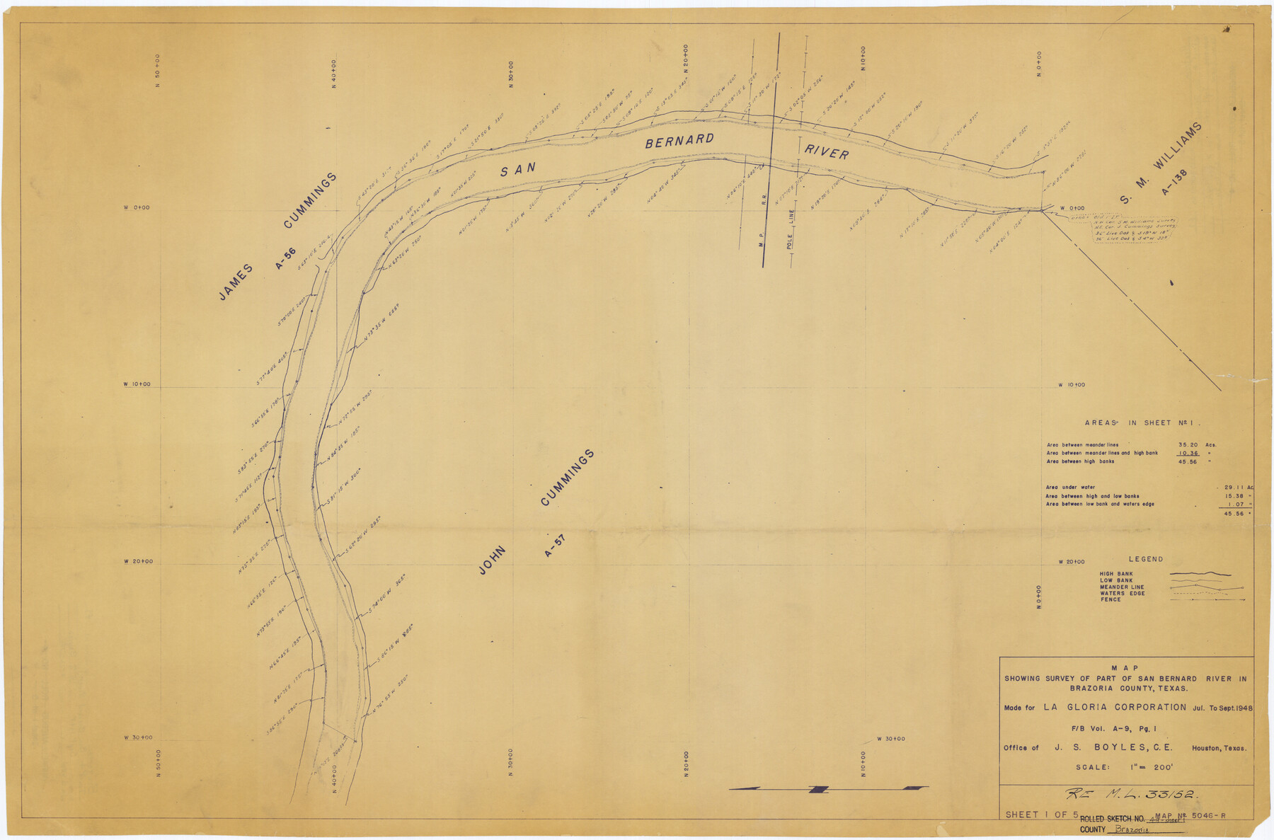
Map showing survey of part of San Bernard River in Brazoria County, Texas - Sheet 1 of 5
Miscellaneous Roll No. 4
-
Map/Doc
5182
-
Collection
General Map Collection
-
Object Dates
1948 (Creation Date)
1976/2/12 (File Date)
-
People and Organizations
J.S. Boyles (Surveyor/Engineer)
-
Counties
Brazoria
-
Subjects
Surveying Rolled Sketch
-
Height x Width
23.8 x 36.1 inches
60.5 x 91.7 cm
-
Medium
blueprint/diazo
-
Scale
1" = 200'
-
Comments
See 5183, 5184, 5185, and 5186 for other sheets and Brazoria County Sketch File 43 (15059) for report.
Related maps
Brazoria County Sketch File 43

Print $18.00
- Digital $50.00
Brazoria County Sketch File 43
1949
Size 14.5 x 9.0 inches
Map/Doc 15059
Brazoria County Rolled Sketch 49

Print $20.00
- Digital $50.00
Brazoria County Rolled Sketch 49
1948
Size 23.7 x 36.3 inches
Map/Doc 5183
Brazoria County Rolled Sketch 49

Print $20.00
- Digital $50.00
Brazoria County Rolled Sketch 49
1948
Size 23.8 x 36.2 inches
Map/Doc 5184
Brazoria County Rolled Sketch 49

Print $20.00
- Digital $50.00
Brazoria County Rolled Sketch 49
1948
Size 23.8 x 36.0 inches
Map/Doc 5185
Brazoria County Rolled Sketch 49

Print $20.00
- Digital $50.00
Brazoria County Rolled Sketch 49
1948
Size 24.1 x 36.5 inches
Map/Doc 5186
Part of: General Map Collection
Caney Cr. of East San Jacinto

Print $2.00
- Digital $50.00
Caney Cr. of East San Jacinto
Size 5.3 x 6.7 inches
Map/Doc 69745
Presidio County Working Sketch 110

Print $20.00
- Digital $50.00
Presidio County Working Sketch 110
1981
Size 38.7 x 32.2 inches
Map/Doc 71787
Outer Continental Shelf Leasing Maps (Louisiana Offshore Operations)

Print $20.00
- Digital $50.00
Outer Continental Shelf Leasing Maps (Louisiana Offshore Operations)
1954
Size 15.8 x 10.0 inches
Map/Doc 76109

Land Titles Issued in Stephen F. Austin's Colony

Print $20.00
Land Titles Issued in Stephen F. Austin's Colony
2015
Size 30.0 x 24.0 inches
Map/Doc 93754
Flight Mission No. CGI-3N, Frame 103, Cameron County

Print $20.00
- Digital $50.00
Flight Mission No. CGI-3N, Frame 103, Cameron County
1954
Size 18.4 x 22.2 inches
Map/Doc 84583
Galveston Bay, Texas

Print $20.00
- Digital $50.00
Galveston Bay, Texas
1905
Size 22.1 x 18.5 inches
Map/Doc 65389
Travis County Sketch File 5

Print $4.00
- Digital $50.00
Travis County Sketch File 5
Size 11.0 x 8.2 inches
Map/Doc 38281

San Saba County Working Sketch 4

Print $20.00
- Digital $50.00
San Saba County Working Sketch 4
1941
Size 43.4 x 31.8 inches
Map/Doc 63792
Liberty County Sketch File 13

Print $12.00
- Digital $50.00
Liberty County Sketch File 13
1858
Size 8.3 x 7.9 inches
Map/Doc 29909
Terrell County Rolled Sketch 46

Print $20.00
- Digital $50.00
Terrell County Rolled Sketch 46
1958
Size 16.1 x 14.6 inches
Map/Doc 7948
You may also like
Pecos County Working Sketch 42

Print $20.00
- Digital $50.00
Pecos County Working Sketch 42
1942
Size 31.3 x 23.9 inches
Map/Doc 71514
Duval County Rolled Sketch 25

Print $20.00
- Digital $50.00
Duval County Rolled Sketch 25
1944
Size 31.3 x 27.7 inches
Map/Doc 8813
The Newest Land Of Promise - The Pecos Valley in Texas

Print $20.00
- Digital $50.00
The Newest Land Of Promise - The Pecos Valley in Texas
1900
Size 17.8 x 22.9 inches
Map/Doc 97038
Dallas County Working Sketch 9

Print $20.00
- Digital $50.00
Dallas County Working Sketch 9
1960
Size 23.1 x 20.0 inches
Map/Doc 68575
Chambers County Working Sketch 5

Print $20.00
- Digital $50.00
Chambers County Working Sketch 5
1938
Size 20.9 x 31.6 inches
Map/Doc 67988
Houston County Working Sketch 12

Print $20.00
- Digital $50.00
Houston County Working Sketch 12
1956
Size 24.0 x 27.3 inches
Map/Doc 66242
McCulloch County Sketch File 2

Print $4.00
- Digital $50.00
McCulloch County Sketch File 2
1872
Size 12.8 x 8.1 inches
Map/Doc 31167
Marion County Working Sketch 18

Print $20.00
- Digital $50.00
Marion County Working Sketch 18
1957
Size 36.4 x 40.3 inches
Map/Doc 70794

Gaines County Working Sketch 4

Print $20.00
- Digital $50.00
Gaines County Working Sketch 4
1939
Size 44.5 x 43.1 inches
Map/Doc 69304
St. L. S-W. Ry. of Texas Map of Hillsboro Branch in Navarro County, Texas M.P. 621 to M.P. 648

Print $40.00
- Digital $50.00
St. L. S-W. Ry. of Texas Map of Hillsboro Branch in Navarro County, Texas M.P. 621 to M.P. 648
1913
Size 28.0 x 431.2 inches
Map/Doc 94016
Wilson County Working Sketch 14

Print $20.00
- Digital $50.00
Wilson County Working Sketch 14
1987
Size 31.9 x 36.2 inches
Map/Doc 72594