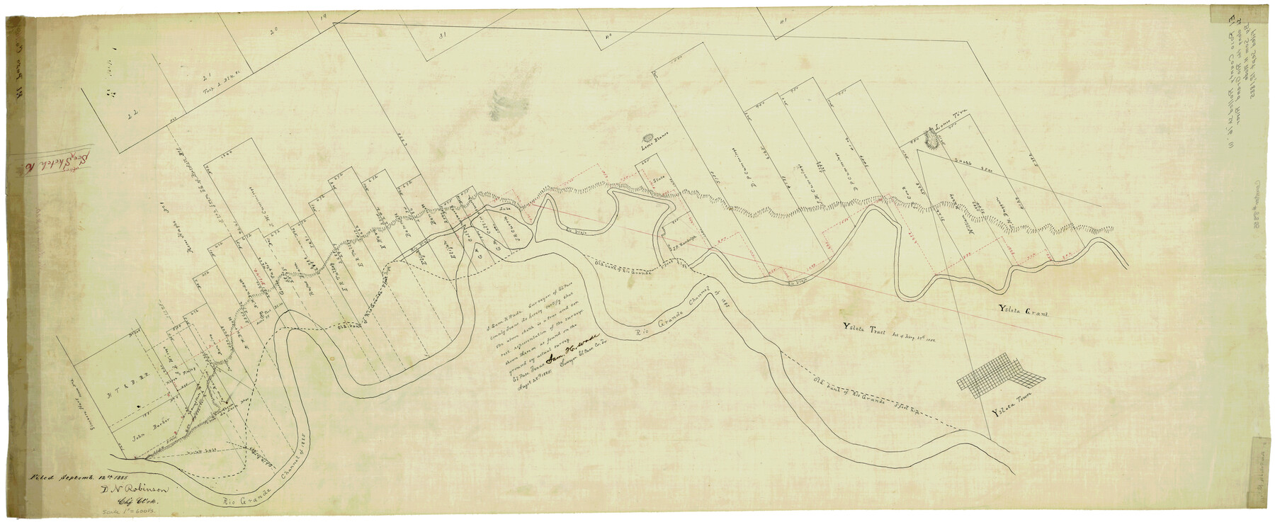
El Paso County Rolled Sketch 16
[Sketch along the Rio Grande]
-
Map/Doc
8855
-
Collection
General Map Collection
-
Object Dates
8/28/1885 (Creation Date)
9/12/1885 (File Date)
-
People and Organizations
Sam H. Wade (Surveyor/Engineer)
-
Counties
El Paso
-
Subjects
Surveying Rolled Sketch
-
Height x Width
21.5 x 52.0 inches
54.6 x 132.1 cm
-
Medium
linen, manuscript
-
Scale
1" = 600 varas
Part of: General Map Collection
Angelina County Sketch File 28

Print $22.00
- Digital $50.00
Angelina County Sketch File 28
1910
Size 15.7 x 12.0 inches
Map/Doc 13078

Mason County Working Sketch 5

Print $20.00
- Digital $50.00
Mason County Working Sketch 5
1935
Size 12.1 x 18.5 inches
Map/Doc 70841
Washington County Sketch File 3

Print $4.00
- Digital $50.00
Washington County Sketch File 3
1860
Size 8.1 x 9.2 inches
Map/Doc 39648
Edwards County Working Sketch 26

Print $20.00
- Digital $50.00
Edwards County Working Sketch 26
1942
Size 31.8 x 28.8 inches
Map/Doc 68902
Flight Mission No. CRC-3R, Frame 96, Chambers County

Print $20.00
- Digital $50.00
Flight Mission No. CRC-3R, Frame 96, Chambers County
1956
Size 18.7 x 22.4 inches
Map/Doc 84834
Motley County Sketch File DD (S)

Print $22.00
- Digital $50.00
Motley County Sketch File DD (S)
Size 10.9 x 7.1 inches
Map/Doc 32159
Hardin County Sketch File 10

Print $4.00
- Digital $50.00
Hardin County Sketch File 10
1862
Size 12.5 x 8.0 inches
Map/Doc 25110
Edwards County Working Sketch 42

Print $20.00
- Digital $50.00
Edwards County Working Sketch 42
1949
Size 25.5 x 31.4 inches
Map/Doc 68918
Hill County Sketch File 26

Print $12.00
- Digital $50.00
Hill County Sketch File 26
1892
Size 8.9 x 8.5 inches
Map/Doc 26522
Erath County Sketch File A2

Print $20.00
- Digital $50.00
Erath County Sketch File A2
Size 15.9 x 19.5 inches
Map/Doc 11464
King County Sketch File 6

Print $4.00
- Digital $50.00
King County Sketch File 6
Size 14.4 x 8.8 inches
Map/Doc 29026
You may also like
Grayson County Sketch File 20

Print $4.00
- Digital $50.00
Grayson County Sketch File 20
1861
Size 10.1 x 8.1 inches
Map/Doc 24493
Flight Mission No. DIX-3P, Frame 133, Aransas County

Print $20.00
- Digital $50.00
Flight Mission No. DIX-3P, Frame 133, Aransas County
1956
Size 17.8 x 21.1 inches
Map/Doc 83763
Jackson County Sketch File 25

Print $20.00
- Digital $50.00
Jackson County Sketch File 25
1942
Size 15.4 x 37.4 inches
Map/Doc 11845
The Pirson Colony. November 18, 1842

Print $20.00
The Pirson Colony. November 18, 1842
2020
Size 22.2 x 21.7 inches
Map/Doc 96370
Borden County Working Sketch 3

Print $20.00
- Digital $50.00
Borden County Working Sketch 3
1944
Size 21.3 x 23.5 inches
Map/Doc 67463

Map of North America

Print $20.00
- Digital $50.00
Map of North America
1720
Size 25.0 x 39.6 inches
Map/Doc 93823
[R. T. Bucy's Survey 3, League 321]
![91296, [R. T. Bucy's Survey 3, League 321], Twichell Survey Records](https://historictexasmaps.com/wmedia_w700/maps/91296-1.tif.jpg)
Print $20.00
- Digital $50.00
[R. T. Bucy's Survey 3, League 321]
Size 12.2 x 19.1 inches
Map/Doc 91296
Hockley County Working Sketch 4

Print $40.00
- Digital $50.00
Hockley County Working Sketch 4
1973
Size 38.7 x 52.3 inches
Map/Doc 66194
Jasper County Sketch File 19

Print $6.00
- Digital $50.00
Jasper County Sketch File 19
1890
Size 14.2 x 8.8 inches
Map/Doc 27815
Map of Crockett Co.

Print $20.00
- Digital $50.00
Map of Crockett Co.
1901
Size 33.9 x 45.8 inches
Map/Doc 66791
Flight Mission No. DIX-3P, Frame 135, Aransas County

Print $20.00
- Digital $50.00
Flight Mission No. DIX-3P, Frame 135, Aransas County
1956
Size 17.8 x 18.5 inches
Map/Doc 83765