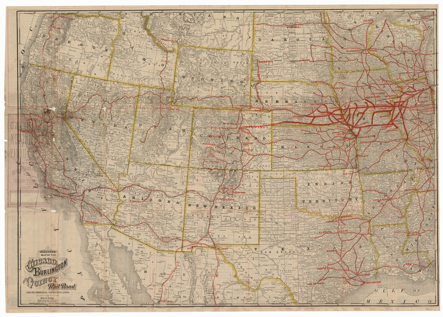
Correct map of the Chicago, Burlington and Quincy Rail Road and its principal connecting lines
-
Map/Doc
93956
-
Collection
General Map Collection
-
Object Dates
1881 (Creation Date)
2015/10/29 (File Date)
-
People and Organizations
Geo. F. Cram (Author)
-
Subjects
Railroads United States
-
Height x Width
27.7 x 38.6 inches
70.4 x 98.0 cm
-
Medium
paper, etching/engraving/lithograph
-
Comments
To view/download the time tables on verso, please click the "Download PDF" link above.
Part of: General Map Collection
Cottle County

Print $20.00
- Digital $50.00
Cottle County
1971
Size 43.4 x 36.0 inches
Map/Doc 95467
Flight Mission No. DAG-21K, Frame 88, Matagorda County

Print $20.00
- Digital $50.00
Flight Mission No. DAG-21K, Frame 88, Matagorda County
1952
Size 18.6 x 22.4 inches
Map/Doc 86417
Knox County Rolled Sketch 18

Print $20.00
- Digital $50.00
Knox County Rolled Sketch 18
1945
Size 23.1 x 29.5 inches
Map/Doc 6558
San Augustine County Working Sketch 3

Print $20.00
- Digital $50.00
San Augustine County Working Sketch 3
1934
Size 22.9 x 13.6 inches
Map/Doc 63690
Ramsey State Farm of the Texas Prison System, Brazoria County

Print $4.00
- Digital $50.00
Ramsey State Farm of the Texas Prison System, Brazoria County
1932
Size 15.9 x 18.6 inches
Map/Doc 65273
Bailey County Sketch File 21

Print $14.00
- Digital $50.00
Bailey County Sketch File 21
Size 11.3 x 8.8 inches
Map/Doc 13990
Historical Sketch of the Rebellion

Print $20.00
- Digital $50.00
Historical Sketch of the Rebellion
1863
Size 22.4 x 21.0 inches
Map/Doc 96618
Nueces County Rolled Sketch 63

Print $20.00
- Digital $50.00
Nueces County Rolled Sketch 63
1979
Size 25.5 x 38.1 inches
Map/Doc 6909
Young County Sketch File 18

Print $10.00
- Digital $50.00
Young County Sketch File 18
1929
Size 11.5 x 8.7 inches
Map/Doc 40882
Duval County Sketch File 65

Print $6.00
- Digital $50.00
Duval County Sketch File 65
1943
Size 14.4 x 9.1 inches
Map/Doc 21441
Tarrant County Sketch File 1a

Print $4.00
- Digital $50.00
Tarrant County Sketch File 1a
1851
Size 10.2 x 7.8 inches
Map/Doc 37670
Garza County Sketch File B

Print $20.00
- Digital $50.00
Garza County Sketch File B
1898
Size 19.3 x 29.4 inches
Map/Doc 11549
You may also like
[Surveys along Buffalo Bayou]
![153, [Surveys along Buffalo Bayou], General Map Collection](https://historictexasmaps.com/wmedia_w700/maps/153.tif.jpg)
Print $2.00
- Digital $50.00
[Surveys along Buffalo Bayou]
Size 6.3 x 3.9 inches
Map/Doc 153
[T. & P. Blocks 35 and 36, Township 4 North; Block I, Township 4 North]
![91297, [T. & P. Blocks 35 and 36, Township 4 North; Block I, Township 4 North], Twichell Survey Records](https://historictexasmaps.com/wmedia_w700/maps/91297-1.tif.jpg)
Print $20.00
- Digital $50.00
[T. & P. Blocks 35 and 36, Township 4 North; Block I, Township 4 North]
Size 19.3 x 22.2 inches
Map/Doc 91297
Blanco County Rolled Sketch 22

Print $20.00
- Digital $50.00
Blanco County Rolled Sketch 22
2007
Size 17.4 x 11.4 inches
Map/Doc 87926
Nueces County Rolled Sketch 24

Print $20.00
- Digital $50.00
Nueces County Rolled Sketch 24
Size 19.6 x 24.8 inches
Map/Doc 6873
Mapa de toda la Frontera de los dominios del Rey en la America septentrional

Print $40.00
Mapa de toda la Frontera de los dominios del Rey en la America septentrional
1771
Size 26.4 x 50.0 inches
Map/Doc 95311
Presidio County Sketch File 21

Print $4.00
- Digital $50.00
Presidio County Sketch File 21
1889
Size 14.2 x 8.7 inches
Map/Doc 34454

Dallas/Fort Worth Street Map & Visitor Guide

Dallas/Fort Worth Street Map & Visitor Guide
2000
Size 35.5 x 23.1 inches
Map/Doc 94296
Dimmit County Sketch File 24

Print $4.00
- Digital $50.00
Dimmit County Sketch File 24
1885
Size 13.0 x 8.7 inches
Map/Doc 21140
Lamar County State Real Property Sketch 1

Print $40.00
- Digital $50.00
Lamar County State Real Property Sketch 1
2013
Size 48.0 x 36.0 inches
Map/Doc 93662
[Map of Line Dividing Fannin and Nacogdoches Districts]
![3134, [Map of Line Dividing Fannin and Nacogdoches Districts], General Map Collection](https://historictexasmaps.com/wmedia_w700/maps/3134.tif.jpg)
Print $20.00
- Digital $50.00
[Map of Line Dividing Fannin and Nacogdoches Districts]
1850
Size 35.6 x 40.8 inches
Map/Doc 3134
Station Map, the Missouri, Kansas and Texas Ry. Of Texas - Henrietta Division

Print $20.00
- Digital $50.00
Station Map, the Missouri, Kansas and Texas Ry. Of Texas - Henrietta Division
1918
Size 11.8 x 26.7 inches
Map/Doc 64763