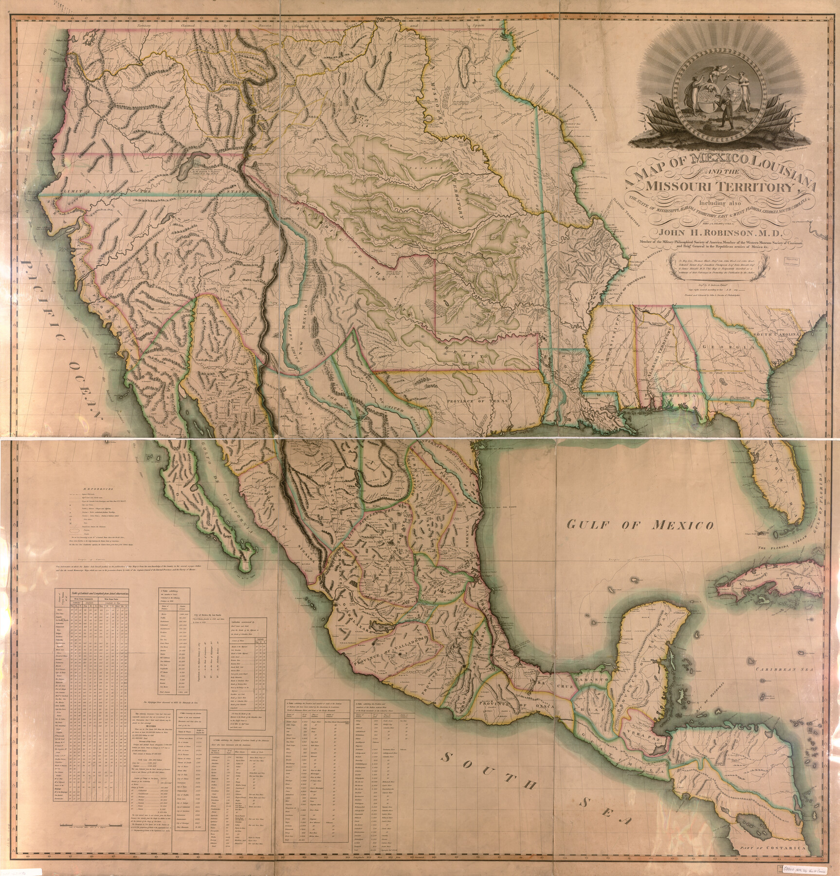
A Map of Mexico, Louisiana and the Missouri Territory, including also the State of Mississippi, Alabama Territory, East & West Florida, Georgia, South Carolina & part of the Island of Cuba
-
Map/Doc
95312
-
Collection
Library of Congress
-
Object Dates
1819 (Copyright Date)
-
People and Organizations
John L. Narstin (Publisher)
H. Anderson (Printer)
John H. Robinson (Cartographer)
Hugh Anderson (Engraver)
-
Subjects
Mexico Spanish Texas United States
-
Height x Width
66.9 x 64.2 inches
169.9 x 163.1 cm
-
Medium
digital image
-
Comments
Copied from a 1771 map. For more information see here. Prints available from the GLO courtesy of Library of Congress, Geography and Map Division.
Part of: Library of Congress
Railroad map of the state of Texas / compiled and engraved expressly for the American railroad manual.

Print $20.00
Railroad map of the state of Texas / compiled and engraved expressly for the American railroad manual.
1873
Size 13.4 x 9.5 inches
Map/Doc 93599
Palo Pinto County, Texas

Print $20.00
Palo Pinto County, Texas
Size 24.6 x 19.5 inches
Map/Doc 88986
Colton's new map of the state of Texas, the Indian Territory and adjoining portions of New Mexico, Louisiana, and Arkansas

Print $20.00
Colton's new map of the state of Texas, the Indian Territory and adjoining portions of New Mexico, Louisiana, and Arkansas
1872
Size 31.1 x 36.6 inches
Map/Doc 93579
Colton's rail road and county map of the southern states containing the latest information.

Print $20.00
Colton's rail road and county map of the southern states containing the latest information.
1864
Size 24.4 x 31.1 inches
Map/Doc 93570
Denison, Grayson County, Texas, 1891

Print $20.00
Denison, Grayson County, Texas, 1891
1891
Size 23.9 x 36.4 inches
Map/Doc 93480

Greenville, Tex., County Seat of Hunt County, 1886

Print $20.00
Greenville, Tex., County Seat of Hunt County, 1886
1886
Size 20.4 x 28.3 inches
Map/Doc 93476
From the Red River to the Rio Grande from explorations and surveys made under the direction of the Hon. Jefferson Davis, Secretary of War by Captain John Pope, Corps Topl. Engrs. assisted by Lieutenant Kenner Gerrard, 1st Dragoons, 1854-6

Print $40.00
From the Red River to the Rio Grande from explorations and surveys made under the direction of the Hon. Jefferson Davis, Secretary of War by Captain John Pope, Corps Topl. Engrs. assisted by Lieutenant Kenner Gerrard, 1st Dragoons, 1854-6
1859
Size 28.0 x 57.9 inches
Map/Doc 93581
General Chart of the Kingdom of New Spain betn. parallels of 16 & 38° N. from materials in Mexico at commencement of year of 1804

Print $20.00
General Chart of the Kingdom of New Spain betn. parallels of 16 & 38° N. from materials in Mexico at commencement of year of 1804
1804
Size 38.4 x 26.5 inches
Map/Doc 95310
![88956, Hood Co[unty], Library of Congress](https://historictexasmaps.com/wmedia_w700/maps/88956.tif.jpg)
Map showing the distribution of the slave population of the southern states of the United States. Compiled from the census of 1860

Print $20.00
Map showing the distribution of the slave population of the southern states of the United States. Compiled from the census of 1860
1861
Size 27.8 x 34.8 inches
Map/Doc 95749
[Map showing T&P Lands in El Paso County]
![88937, [Map showing T&P Lands in El Paso County], Library of Congress](https://historictexasmaps.com/wmedia_w700/maps/88937.tif.jpg)
Print $20.00
[Map showing T&P Lands in El Paso County]
Size 22.3 x 17.3 inches
Map/Doc 88937
You may also like
Aransas County NRC Article 33.136 Location Key Sheet

Print $20.00
- Digital $50.00
Aransas County NRC Article 33.136 Location Key Sheet
1975
Size 27.0 x 23.0 inches
Map/Doc 77004
Maverick County Sketch File 22

Print $32.00
- Digital $50.00
Maverick County Sketch File 22
1892
Size 5.5 x 6.3 inches
Map/Doc 31136
Briscoe County Rolled Sketch 9

Print $20.00
- Digital $50.00
Briscoe County Rolled Sketch 9
Size 30.6 x 21.4 inches
Map/Doc 5327
Station Map, the Missouri, Kansas and Texas Ry. Of Texas - Henrietta Division

Print $20.00
- Digital $50.00
Station Map, the Missouri, Kansas and Texas Ry. Of Texas - Henrietta Division
1918
Size 11.9 x 26.9 inches
Map/Doc 64765
[Worksheets related to the Wilson Strickland survey and vicinity]
![91282, [Worksheets related to the Wilson Strickland survey and vicinity], Twichell Survey Records](https://historictexasmaps.com/wmedia_w700/maps/91282-1.tif.jpg)
Print $20.00
- Digital $50.00
[Worksheets related to the Wilson Strickland survey and vicinity]
Size 7.9 x 24.3 inches
Map/Doc 91282
Ward County Sketch File 12

Print $4.00
- Digital $50.00
Ward County Sketch File 12
Size 14.3 x 8.8 inches
Map/Doc 39638
Carte d'une partie de la Syrie et de la Palestine

Print $20.00
- Digital $50.00
Carte d'une partie de la Syrie et de la Palestine
1782
Size 12.8 x 17.9 inches
Map/Doc 97121
Rand, McNally & Co.'s Texas

Print $20.00
- Digital $50.00
Rand, McNally & Co.'s Texas
1902
Size 21.3 x 28.4 inches
Map/Doc 95886
Flight Mission No. BRE-1P, Frame 139, Nueces County

Print $20.00
- Digital $50.00
Flight Mission No. BRE-1P, Frame 139, Nueces County
1956
Size 18.8 x 22.6 inches
Map/Doc 86699
Intracoastal Waterway, Houma, LA to Corpus Christi, TX

Print $5.00
- Digital $50.00
Intracoastal Waterway, Houma, LA to Corpus Christi, TX
Size 30.0 x 22.0 inches
Map/Doc 61911
Map of Concho County

Print $20.00
- Digital $50.00
Map of Concho County
1897
Size 46.9 x 38.4 inches
Map/Doc 4919
