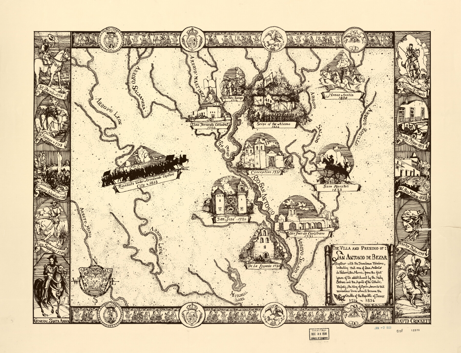
The Villa and Presidio of San Antonio de Bexar
-
Map/Doc
93564
-
Collection
Library of Congress
-
Object Dates
1935 (Creation Date)
-
People and Organizations
Fanita Lanier (Author)
-
Subjects
City
-
Height x Width
18.1 x 23.6 inches
46.0 x 59.9 cm
-
Comments
For more information see here. For Research Purposes Only.
Part of: Library of Congress
![88951, Haskell Co[unty], Library of Congress](https://historictexasmaps.com/wmedia_w700/maps/88951.tif.jpg)
Map of the River Sabine from its Mouth on the Gulf of Mexico in the Sea to Logan's Ferry in Latitude 31°58'24" north

Print $40.00
Map of the River Sabine from its Mouth on the Gulf of Mexico in the Sea to Logan's Ferry in Latitude 31°58'24" north
1840
Size 35.0 x 170.0 inches
Map/Doc 88901


City of Houston and Environs

Print $20.00
City of Houston and Environs
1895
Size 30.4 x 33.6 inches
Map/Doc 93486
Campaign map of Texas, Louisiana and Arkansas, showing all the battle fields and also the marches of Walker's Division. [1861-65]
![93567, Campaign map of Texas, Louisiana and Arkansas, showing all the battle fields and also the marches of Walker's Division. [1861-65], Library of Congress](https://historictexasmaps.com/wmedia_w700/maps/93567.tif.jpg)
Print $20.00
Campaign map of Texas, Louisiana and Arkansas, showing all the battle fields and also the marches of Walker's Division. [1861-65]
1871
Size 27.6 x 37.0 inches
Map/Doc 93567
New Map of Texas with the Contiguous American and Mexican States

Print $20.00
New Map of Texas with the Contiguous American and Mexican States
1835
Size 13.3 x 15.9 inches
Map/Doc 88894
![88940, Fisher Co[unty], Library of Congress](https://historictexasmaps.com/wmedia_w700/maps/88940.tif.jpg)
Map of Texas, showing the line of the Texas and New Orleans Rail Road, and its connections in the U.S. and adjacent territories.

Print $20.00
Map of Texas, showing the line of the Texas and New Orleans Rail Road, and its connections in the U.S. and adjacent territories.
1860
Size 22.0 x 31.1 inches
Map/Doc 93612
Denison, Texas, Grayson County 1886

Print $20.00
Denison, Texas, Grayson County 1886
1886
Size 21.1 x 30.5 inches
Map/Doc 93466
Pocket Map Showing the Railroads, Street Railways, Manufactories, Deep Water Connections, Blocks and Subdivisions of the City of Houston

Print $20.00
Pocket Map Showing the Railroads, Street Railways, Manufactories, Deep Water Connections, Blocks and Subdivisions of the City of Houston
1890
Size 35.5 x 29.8 inches
Map/Doc 93487
Hardeman Co[unty], Texas
![88946, Hardeman Co[unty], Texas, Library of Congress](https://historictexasmaps.com/wmedia_w700/maps/88946.tif.jpg)
Print $20.00
Hardeman Co[unty], Texas
1880
Size 27.8 x 23.7 inches
Map/Doc 88946
You may also like
The Dividing Link - Mexico & Central America

The Dividing Link - Mexico & Central America
Size 20.5 x 31.2 inches
Map/Doc 95941
Val Verde County Sketch File 53

Print $20.00
- Digital $50.00
Val Verde County Sketch File 53
1892
Size 45.0 x 16.2 inches
Map/Doc 10421
Map of Zapata County

Print $40.00
- Digital $50.00
Map of Zapata County
1901
Size 49.1 x 42.4 inches
Map/Doc 63144
Dimmit County Sketch File 9

Print $6.00
- Digital $50.00
Dimmit County Sketch File 9
Size 8.9 x 11.2 inches
Map/Doc 21070
Midland County Rolled Sketch 12

Print $40.00
- Digital $50.00
Midland County Rolled Sketch 12
Size 97.0 x 42.6 inches
Map/Doc 9520
Hood County Working Sketch 28

Print $20.00
- Digital $50.00
Hood County Working Sketch 28
1995
Size 17.5 x 11.4 inches
Map/Doc 66222
General Highway Map, Crane County, Texas

Print $20.00
General Highway Map, Crane County, Texas
1961
Size 24.8 x 18.2 inches
Map/Doc 79424
Cameron County NRC Article 33.136 Sketch 5

Print $202.00
- Digital $50.00
Cameron County NRC Article 33.136 Sketch 5
2018
Size 24.3 x 36.1 inches
Map/Doc 95724
Map of Granbury

Print $20.00
- Digital $50.00
Map of Granbury
1960
Size 23.5 x 26.7 inches
Map/Doc 3041
Hardeman County Aerial Photograph Index Sheet 3

Print $20.00
- Digital $50.00
Hardeman County Aerial Photograph Index Sheet 3
1950
Size 20.3 x 17.0 inches
Map/Doc 83699
Right of Way and Track Map, the Missouri, Kansas and Texas Ry. of Texas - Henrietta Division

Print $20.00
- Digital $50.00
Right of Way and Track Map, the Missouri, Kansas and Texas Ry. of Texas - Henrietta Division
1918
Size 11.8 x 26.8 inches
Map/Doc 64751
Pecos County Working Sketch 98

Print $20.00
- Digital $50.00
Pecos County Working Sketch 98
1970
Size 42.8 x 31.8 inches
Map/Doc 71571