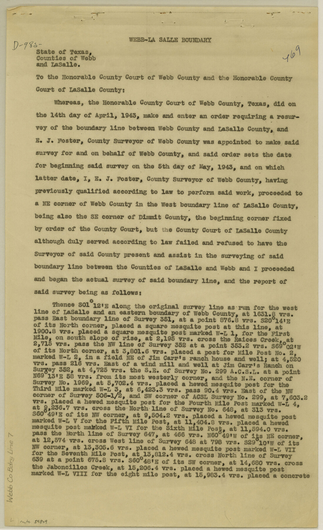
Webb County Boundary File 7
Part La Salle County W. Boundary Line and Webb Co. N. E. Boundary Also La Salle S. Boundry [sp.] Line and Part Webb Co. N. Line
-
Map/Doc
59809
-
Collection
General Map Collection
-
Counties
Webb
-
Subjects
County Boundaries
-
Height x Width
14.2 x 8.7 inches
36.1 x 22.1 cm
Part of: General Map Collection
Briscoe County Sketch File O

Print $40.00
- Digital $50.00
Briscoe County Sketch File O
Size 27.1 x 32.4 inches
Map/Doc 11013
Runnels County Sketch File 11

Print $8.00
Runnels County Sketch File 11
1883
Size 10.7 x 7.9 inches
Map/Doc 35452
Sutton County Working Sketch 63

Print $20.00
- Digital $50.00
Sutton County Working Sketch 63
1961
Size 26.0 x 29.9 inches
Map/Doc 62406
Flight Mission No. BRE-2P, Frame 49, Nueces County

Print $20.00
- Digital $50.00
Flight Mission No. BRE-2P, Frame 49, Nueces County
1956
Size 18.3 x 22.4 inches
Map/Doc 86751
FT. W. & R. G. Ry. Right of Way Map, Whiteland to Lightner, Concho County, Texas

Print $40.00
- Digital $50.00
FT. W. & R. G. Ry. Right of Way Map, Whiteland to Lightner, Concho County, Texas
1918
Size 37.5 x 68.4 inches
Map/Doc 61413
Flight Mission No. DQN-5K, Frame 23, Calhoun County

Print $20.00
- Digital $50.00
Flight Mission No. DQN-5K, Frame 23, Calhoun County
1953
Size 18.5 x 22.1 inches
Map/Doc 84374
Railroad Track Map, H&TCRRCo., Falls County, Texas

Print $4.00
- Digital $50.00
Railroad Track Map, H&TCRRCo., Falls County, Texas
1918
Size 11.7 x 18.4 inches
Map/Doc 62862
Jones County Working Sketch Graphic Index

Print $20.00
- Digital $50.00
Jones County Working Sketch Graphic Index
1921
Size 39.5 x 38.6 inches
Map/Doc 76599
Medina County Sketch File 7

Print $20.00
- Digital $50.00
Medina County Sketch File 7
Size 25.0 x 10.6 inches
Map/Doc 12067
Montague County Sketch File 6

Print $4.00
- Digital $50.00
Montague County Sketch File 6
1856
Size 8.0 x 8.4 inches
Map/Doc 31717
Flight Mission No. CRC-4R, Frame 184, Chambers County

Print $20.00
- Digital $50.00
Flight Mission No. CRC-4R, Frame 184, Chambers County
1956
Size 18.6 x 22.3 inches
Map/Doc 84935
Midland County Rolled Sketch 12

Print $40.00
- Digital $50.00
Midland County Rolled Sketch 12
Size 97.0 x 42.6 inches
Map/Doc 9520
You may also like
Palo Pinto County

Print $20.00
- Digital $50.00
Palo Pinto County
Size 23.7 x 18.6 inches
Map/Doc 3936
Young County Boundary File 98a

Print $32.00
- Digital $50.00
Young County Boundary File 98a
Size 10.2 x 8.0 inches
Map/Doc 60211
Knox County Sketch File 10

Print $20.00
- Digital $50.00
Knox County Sketch File 10
1889
Size 20.1 x 12.8 inches
Map/Doc 11958
Flight Mission No. DAG-18K, Frame 188, Matagorda County

Print $20.00
- Digital $50.00
Flight Mission No. DAG-18K, Frame 188, Matagorda County
1952
Size 18.6 x 22.3 inches
Map/Doc 86380
Dickens County

Print $20.00
- Digital $50.00
Dickens County
1891
Size 25.7 x 20.6 inches
Map/Doc 3488
Leon County Working Sketch 27

Print $20.00
- Digital $50.00
Leon County Working Sketch 27
1970
Size 22.4 x 24.4 inches
Map/Doc 70426
Sutton County Working Sketch 31

Print $20.00
- Digital $50.00
Sutton County Working Sketch 31
1929
Size 19.2 x 21.8 inches
Map/Doc 62374
Brewster County Working Sketch 108

Print $20.00
- Digital $50.00
Brewster County Working Sketch 108
1981
Size 37.7 x 47.6 inches
Map/Doc 67708
Harris County Sketch File 95

Print $20.00
- Digital $50.00
Harris County Sketch File 95
1952
Size 31.6 x 17.1 inches
Map/Doc 11678
Fractional Township No. 8 South Range No. 16 East of the Indian Meridian, Indian Territory

Print $20.00
- Digital $50.00
Fractional Township No. 8 South Range No. 16 East of the Indian Meridian, Indian Territory
1896
Size 19.3 x 24.3 inches
Map/Doc 75228
Montgomery County Working Sketch 7

Print $20.00
- Digital $50.00
Montgomery County Working Sketch 7
1932
Size 36.6 x 26.2 inches
Map/Doc 71113
Reagan County Boundary File 1c

Print $56.00
- Digital $50.00
Reagan County Boundary File 1c
Size 9.2 x 8.2 inches
Map/Doc 58171