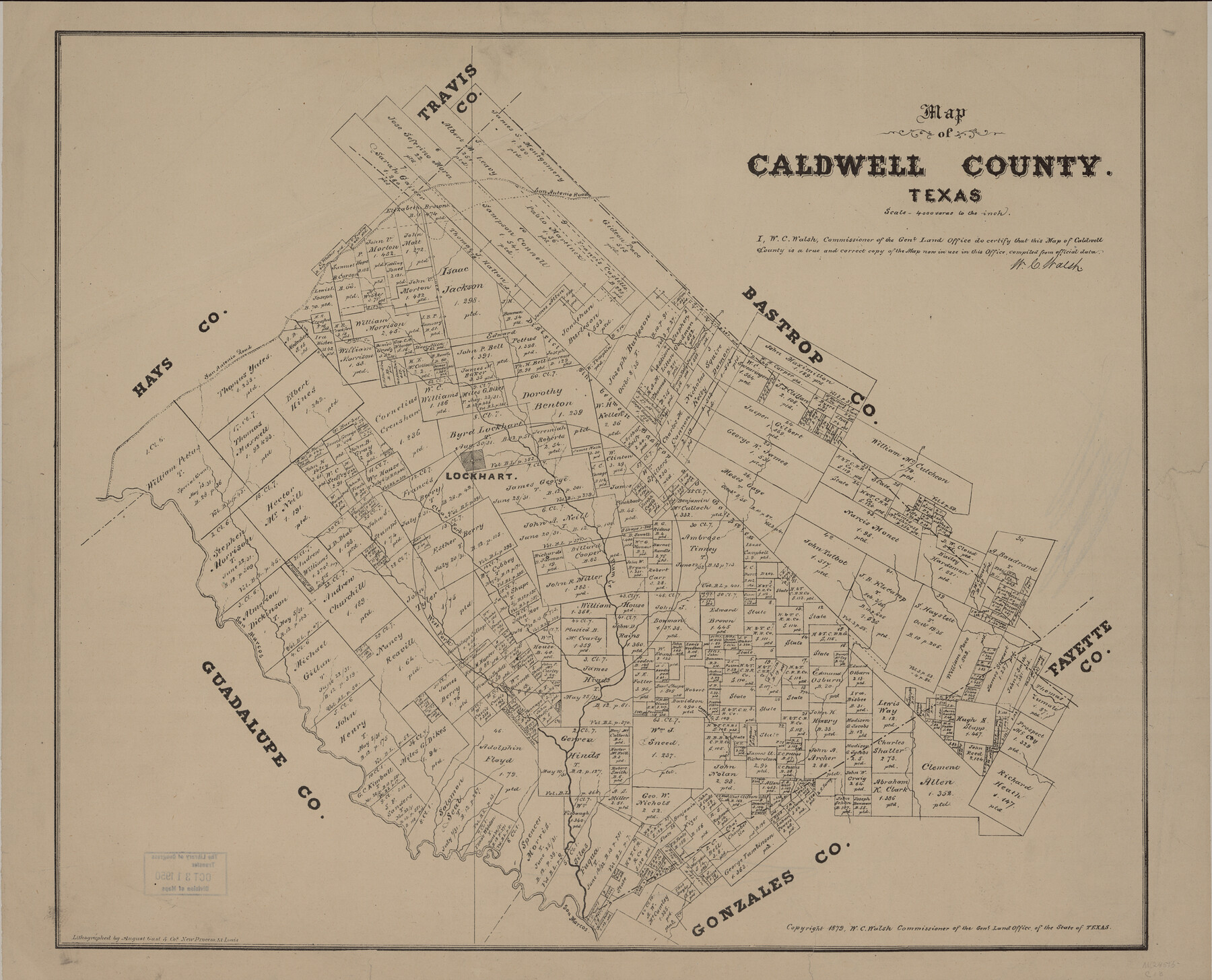
Map of Caldwell County, Texas
-
Map/Doc
88914
-
Collection
Library of Congress
-
Object Dates
1879 (Creation Date)
-
People and Organizations
General Land Office (Publisher)
W.C. Walsh (GLO Commissioner)
August Gast & Co. (Lithographer)
-
Counties
Caldwell
-
Subjects
County
-
Height x Width
17.4 x 21.5 inches
44.2 x 54.6 cm
-
Comments
Prints available from the GLO courtesy of Library of Congress, Geography and Map Division.
Part of: Library of Congress


Map of Texas, showing the line of the Texas and New Orleans Rail Road, and its connections in the U.S. and adjacent territories.

Print $20.00
Map of Texas, showing the line of the Texas and New Orleans Rail Road, and its connections in the U.S. and adjacent territories.
1860
Size 22.0 x 31.1 inches
Map/Doc 93612

Plano del Lago de Sn. Bernardo en el Seno Mexicano

Print $20.00
Plano del Lago de Sn. Bernardo en el Seno Mexicano
1792
Size 13.8 x 17.7 inches
Map/Doc 93617
Carte de la côte de la Louisiane depuis la Baye St. Joseph, jusqu'à celle de St. Bernard où tous les ports et bons mouillages sont marquez par des ancres; avec la quantité de piés d'eau que l'on y trouve.

Print $20.00
Carte de la côte de la Louisiane depuis la Baye St. Joseph, jusqu'à celle de St. Bernard où tous les ports et bons mouillages sont marquez par des ancres; avec la quantité de piés d'eau que l'on y trouve.
1732
Size 11.4 x 32.7 inches
Map/Doc 93607

Denison, Texas, Grayson County 1886

Print $20.00
Denison, Texas, Grayson County 1886
1886
Size 21.1 x 30.5 inches
Map/Doc 93466


Map showing the Atchison, Topeka and Santa Fe Railroad system, with its connections.

Print $20.00
Map showing the Atchison, Topeka and Santa Fe Railroad system, with its connections.
1883
Size 22.0 x 29.1 inches
Map/Doc 93583
You may also like
Hidalgo County Sketch

Print $20.00
- Digital $50.00
Hidalgo County Sketch
1903
Size 30.4 x 37.7 inches
Map/Doc 4450
Uvalde County Sketch File 25

Print $8.00
- Digital $50.00
Uvalde County Sketch File 25
1928
Size 14.5 x 8.8 inches
Map/Doc 39016
Map of Navarro County, Texas

Print $20.00
- Digital $50.00
Map of Navarro County, Texas
1871
Size 23.5 x 28.7 inches
Map/Doc 662
A Map of Louisiana and Mexico

Print $20.00
A Map of Louisiana and Mexico
1820
Size 43.0 x 32.6 inches
Map/Doc 76218
Map Showing Location of Galveston, Harrisburg & San Antonio Railway

Print $40.00
- Digital $50.00
Map Showing Location of Galveston, Harrisburg & San Antonio Railway
1881
Size 17.4 x 59.3 inches
Map/Doc 64457
General Highway Map. Detail of Cities and Towns in Bexar County, Texas. City Map of San Antonio, Alamo Heights, Olmos Park, Terrell Hills, Castle Hills, Balcones Heights, and vicinity, Bexar County, Texas

Print $20.00
General Highway Map. Detail of Cities and Towns in Bexar County, Texas. City Map of San Antonio, Alamo Heights, Olmos Park, Terrell Hills, Castle Hills, Balcones Heights, and vicinity, Bexar County, Texas
1961
Size 25.0 x 18.1 inches
Map/Doc 79374
[Map Showing Panhandle Counties in Texas]
![2087, [Map Showing Panhandle Counties in Texas], General Map Collection](https://historictexasmaps.com/wmedia_w700/maps/2087.tif.jpg)
Print $20.00
- Digital $50.00
[Map Showing Panhandle Counties in Texas]
1876
Size 27.3 x 27.9 inches
Map/Doc 2087
Johnson County Working Sketch 27

Print $20.00
- Digital $50.00
Johnson County Working Sketch 27
2006
Size 37.3 x 44.0 inches
Map/Doc 83651
General Highway Map, Marion County, Texas

Print $20.00
General Highway Map, Marion County, Texas
1961
Size 18.2 x 24.6 inches
Map/Doc 79582

Flight Mission No. DQN-2K, Frame 24, Calhoun County

Print $20.00
- Digital $50.00
Flight Mission No. DQN-2K, Frame 24, Calhoun County
1953
Size 18.6 x 22.2 inches
Map/Doc 84231
United States - Gulf Coast Texas - Southern part of Laguna Madre

Print $20.00
- Digital $50.00
United States - Gulf Coast Texas - Southern part of Laguna Madre
1933
Size 26.8 x 18.3 inches
Map/Doc 72949