Aransas County Rolled Sketch 33
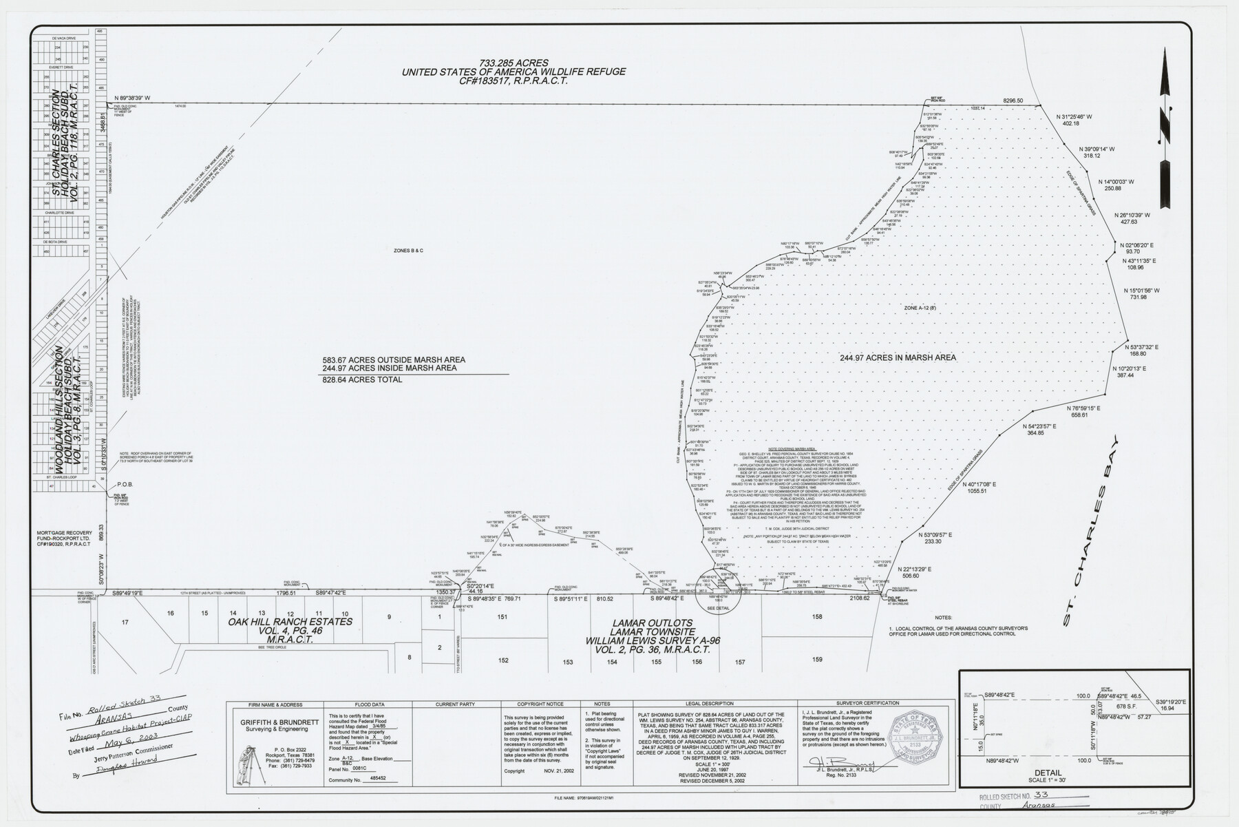
Plat showing survey of 828.64 acres of land out of the Wm. Lewis survey no. 254, abstract 96, Aransas County, Texas, and being that same tract called 833.317 acres in a deed from Ashby Minor James to Guy I. Warren, April 6, 1959
-
Map/Doc
78495
-
Collection
General Map Collection
-
Object Dates
2002/12/5 (Revision Date)
2003/5/6 (File Date)
2002/11/21 (Revision Date)
1997/6/20 (Creation Date)
2002/11/21 (Copyright Date)
-
People and Organizations
J.L. Brundrett (Surveyor/Engineer)
-
Counties
Aransas
-
Subjects
Surveying Rolled Sketch
-
Height x Width
24.5 x 36.8 inches
62.2 x 93.5 cm
-
Medium
mylar, print
-
Scale
1" = 300'
-
Comments
Whooping Crane Habitat Project - CIAP
Part of: General Map Collection
Kenedy County Aerial Photograph Index Sheet 2

Print $20.00
- Digital $50.00
Kenedy County Aerial Photograph Index Sheet 2
1943
Size 23.1 x 19.3 inches
Map/Doc 83714
Flight Mission No. BRE-1P, Frame 95, Nueces County

Print $20.00
- Digital $50.00
Flight Mission No. BRE-1P, Frame 95, Nueces County
1956
Size 18.4 x 22.2 inches
Map/Doc 86666
Jalisco Banco Number 67, cut from Mexico in 1909

Print $3.00
- Digital $50.00
Jalisco Banco Number 67, cut from Mexico in 1909
1912
Size 14.2 x 11.2 inches
Map/Doc 2064
Winkler County Rolled Sketch 5

Print $40.00
- Digital $50.00
Winkler County Rolled Sketch 5
1927
Size 58.0 x 38.4 inches
Map/Doc 10148
Crockett County Working Sketch 81

Print $20.00
- Digital $50.00
Crockett County Working Sketch 81
1973
Size 28.1 x 37.7 inches
Map/Doc 68414
Gregg County Rolled Sketch TMB

Print $20.00
- Digital $50.00
Gregg County Rolled Sketch TMB
1931
Size 20.9 x 20.8 inches
Map/Doc 6042
Culberson County Rolled Sketch 46

Print $40.00
- Digital $50.00
Culberson County Rolled Sketch 46
1953
Size 53.1 x 43.1 inches
Map/Doc 8754
Maps & Lists Showing Prison Lands (Oil & Gas) Leased as of June 1955

Digital $50.00
Maps & Lists Showing Prison Lands (Oil & Gas) Leased as of June 1955
1934
Size 29.6 x 38.1 inches
Map/Doc 62880
Travis County Boundary File 6a

Print $14.00
- Digital $50.00
Travis County Boundary File 6a
Size 11.5 x 9.0 inches
Map/Doc 59447
Runnels County Sketch File 6a

Print $4.00
Runnels County Sketch File 6a
1883
Size 12.9 x 8.2 inches
Map/Doc 35442
Wharton County

Print $40.00
- Digital $50.00
Wharton County
1894
Size 55.8 x 36.0 inches
Map/Doc 87352
Survey of all that part of lots 6, 7, and the north 1/2 of 20 foot alley lying south of said lots 6 and 7, all of lots 8, 9, 10, the east one half of lot 11, all of lot 13, lying south and adjacent to the southerly seawall right-of-way line

Print $2.00
- Digital $50.00
Survey of all that part of lots 6, 7, and the north 1/2 of 20 foot alley lying south of said lots 6 and 7, all of lots 8, 9, 10, the east one half of lot 11, all of lot 13, lying south and adjacent to the southerly seawall right-of-way line
1969
Size 17.0 x 15.3 inches
Map/Doc 73624
You may also like
Bandera County Working Sketch 27

Print $20.00
- Digital $50.00
Bandera County Working Sketch 27
1950
Size 15.0 x 17.1 inches
Map/Doc 67623
Mineral Plats - Brewster, Culberson and Duval

Mineral Plats - Brewster, Culberson and Duval
Map/Doc 81745
Map of the country adjacent to the left bank of the Rio Grande below Matamoros

Print $20.00
- Digital $50.00
Map of the country adjacent to the left bank of the Rio Grande below Matamoros
1847
Size 18.3 x 27.5 inches
Map/Doc 72870
Kinney County Working Sketch 45

Print $20.00
- Digital $50.00
Kinney County Working Sketch 45
1978
Size 28.6 x 26.5 inches
Map/Doc 70227
Anderson County Working Sketch 10

Print $20.00
- Digital $50.00
Anderson County Working Sketch 10
1933
Size 31.0 x 48.5 inches
Map/Doc 67009
Bennett and Norman, 30 Acres

Print $20.00
- Digital $50.00
Bennett and Norman, 30 Acres
Size 27.9 x 9.7 inches
Map/Doc 92721
Starr County Rolled Sketch 33

Print $20.00
- Digital $50.00
Starr County Rolled Sketch 33
1944
Size 21.9 x 30.8 inches
Map/Doc 7830
Van Zandt County Sketch File 29

Print $4.00
- Digital $50.00
Van Zandt County Sketch File 29
1859
Size 8.3 x 6.2 inches
Map/Doc 39453
Midland County Working Sketch 19a

Print $20.00
- Digital $50.00
Midland County Working Sketch 19a
Size 20.2 x 23.4 inches
Map/Doc 71000
Hudspeth County Working Sketch 29

Print $40.00
- Digital $50.00
Hudspeth County Working Sketch 29
1972
Size 31.5 x 55.2 inches
Map/Doc 66311
Concho County Rolled Sketch 8

Print $20.00
- Digital $50.00
Concho County Rolled Sketch 8
1956
Size 24.0 x 15.9 inches
Map/Doc 5546
[Gulf Colorado & Santa Fe from 2178+36.0 to 3901+06.2]
![64697, [Gulf Colorado & Santa Fe from 2178+36.0 to 3901+06.2], General Map Collection](https://historictexasmaps.com/wmedia_w700/maps/64697-1.tif.jpg)
Print $40.00
- Digital $50.00
[Gulf Colorado & Santa Fe from 2178+36.0 to 3901+06.2]
Size 33.2 x 121.6 inches
Map/Doc 64697