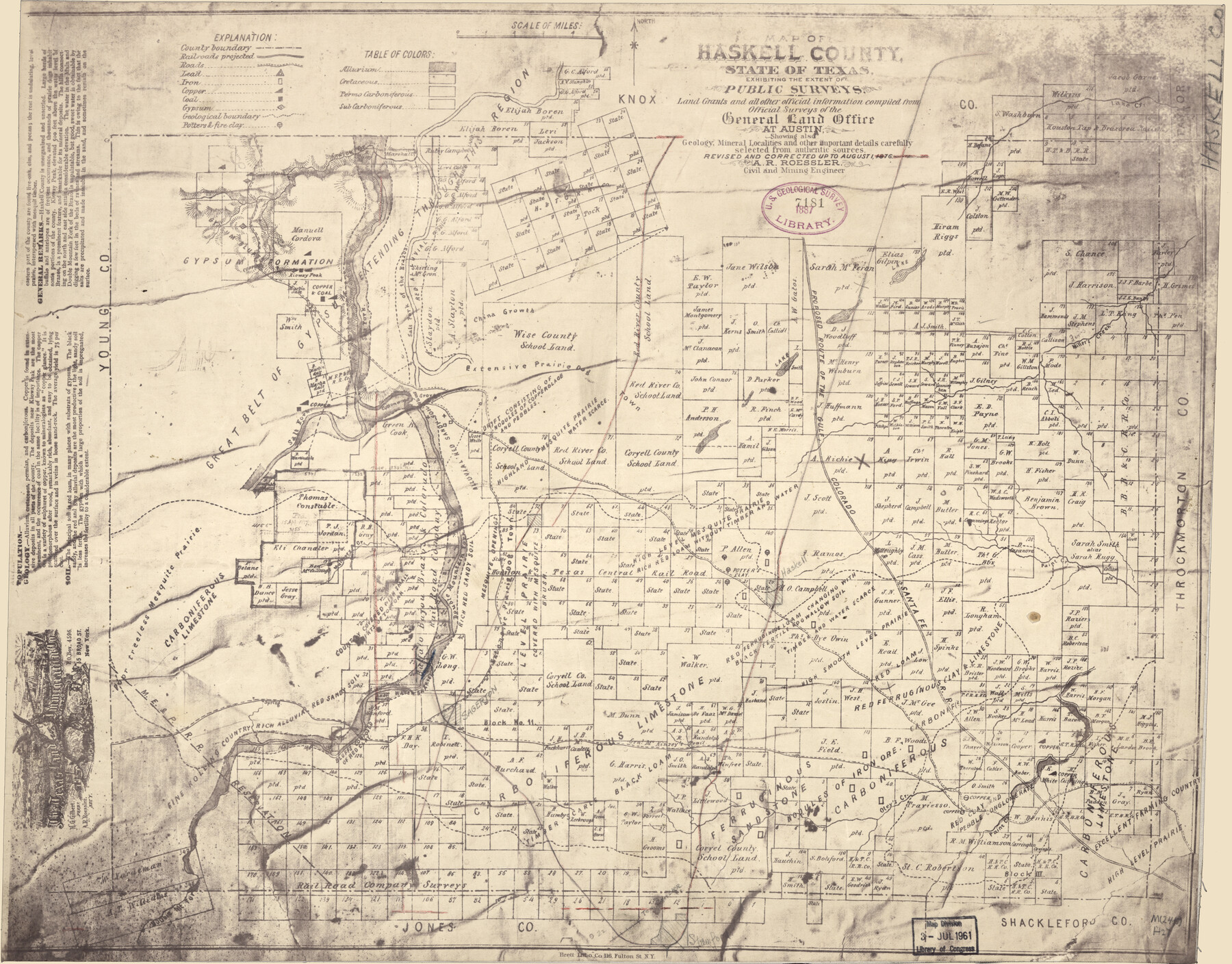
Map of Haskell County
-
Map/Doc
88950
-
Collection
Library of Congress
-
Object Dates
1876 (Creation Date)
-
People and Organizations
Texas Land and Immigration Company (Publisher)
Brett Lithographic Company (Printer)
A.R. Roessler (Compiler)
-
Counties
Haskell
-
Subjects
County
-
Height x Width
18.2 x 23.1 inches
46.2 x 58.7 cm
-
Comments
Prints available from the GLO courtesy of Library of Congress, Geography and Map Division.
Part of: Library of Congress
Map of Jack County, State of Texas : exhibiting the extent of public surveys land grants and all other official information compiled from official surveys of the Genral Land Office at Austin…

Print $20.00
Map of Jack County, State of Texas : exhibiting the extent of public surveys land grants and all other official information compiled from official surveys of the Genral Land Office at Austin…
1876
Size 16.5 x 15.4 inches
Map/Doc 93591

J. H. Colton's map of the state of Louisiana and eastern part of Texas compiled from United States Surveys, and other authentic sources, showing the counties, townships, sections. Fractional sections, settlement rights, railroads, &c.

Print $20.00
J. H. Colton's map of the state of Louisiana and eastern part of Texas compiled from United States Surveys, and other authentic sources, showing the counties, townships, sections. Fractional sections, settlement rights, railroads, &c.
1863
Size 35.8 x 43.3 inches
Map/Doc 93603
Sunset, Montague Co., Texas

Print $20.00
Sunset, Montague Co., Texas
1890
Size 21.0 x 37.0 inches
Map/Doc 93481

Perspective Map of Texarkana, Texas and Arkansas

Print $20.00
Perspective Map of Texarkana, Texas and Arkansas
1888
Size 18.1 x 29.2 inches
Map/Doc 93485
The Santa Fe Route and connections

Print $20.00
The Santa Fe Route and connections
1888
Size 15.4 x 24.8 inches
Map/Doc 96972
Map of Caldwell County, Texas

Print $20.00
Map of Caldwell County, Texas
1879
Size 17.4 x 21.5 inches
Map/Doc 88914
![88956, Hood Co[unty], Library of Congress](https://historictexasmaps.com/wmedia_w700/maps/88956.tif.jpg)
Map of Kaufman and Rockwall Counties, Texas

Print $20.00
Map of Kaufman and Rockwall Counties, Texas
1878
Size 23.4 x 17.3 inches
Map/Doc 88963
Corpus Christi and Rio Grande Railway Company, [map showing the proposed railroad between Laredo and Corpus Christi and its connections with Mexico]
![93580, Corpus Christi and Rio Grande Railway Company, [map showing the proposed railroad between Laredo and Corpus Christi and its connections with Mexico], Library of Congress](https://historictexasmaps.com/wmedia_w700/maps/93580.tif.jpg)
Print $20.00
Corpus Christi and Rio Grande Railway Company, [map showing the proposed railroad between Laredo and Corpus Christi and its connections with Mexico]
1874
Size 14.6 x 24.0 inches
Map/Doc 93580
The railroad system of Texas on September 1st, 1883

Print $20.00
The railroad system of Texas on September 1st, 1883
1883
Size 20.1 x 26.8 inches
Map/Doc 93618
You may also like
[Sketch for Mineral Application 12206 - Cow Bayou, O. B. Sawyer]
![65569, [Sketch for Mineral Application 12206 - Cow Bayou, O. B. Sawyer], General Map Collection](https://historictexasmaps.com/wmedia_w700/maps/65569.tif.jpg)
Print $40.00
- Digital $50.00
[Sketch for Mineral Application 12206 - Cow Bayou, O. B. Sawyer]
Size 63.3 x 36.5 inches
Map/Doc 65569
Jefferson County Rolled Sketch 9

Print $20.00
- Digital $50.00
Jefferson County Rolled Sketch 9
Size 36.6 x 47.0 inches
Map/Doc 9276
Crockett County Working Sketch 50

Print $20.00
- Digital $50.00
Crockett County Working Sketch 50
1940
Size 30.3 x 24.9 inches
Map/Doc 68383
Potter County Boundary File 6b

Print $20.00
- Digital $50.00
Potter County Boundary File 6b
Size 37.9 x 8.7 inches
Map/Doc 58040
Kimble County Working Sketch 21

Print $20.00
- Digital $50.00
Kimble County Working Sketch 21
1929
Size 24.1 x 15.3 inches
Map/Doc 70089
Shelby County Working Sketch 23b

Print $20.00
- Digital $50.00
Shelby County Working Sketch 23b
1983
Size 36.6 x 24.7 inches
Map/Doc 63877
Rockwall County

Print $20.00
- Digital $50.00
Rockwall County
1941
Size 28.5 x 23.9 inches
Map/Doc 63006
Flight Mission No. CRC-1R, Frame 155, Chambers County

Print $20.00
- Digital $50.00
Flight Mission No. CRC-1R, Frame 155, Chambers County
1956
Size 18.8 x 22.4 inches
Map/Doc 84717
Haskell County

Print $20.00
- Digital $50.00
Haskell County
1873
Size 20.1 x 24.2 inches
Map/Doc 3642
Flight Mission No. CRK-7P, Frame 79, Refugio County

Print $20.00
- Digital $50.00
Flight Mission No. CRK-7P, Frame 79, Refugio County
1956
Size 18.2 x 22.1 inches
Map/Doc 86950
The Pringle and Grieve Colony. November 1, 1843

Print $20.00
The Pringle and Grieve Colony. November 1, 1843
2020
Size 23.0 x 17.7 inches
Map/Doc 96371
Galveston County Sketch File 1b

Print $6.00
- Digital $50.00
Galveston County Sketch File 1b
1845
Size 16.2 x 11.0 inches
Map/Doc 23347