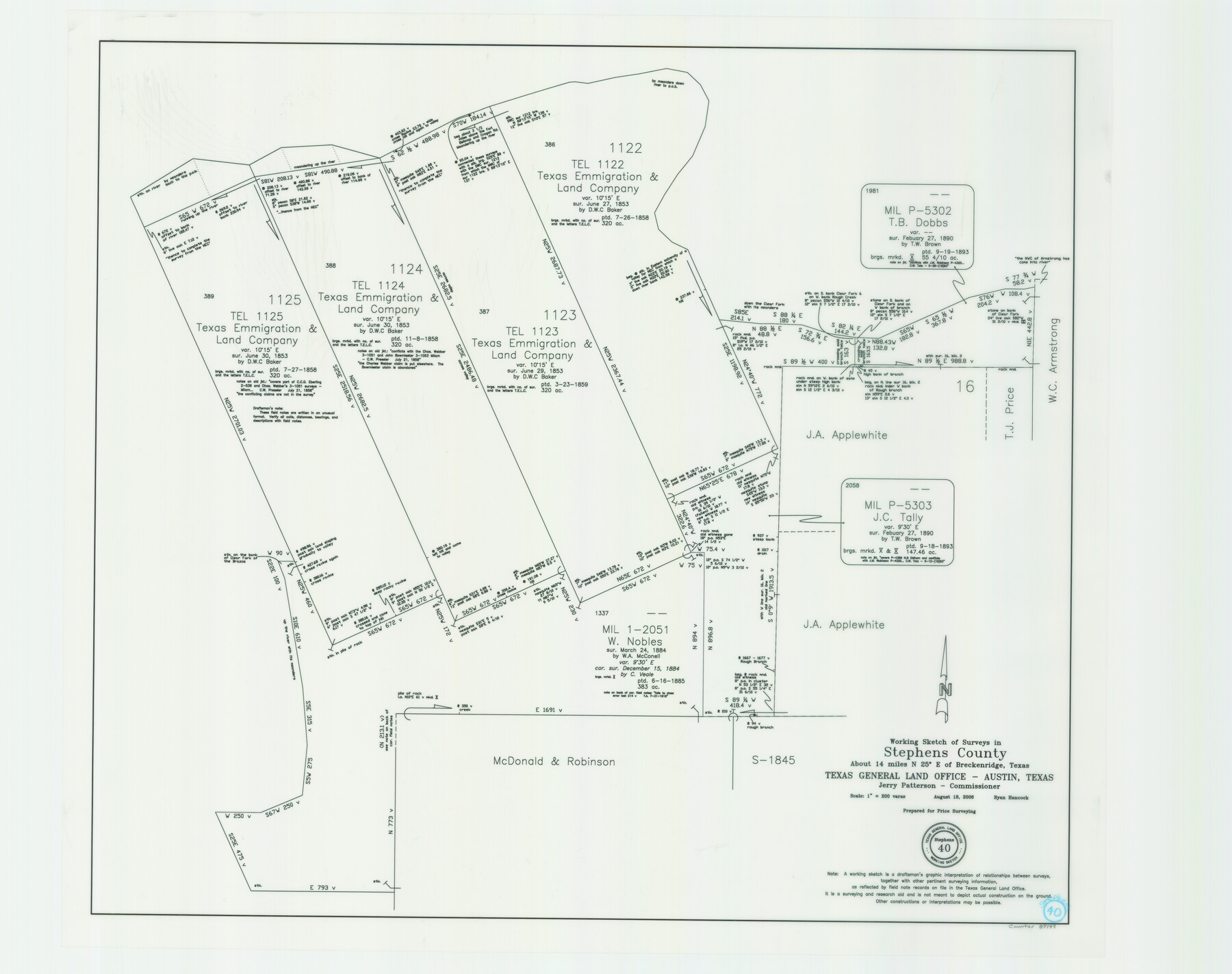
Stephens County Working Sketch 40
-
Map/Doc
87149
-
Collection
General Map Collection
-
Object Dates
8/18/2006 (Creation Date)
-
People and Organizations
Jerry E. Patterson (GLO Commissioner)
Ryan Hancock (Draftsman)
-
Counties
Stephens
-
Subjects
Surveying Working Sketch
-
Height x Width
26.9 x 34.0 inches
68.3 x 86.4 cm
-
Scale
1" = 200 varas
-
Comments
Located about 14 miles North 25 degrees East of Breckenridge, Texas.
Part of: General Map Collection
Edwards County Boundary File 27d

Print $10.00
- Digital $50.00
Edwards County Boundary File 27d
Size 12.8 x 8.5 inches
Map/Doc 52901
Webb County Working Sketch 18

Print $20.00
- Digital $50.00
Webb County Working Sketch 18
1923
Size 18.6 x 12.8 inches
Map/Doc 72383
Archer County Sketch File 5

Print $4.00
- Digital $50.00
Archer County Sketch File 5
1858
Size 7.8 x 8.7 inches
Map/Doc 13632
Flight Mission No. DQN-5K, Frame 143, Calhoun County

Print $20.00
- Digital $50.00
Flight Mission No. DQN-5K, Frame 143, Calhoun County
1953
Size 18.8 x 22.3 inches
Map/Doc 84418
Fort Bend County Working Sketch Graphic Index

Print $20.00
- Digital $50.00
Fort Bend County Working Sketch Graphic Index
1931
Size 40.7 x 41.9 inches
Map/Doc 76545
Brazoria County NRC Article 33.136 Sketch 13

Print $42.00
- Digital $50.00
Brazoria County NRC Article 33.136 Sketch 13
2012
Size 36.0 x 23.0 inches
Map/Doc 95069
McLennan County Boundary File 1a

Print $14.00
- Digital $50.00
McLennan County Boundary File 1a
Size 8.0 x 6.6 inches
Map/Doc 56941
Val Verde County Sketch File XXX7

Print $6.00
- Digital $50.00
Val Verde County Sketch File XXX7
Size 11.0 x 15.4 inches
Map/Doc 39104
Carta Historica y Arqueologica

Print $20.00
- Digital $50.00
Carta Historica y Arqueologica
Size 26.0 x 34.4 inches
Map/Doc 96806
Runnels County Rolled Sketch 47

Print $40.00
- Digital $50.00
Runnels County Rolled Sketch 47
1954
Size 49.9 x 30.5 inches
Map/Doc 76167
Kimble County Working Sketch 6

Print $20.00
- Digital $50.00
Kimble County Working Sketch 6
1915
Size 24.4 x 26.5 inches
Map/Doc 70074
Bosque County Sketch File 2

Print $4.00
- Digital $50.00
Bosque County Sketch File 2
1847
Size 7.8 x 12.4 inches
Map/Doc 14740
You may also like
Eastland County Sketch File 10

Print $42.00
- Digital $50.00
Eastland County Sketch File 10
Size 7.0 x 7.8 inches
Map/Doc 21582
Haskell County Sketch File 1A

Print $40.00
- Digital $50.00
Haskell County Sketch File 1A
Size 12.3 x 14.5 inches
Map/Doc 26119
Van Zandt County Rolled Sketch 9

Print $20.00
- Digital $50.00
Van Zandt County Rolled Sketch 9
1963
Size 23.4 x 18.7 inches
Map/Doc 8149
Tyler County Working Sketch 26

Print $20.00
- Digital $50.00
Tyler County Working Sketch 26
Size 27.7 x 46.3 inches
Map/Doc 69496
Flight Mission No. BRE-2P, Frame 50, Nueces County

Print $20.00
- Digital $50.00
Flight Mission No. BRE-2P, Frame 50, Nueces County
1956
Size 18.5 x 22.4 inches
Map/Doc 86752
Loving County Working Sketch 16a

Print $20.00
- Digital $50.00
Loving County Working Sketch 16a
1976
Size 45.4 x 29.3 inches
Map/Doc 70650
Menard County Sketch File 29

Print $20.00
- Digital $50.00
Menard County Sketch File 29
1962
Size 21.0 x 41.1 inches
Map/Doc 10543
Limestone County Sketch File 11

Print $4.00
- Digital $50.00
Limestone County Sketch File 11
1881
Size 7.9 x 9.5 inches
Map/Doc 30177
General Highway Map, Washington County, Texas

Print $20.00
General Highway Map, Washington County, Texas
1940
Size 18.4 x 25.0 inches
Map/Doc 79272
Flight Mission No. DCL-6C, Frame 2, Kenedy County

Print $20.00
- Digital $50.00
Flight Mission No. DCL-6C, Frame 2, Kenedy County
1943
Size 18.6 x 22.4 inches
Map/Doc 85862
Kerr County Sketch File 1b

Print $2.00
- Digital $50.00
Kerr County Sketch File 1b
Size 8.1 x 10.2 inches
Map/Doc 28850
Kerr County Working Sketch 3

Print $20.00
- Digital $50.00
Kerr County Working Sketch 3
1944
Size 15.7 x 21.0 inches
Map/Doc 70034