Edwards County Boundary File 27d
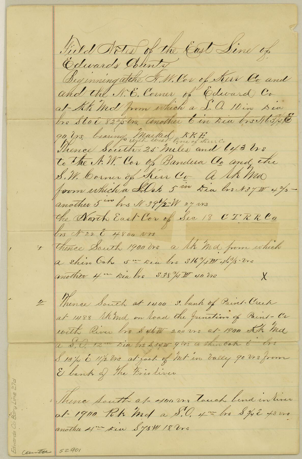
Field Notes of the East Line of Edwards County
-
Map/Doc
52901
-
Collection
General Map Collection
-
Counties
Edwards
-
Subjects
County Boundaries
-
Height x Width
12.8 x 8.5 inches
32.5 x 21.6 cm
Part of: General Map Collection
[Sketch for Mineral Application 26501 - Sabine River, T. A. Oldhausen]
![2846, [Sketch for Mineral Application 26501 - Sabine River, T. A. Oldhausen], General Map Collection](https://historictexasmaps.com/wmedia_w700/maps/2846.tif.jpg)
Print $20.00
- Digital $50.00
[Sketch for Mineral Application 26501 - Sabine River, T. A. Oldhausen]
1931
Size 24.4 x 37.0 inches
Map/Doc 2846
Matagorda County Rolled Sketch 24

Print $40.00
- Digital $50.00
Matagorda County Rolled Sketch 24
1945
Size 53.2 x 29.6 inches
Map/Doc 9478
Dimmit County Rolled Sketch 11

Print $20.00
- Digital $50.00
Dimmit County Rolled Sketch 11
1942
Size 21.8 x 28.9 inches
Map/Doc 5720
Wichita County Working Sketch 22

Print $20.00
- Digital $50.00
Wichita County Working Sketch 22
1952
Size 22.2 x 27.1 inches
Map/Doc 72532
Map of Rusk County

Print $20.00
- Digital $50.00
Map of Rusk County
1846
Size 31.6 x 20.6 inches
Map/Doc 4006
[Beaumont, Sour Lake and Western Ry. Right of Way and Alignment - Frisco]
![64115, [Beaumont, Sour Lake and Western Ry. Right of Way and Alignment - Frisco], General Map Collection](https://historictexasmaps.com/wmedia_w700/maps/64115.tif.jpg)
Print $20.00
- Digital $50.00
[Beaumont, Sour Lake and Western Ry. Right of Way and Alignment - Frisco]
1910
Size 20.1 x 45.9 inches
Map/Doc 64115
[Kansas City, Mexico & Orient]
![64268, [Kansas City, Mexico & Orient], General Map Collection](https://historictexasmaps.com/wmedia_w700/maps/64268-1.tif.jpg)
Print $40.00
- Digital $50.00
[Kansas City, Mexico & Orient]
1904
Size 16.2 x 123.7 inches
Map/Doc 64268
Lake Corpus Christi and a city map of Mathis, Texas [Recto]
![94170, Lake Corpus Christi and a city map of Mathis, Texas [Recto], General Map Collection](https://historictexasmaps.com/wmedia_w700/maps/94170.tif.jpg)
Lake Corpus Christi and a city map of Mathis, Texas [Recto]
1984
Size 29.2 x 22.8 inches
Map/Doc 94170
Amistad International Reservoir on Rio Grande 77

Print $20.00
- Digital $50.00
Amistad International Reservoir on Rio Grande 77
1949
Size 28.5 x 40.2 inches
Map/Doc 75505
Travis County

Print $40.00
- Digital $50.00
Travis County
1963
Size 37.7 x 50.7 inches
Map/Doc 73597
Coryell County Sketch File 11

Print $4.00
- Digital $50.00
Coryell County Sketch File 11
Size 8.7 x 11.7 inches
Map/Doc 19364
Marion County Sketch File 3

Print $8.00
- Digital $50.00
Marion County Sketch File 3
1860
Size 14.1 x 8.8 inches
Map/Doc 30566
You may also like
PSL Field Notes for Block A19 in Andrews County, C45 in Andrews and Gaines Counties, C31 in Dawson and Gaines Counties, C34 in Terry and Gaines Counties, C35 in Yoakum and Gaines Counties, and Blocks C30, C32, C33, C43, and C44 in Gaines County

PSL Field Notes for Block A19 in Andrews County, C45 in Andrews and Gaines Counties, C31 in Dawson and Gaines Counties, C34 in Terry and Gaines Counties, C35 in Yoakum and Gaines Counties, and Blocks C30, C32, C33, C43, and C44 in Gaines County
Map/Doc 81643
Duval County Rolled Sketch 19

Print $4.00
- Digital $50.00
Duval County Rolled Sketch 19
1940
Size 20.2 x 15.1 inches
Map/Doc 5740
Runnels County Sketch File 32

Print $4.00
Runnels County Sketch File 32
1950
Size 23.6 x 22.6 inches
Map/Doc 12263
Sherman County Rolled Sketch 14

Print $20.00
- Digital $50.00
Sherman County Rolled Sketch 14
1975
Size 17.4 x 17.7 inches
Map/Doc 7795
Galveston County NRC Article 33.136 Sketch 98

Print $32.00
Galveston County NRC Article 33.136 Sketch 98
2024
Map/Doc 97409
Mexico, Regia et Celebris Hispaniae Novae Civitas [and] Cusco, Rengi Peru in Novo Orbe Casvt
![97025, Mexico, Regia et Celebris Hispaniae Novae Civitas [and] Cusco, Rengi Peru in Novo Orbe Casvt, General Map Collection](https://historictexasmaps.com/wmedia_w700/maps/97025-1.tif.jpg)
Print $20.00
- Digital $50.00
Mexico, Regia et Celebris Hispaniae Novae Civitas [and] Cusco, Rengi Peru in Novo Orbe Casvt
1572
Size 13.8 x 20.1 inches
Map/Doc 97025
Morris County Rolled Sketch 2

Print $40.00
- Digital $50.00
Morris County Rolled Sketch 2
1944
Size 59.4 x 43.5 inches
Map/Doc 9550
Ochiltree County Working Sketch 5

Print $40.00
- Digital $50.00
Ochiltree County Working Sketch 5
1961
Size 110.0 x 37.3 inches
Map/Doc 71318
Henderson County Rolled Sketch 11

Print $20.00
- Digital $50.00
Henderson County Rolled Sketch 11
1915
Size 29.4 x 42.6 inches
Map/Doc 75955
Galveston Bay and Approaches

Print $40.00
- Digital $50.00
Galveston Bay and Approaches
1982
Size 51.4 x 37.0 inches
Map/Doc 69885
Ward County Rolled Sketch 16

Print $20.00
- Digital $50.00
Ward County Rolled Sketch 16
1942
Size 30.5 x 21.7 inches
Map/Doc 8159
Township 2 South Range 12 West, South Western District, Louisiana

Print $20.00
- Digital $50.00
Township 2 South Range 12 West, South Western District, Louisiana
1884
Size 19.7 x 24.7 inches
Map/Doc 65882