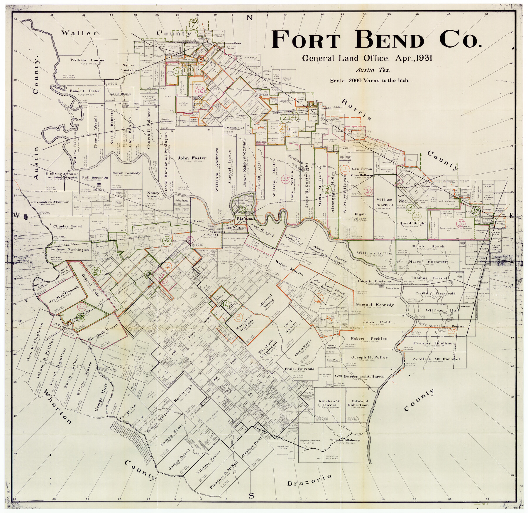
Fort Bend County Working Sketch Graphic Index
-
Map/Doc
76545
-
Collection
General Map Collection
-
Object Dates
4/1931 (Creation Date)
-
Counties
Fort Bend
-
Subjects
County Surveying Working Sketch
-
Height x Width
40.7 x 41.9 inches
103.4 x 106.4 cm
-
Scale
1" = 2000 varas
Part of: General Map Collection
Kaufman County Sketch File 5

Print $22.00
- Digital $50.00
Kaufman County Sketch File 5
1849
Size 7.6 x 12.6 inches
Map/Doc 28632
Current Miscellaneous File 117

Print $8.00
- Digital $50.00
Current Miscellaneous File 117
2001
Size 11.2 x 8.8 inches
Map/Doc 74823
Shelby County Rolled Sketch 5

Print $20.00
- Digital $50.00
Shelby County Rolled Sketch 5
1942
Size 37.9 x 43.7 inches
Map/Doc 9921
Glasscock County Rolled Sketch 16

Print $40.00
- Digital $50.00
Glasscock County Rolled Sketch 16
1986
Size 63.3 x 46.1 inches
Map/Doc 9060
Flight Mission No. DQO-11K, Frame 24, Galveston County

Print $20.00
- Digital $50.00
Flight Mission No. DQO-11K, Frame 24, Galveston County
1952
Size 18.6 x 22.4 inches
Map/Doc 85221
Map of Shelby County

Print $20.00
- Digital $50.00
Map of Shelby County
1863
Size 18.6 x 22.3 inches
Map/Doc 4031
Borden County Sketch File 3a

Print $4.00
- Digital $50.00
Borden County Sketch File 3a
1902
Size 12.5 x 8.6 inches
Map/Doc 14705
Wilson County Boundary File 9

Print $42.00
- Digital $50.00
Wilson County Boundary File 9
Size 14.3 x 8.9 inches
Map/Doc 60119
Runnels County Rolled Sketch 33

Print $20.00
- Digital $50.00
Runnels County Rolled Sketch 33
Size 22.5 x 43.5 inches
Map/Doc 7520
Fort Bend County Working Sketch 18

Print $20.00
- Digital $50.00
Fort Bend County Working Sketch 18
1957
Size 34.7 x 38.2 inches
Map/Doc 69224
Hardeman County Sketch File Y

Print $4.00
- Digital $50.00
Hardeman County Sketch File Y
Size 9.2 x 8.5 inches
Map/Doc 25054
Amistad International Reservoir on Rio Grande 94

Print $20.00
- Digital $50.00
Amistad International Reservoir on Rio Grande 94
1950
Size 28.6 x 41.0 inches
Map/Doc 75524
You may also like
Newton County Working Sketch 38

Print $20.00
- Digital $50.00
Newton County Working Sketch 38
1961
Size 36.8 x 29.2 inches
Map/Doc 71284
Working Sketch in Wichita County [in northern part of county]
![91992, Working Sketch in Wichita County [in northern part of county], Twichell Survey Records](https://historictexasmaps.com/wmedia_w700/maps/91992-1.tif.jpg)
Print $20.00
- Digital $50.00
Working Sketch in Wichita County [in northern part of county]
1919
Size 38.3 x 18.5 inches
Map/Doc 91992
Hood County Rolled Sketch 8

Print $20.00
- Digital $50.00
Hood County Rolled Sketch 8
2011
Size 19.3 x 24.5 inches
Map/Doc 90084
Hamilton County Working Sketch 4

Print $20.00
- Digital $50.00
Hamilton County Working Sketch 4
1935
Size 32.6 x 36.9 inches
Map/Doc 63342
[Map showing Block 35, Townships 1N-5N]
![93207, [Map showing Block 35, Townships 1N-5N], Twichell Survey Records](https://historictexasmaps.com/wmedia_w700/maps/93207-1.tif.jpg)
Print $40.00
- Digital $50.00
[Map showing Block 35, Townships 1N-5N]
Size 22.8 x 83.0 inches
Map/Doc 93207
Shelby County Working Sketch 6

Print $20.00
- Digital $50.00
Shelby County Working Sketch 6
1941
Size 25.1 x 18.9 inches
Map/Doc 63859
Throckmorton County

Print $20.00
- Digital $50.00
Throckmorton County
1943
Size 40.1 x 32.8 inches
Map/Doc 77435
Travis County Sketch File 37

Print $4.00
- Digital $50.00
Travis County Sketch File 37
Size 8.2 x 10.1 inches
Map/Doc 38357
Hunt County Working Sketch 4

Print $20.00
- Digital $50.00
Hunt County Working Sketch 4
1923
Size 21.3 x 30.5 inches
Map/Doc 66351
Flight Mission No. DIX-5P, Frame 106, Aransas County

Print $20.00
- Digital $50.00
Flight Mission No. DIX-5P, Frame 106, Aransas County
1956
Size 17.8 x 18.0 inches
Map/Doc 83784

Reeves County Working Sketch 30

Print $20.00
- Digital $50.00
Reeves County Working Sketch 30
1969
Size 31.1 x 36.5 inches
Map/Doc 63473