Menard County Sketch File 29
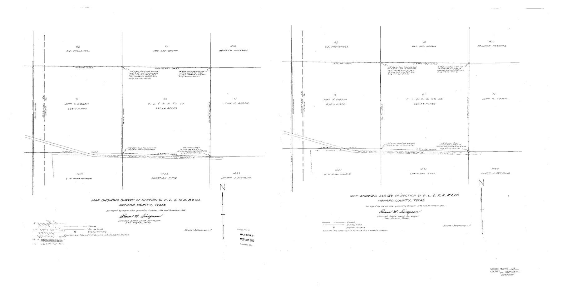
Map showing survey of Section 61 E.L.&R.R. Ry. Co. Menard County, Texas
-
Map/Doc
10543
-
Collection
General Map Collection
-
Object Dates
11/1962 (Creation Date)
11/30/1962 (File Date)
10/1946 (Survey Date)
11/1962 (Survey Date)
-
People and Organizations
Roscoe M. Simpson (Surveyor/Engineer)
-
Counties
Menard Schleicher
-
Subjects
Surveying Sketch File
-
Height x Width
21.0 x 41.1 inches
53.3 x 104.4 cm
-
Medium
paper, print
-
Scale
1:300
-
Features
[Road] to Eldorado
State Ranch Highway No. 79
[Road] to Menard
Part of: General Map Collection
Goliad County Sketch File 38

Print $4.00
- Digital $50.00
Goliad County Sketch File 38
1859
Size 13.0 x 8.1 inches
Map/Doc 24338
Live Oak County Working Sketch 21

Print $20.00
- Digital $50.00
Live Oak County Working Sketch 21
1964
Size 30.8 x 33.9 inches
Map/Doc 70606
Reeves County Working Sketch 41

Print $40.00
- Digital $50.00
Reeves County Working Sketch 41
1973
Size 42.5 x 53.4 inches
Map/Doc 63484
Webb County Sketch File 14

Print $7.00
- Digital $50.00
Webb County Sketch File 14
1877
Size 10.0 x 8.2 inches
Map/Doc 39807
[Right of Way & Track Map, The Texas & Pacific Ry. Co. Main Line]
![64688, [Right of Way & Track Map, The Texas & Pacific Ry. Co. Main Line], General Map Collection](https://historictexasmaps.com/wmedia_w700/maps/64688.tif.jpg)
Print $20.00
- Digital $50.00
[Right of Way & Track Map, The Texas & Pacific Ry. Co. Main Line]
Size 11.0 x 19.0 inches
Map/Doc 64688
Donley County Boundary File 4

Print $10.00
- Digital $50.00
Donley County Boundary File 4
Size 5.7 x 8.4 inches
Map/Doc 52630
Liberty County Sketch File 38

Print $22.00
- Digital $50.00
Liberty County Sketch File 38
1899
Size 13.9 x 8.9 inches
Map/Doc 29983
Cherokee County Working Sketch 8
Print $20.00
- Digital $50.00
Cherokee County Working Sketch 8
1956
Size 22.0 x 45.2 inches
Map/Doc 67963
Pecos County Rolled Sketch 36

Print $20.00
- Digital $50.00
Pecos County Rolled Sketch 36
1906
Size 32.0 x 23.4 inches
Map/Doc 7216
Johnson County Sketch File 15

Print $2.00
- Digital $50.00
Johnson County Sketch File 15
1881
Size 8.1 x 7.3 inches
Map/Doc 28455
Township No. 1 South Range No. 20 West of the Indian Meridian

Print $20.00
- Digital $50.00
Township No. 1 South Range No. 20 West of the Indian Meridian
1875
Size 19.3 x 24.4 inches
Map/Doc 75179
A Correct Map of the Seat of War in Mexico Being a Copy of Genl Arista's Map, taken at Resaca de la Palma, with additions and Corrections

Print $20.00
- Digital $50.00
A Correct Map of the Seat of War in Mexico Being a Copy of Genl Arista's Map, taken at Resaca de la Palma, with additions and Corrections
1847
Size 30.7 x 22.5 inches
Map/Doc 93962
You may also like
Garza County Rolled Sketch 11B

Print $20.00
- Digital $50.00
Garza County Rolled Sketch 11B
1915
Size 24.6 x 24.8 inches
Map/Doc 6001
Schleicher County Working Sketch 3

Print $20.00
- Digital $50.00
Schleicher County Working Sketch 3
1914
Size 23.2 x 17.6 inches
Map/Doc 63805
Parker County Sketch File 31

Print $6.00
- Digital $50.00
Parker County Sketch File 31
1877
Size 9.9 x 9.8 inches
Map/Doc 33572
Right of Way and Track Map, the Missouri, Kansas & Texas Ry. Of Texas operated by the Missouri, Kansas & Texas Ry. Of Texas, Houston Division

Print $40.00
- Digital $50.00
Right of Way and Track Map, the Missouri, Kansas & Texas Ry. Of Texas operated by the Missouri, Kansas & Texas Ry. Of Texas, Houston Division
1918
Size 25.5 x 61.9 inches
Map/Doc 64567
[Stone, Kyle and Kyle Block M6]
![90414, [Stone, Kyle and Kyle Block M6], Twichell Survey Records](https://historictexasmaps.com/wmedia_w700/maps/90414-1.tif.jpg)
Print $20.00
- Digital $50.00
[Stone, Kyle and Kyle Block M6]
1908
Size 18.6 x 25.5 inches
Map/Doc 90414
Red River County Working Sketch 44

Print $20.00
- Digital $50.00
Red River County Working Sketch 44
1968
Size 28.1 x 28.3 inches
Map/Doc 72027
Jasper County Sketch File 36

Print $32.00
- Digital $50.00
Jasper County Sketch File 36
1987
Size 11.2 x 8.6 inches
Map/Doc 27872
Gulf Coast of the United States, Key West to Rio Grande

Print $20.00
- Digital $50.00
Gulf Coast of the United States, Key West to Rio Grande
1892
Size 27.3 x 18.3 inches
Map/Doc 72671
Dallas County Rolled Sketch 5

Print $20.00
- Digital $50.00
Dallas County Rolled Sketch 5
1955
Size 23.8 x 30.8 inches
Map/Doc 5689
The Republic County of Brazoria. May 15, 1838

Print $20.00
The Republic County of Brazoria. May 15, 1838
2020
Size 14.7 x 21.8 inches
Map/Doc 96112
Hemphill County Rolled Sketch 15

Print $20.00
- Digital $50.00
Hemphill County Rolled Sketch 15
1961
Size 44.7 x 21.5 inches
Map/Doc 6194
Concho County Sketch File 47

Print $20.00
- Digital $50.00
Concho County Sketch File 47
1950
Size 16.8 x 21.0 inches
Map/Doc 11165