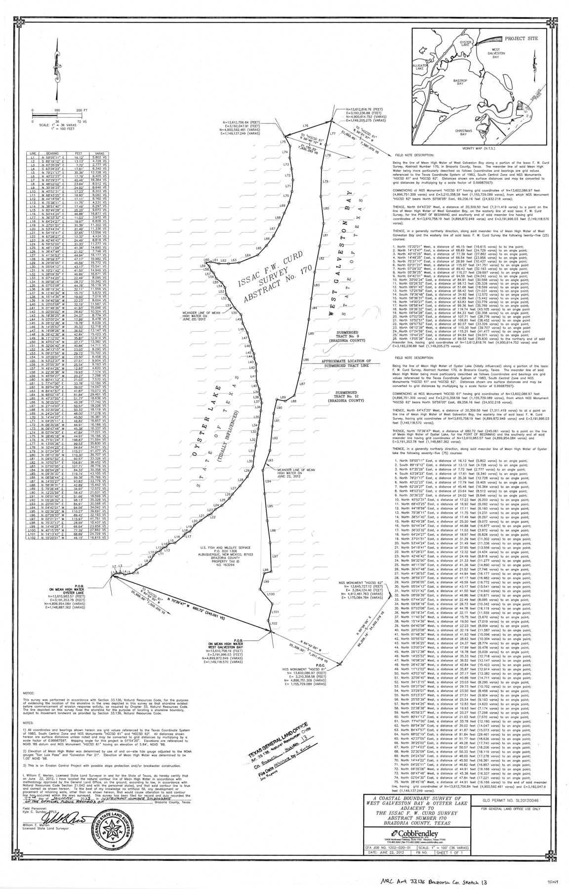
Brazoria County NRC Article 33.136 Sketch 13
A Coastal Boundary Survey of West Galveston Bay & Oyster Lake adjacent to the Issac F.W. Curd survey abstract number 170
-
Map/Doc
95069
-
Collection
General Map Collection
-
Object Dates
2012/6/22 (Creation Date)
2018/6/20 (File Date)
-
People and Organizations
William E. Merten (Surveyor/Engineer)
-
Counties
Brazoria
-
Subjects
Surveying CBS
-
Height x Width
36.0 x 23.0 inches
91.4 x 58.4 cm
-
Medium
multi-page, multi-format
-
Comments
Project: Oyster Lake Shoreline Protection & Marsh Restoration Project No.: SL20120046 (GLO)
Part of: General Map Collection
Vias de Comunicacion y Movimiento Maritimo

Print $20.00
- Digital $50.00
Vias de Comunicacion y Movimiento Maritimo
Size 26.1 x 34.2 inches
Map/Doc 96800
Starr County Sketch File 17

Print $24.00
- Digital $50.00
Starr County Sketch File 17
1880
Size 12.8 x 8.2 inches
Map/Doc 36874
Hockley County

Print $20.00
- Digital $50.00
Hockley County
1954
Size 41.0 x 36.4 inches
Map/Doc 77313
Red River County Working Sketch 8

Print $20.00
- Digital $50.00
Red River County Working Sketch 8
1920
Size 16.2 x 14.2 inches
Map/Doc 71991
Pecos County Sketch File 31

Print $20.00
- Digital $50.00
Pecos County Sketch File 31
1931
Size 14.3 x 32.4 inches
Map/Doc 12173
Pecos County Rolled Sketch 82

Print $20.00
- Digital $50.00
Pecos County Rolled Sketch 82
1930
Size 28.4 x 25.7 inches
Map/Doc 10190

Nautical Chart 11332 - Intracoastal Waterway - Galveston Bay to Cedar Lakes

Print $40.00
- Digital $50.00
Nautical Chart 11332 - Intracoastal Waterway - Galveston Bay to Cedar Lakes
1984
Size 22.3 x 60.3 inches
Map/Doc 69940
Padre Island National Seashore

Print $4.00
- Digital $50.00
Padre Island National Seashore
Size 16.0 x 22.2 inches
Map/Doc 60525
Controlled Mosaic by Jack Amman Photogrammetric Engineers, Inc - Sheet 20

Print $20.00
- Digital $50.00
Controlled Mosaic by Jack Amman Photogrammetric Engineers, Inc - Sheet 20
1954
Size 20.0 x 24.0 inches
Map/Doc 83467
Presidio County Rolled Sketch 131A

Print $20.00
- Digital $50.00
Presidio County Rolled Sketch 131A
Size 47.5 x 36.6 inches
Map/Doc 10711
Nueces County NRC Article 33.136 Location Key Sheet

Print $20.00
- Digital $50.00
Nueces County NRC Article 33.136 Location Key Sheet
1975
Size 27.0 x 23.0 inches
Map/Doc 88585
You may also like
Flight Mission No. DQN-1K, Frame 67, Calhoun County

Print $20.00
- Digital $50.00
Flight Mission No. DQN-1K, Frame 67, Calhoun County
1953
Size 18.3 x 22.1 inches
Map/Doc 84154
Jefferson County Rolled Sketch 7

Print $20.00
- Digital $50.00
Jefferson County Rolled Sketch 7
1928
Size 30.8 x 34.2 inches
Map/Doc 9272
The Judicial District/County of Menard. December 7, 1841

Print $20.00
The Judicial District/County of Menard. December 7, 1841
2020
Size 22.4 x 21.7 inches
Map/Doc 96336
Wichita County Sketch File G

Print $4.00
- Digital $50.00
Wichita County Sketch File G
1882
Size 12.8 x 8.3 inches
Map/Doc 40087
Kent County Sketch File 1

Print $6.00
- Digital $50.00
Kent County Sketch File 1
1882
Size 10.9 x 12.2 inches
Map/Doc 28823
Travis County Sketch File 2

Print $4.00
- Digital $50.00
Travis County Sketch File 2
1851
Size 8.2 x 9.9 inches
Map/Doc 38271
Liberty County Sketch File 64

Print $4.00
- Digital $50.00
Liberty County Sketch File 64
1873
Size 9.9 x 7.9 inches
Map/Doc 30126
Supreme Court of the United States, October Term, 1923, No. 15, Original - The State of Oklahoma, Complainant vs. The State of Texas, Defendant, The United States, Intervener; Report of the Boundary Commissioners

Print $20.00
- Digital $50.00
Supreme Court of the United States, October Term, 1923, No. 15, Original - The State of Oklahoma, Complainant vs. The State of Texas, Defendant, The United States, Intervener; Report of the Boundary Commissioners
1923
Size 34.2 x 33.9 inches
Map/Doc 75133
Dickens County Sketch File 21

Print $20.00
- Digital $50.00
Dickens County Sketch File 21
1911
Size 16.0 x 12.8 inches
Map/Doc 11324
Delta County Sketch File 2

Print $4.00
- Digital $50.00
Delta County Sketch File 2
1871
Size 8.4 x 13.2 inches
Map/Doc 20670
Scurry County Rolled Sketch 5

Print $40.00
- Digital $50.00
Scurry County Rolled Sketch 5
Size 48.4 x 41.1 inches
Map/Doc 9913
Cameron County Rolled Sketch Z7

Print $20.00
- Digital $50.00
Cameron County Rolled Sketch Z7
1937
Size 28.3 x 34.1 inches
Map/Doc 5405