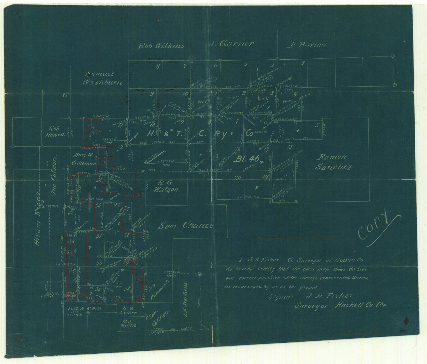
Haskell County Sketch File 1A
[Sketch of H. & T. C. RR. Co. Block 46]
-
Map/Doc
26119
-
Collection
General Map Collection
-
Object Dates
1899/8/23 (File Date)
-
People and Organizations
J.A. Fisher (Surveyor/Engineer)
-
Counties
Haskell Knox Baylor Throckmorton
-
Subjects
Surveying Sketch File
-
Height x Width
12.3 x 14.5 inches
31.2 x 36.8 cm
-
Medium
blueprint/diazo
-
Features
Brushy Creek
South Brushy Creek
Part of: General Map Collection
Presidio County Working Sketch 25

Print $20.00
- Digital $50.00
Presidio County Working Sketch 25
1945
Size 22.8 x 18.9 inches
Map/Doc 71701
Edwards County Boundary File 1

Print $18.00
- Digital $50.00
Edwards County Boundary File 1
Size 15.5 x 5.5 inches
Map/Doc 52853
Galveston Bay and Approaches

Print $20.00
- Digital $50.00
Galveston Bay and Approaches
1938
Size 45.4 x 34.6 inches
Map/Doc 69875
Zavala County Boundary File 1

Print $48.00
- Digital $50.00
Zavala County Boundary File 1
Size 12.8 x 8.3 inches
Map/Doc 60233
Bowie County Sketch File 6d

Print $4.00
- Digital $50.00
Bowie County Sketch File 6d
1927
Size 11.4 x 9.0 inches
Map/Doc 14850
Flight Mission No. DIX-5P, Frame 111, Aransas County

Print $20.00
- Digital $50.00
Flight Mission No. DIX-5P, Frame 111, Aransas County
1956
Size 17.6 x 18.0 inches
Map/Doc 83790
Flight Mission No. BRE-3P, Frame 80, Nueces County

Print $20.00
- Digital $50.00
Flight Mission No. BRE-3P, Frame 80, Nueces County
1956
Size 18.7 x 22.6 inches
Map/Doc 86821
Sabine County Working Sketch 4

Print $20.00
- Digital $50.00
Sabine County Working Sketch 4
1913
Size 23.7 x 32.0 inches
Map/Doc 63675
Brewster County Working Sketch 40

Print $20.00
- Digital $50.00
Brewster County Working Sketch 40
1944
Size 16.1 x 26.1 inches
Map/Doc 67574
Township No. 4 South Range No. 15 West of the Indian Meridian

Print $4.00
- Digital $50.00
Township No. 4 South Range No. 15 West of the Indian Meridian
1875
Size 17.9 x 22.4 inches
Map/Doc 75151
Controlled Mosaic by Jack Amman Photogrammetric Engineers, Inc - Sheet 20

Print $20.00
- Digital $50.00
Controlled Mosaic by Jack Amman Photogrammetric Engineers, Inc - Sheet 20
1954
Size 19.3 x 24.0 inches
Map/Doc 83469
Crockett County Rolled Sketch 64

Print $20.00
- Digital $50.00
Crockett County Rolled Sketch 64
1947
Size 19.8 x 41.2 inches
Map/Doc 5607
You may also like
[Beaumont, Sour Lake and Western Ry. Right of Way and Alignment - Frisco]
![64121, [Beaumont, Sour Lake and Western Ry. Right of Way and Alignment - Frisco], General Map Collection](https://historictexasmaps.com/wmedia_w700/maps/64121.tif.jpg)
Print $20.00
- Digital $50.00
[Beaumont, Sour Lake and Western Ry. Right of Way and Alignment - Frisco]
1910
Size 20.0 x 45.8 inches
Map/Doc 64121
[Block C-41, Section 37, Dawson County, Texas]
![92629, [Block C-41, Section 37, Dawson County, Texas], Twichell Survey Records](https://historictexasmaps.com/wmedia_w700/maps/92629-1.tif.jpg)
Print $20.00
- Digital $50.00
[Block C-41, Section 37, Dawson County, Texas]
1950
Size 14.3 x 12.6 inches
Map/Doc 92629
Bee County Sketch File Y

Print $4.00
- Digital $50.00
Bee County Sketch File Y
Size 8.8 x 5.4 inches
Map/Doc 14255

Crane County Boundary File 1b

Print $80.00
- Digital $50.00
Crane County Boundary File 1b
Size 85.1 x 17.9 inches
Map/Doc 51969
Map of Bexar County

Print $20.00
- Digital $50.00
Map of Bexar County
1896
Size 46.2 x 39.9 inches
Map/Doc 4766
Sabine Bank to East Bay including Heald Bank

Print $20.00
- Digital $50.00
Sabine Bank to East Bay including Heald Bank
1967
Size 45.1 x 34.3 inches
Map/Doc 69848
[Leagues 444, 445, 447, 426 1/2, 464-469, Gregg County School Land Leagues 1 and 2, part of Block B]
![91554, [Leagues 444, 445, 447, 426 1/2, 464-469, Gregg County School Land Leagues 1 and 2, part of Block B], Twichell Survey Records](https://historictexasmaps.com/wmedia_w700/maps/91554-1.tif.jpg)
Print $20.00
- Digital $50.00
[Leagues 444, 445, 447, 426 1/2, 464-469, Gregg County School Land Leagues 1 and 2, part of Block B]
Size 13.4 x 14.0 inches
Map/Doc 91554
Map of Webb Co.

Print $20.00
- Digital $50.00
Map of Webb Co.
1901
Size 40.4 x 47.1 inches
Map/Doc 16919
Galveston County NRC Article 33.136 Sketch 50

Print $24.00
- Digital $50.00
Galveston County NRC Article 33.136 Sketch 50
2008
Size 24.0 x 36.3 inches
Map/Doc 88750
Duval County Sketch File 33

Print $55.00
- Digital $50.00
Duval County Sketch File 33
1932
Size 14.4 x 8.8 inches
Map/Doc 21342
Gray County Boundary File 4

Print $34.00
- Digital $50.00
Gray County Boundary File 4
Size 11.4 x 8.9 inches
Map/Doc 53876