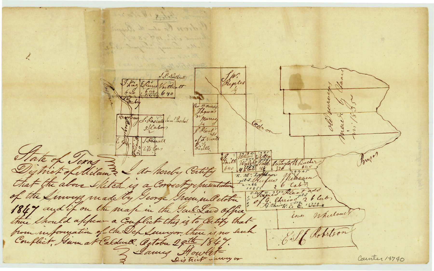
Bosque County Sketch File 2
[Sketch of area near Cedron Creek between the Bosque and Brazos Rivers]
-
Map/Doc
14740
-
Collection
General Map Collection
-
Object Dates
1847/11/19 (File Date)
1847/10/29 (Creation Date)
1847 (Survey Date)
-
People and Organizations
James Howlet (Surveyor/Engineer)
George Green (Surveyor/Engineer)
-
Counties
Bosque
-
Subjects
Surveying Sketch File
-
Height x Width
7.8 x 12.4 inches
19.8 x 31.5 cm
-
Medium
paper, manuscript
-
Features
Cedron Creek
Brazos River
Bosque River
Part of: General Map Collection
Plat of Re-survey Section 8, Block 66 1/2, Public School Land

Print $2.00
- Digital $50.00
Plat of Re-survey Section 8, Block 66 1/2, Public School Land
1972
Size 11.3 x 8.7 inches
Map/Doc 60299
A Topographical Map of the City of Austin

Print $20.00
- Digital $50.00
A Topographical Map of the City of Austin
1872
Size 20.6 x 15.1 inches
Map/Doc 93685
Harris County Texas

Print $20.00
- Digital $50.00
Harris County Texas
1908
Size 19.7 x 24.7 inches
Map/Doc 11652
Map of Nacogdoches County

Print $20.00
- Digital $50.00
Map of Nacogdoches County
1881
Size 25.2 x 20.7 inches
Map/Doc 4601
Cooke County Sketch File 43

Print $28.00
- Digital $50.00
Cooke County Sketch File 43
Size 14.4 x 8.7 inches
Map/Doc 19320
Lamar County Sketch File 15

Print $134.00
- Digital $50.00
Lamar County Sketch File 15
1989
Size 14.5 x 9.1 inches
Map/Doc 29310

Flight Mission No. CGI-1N, Frame 169, Cameron County

Print $20.00
- Digital $50.00
Flight Mission No. CGI-1N, Frame 169, Cameron County
1955
Size 18.6 x 22.2 inches
Map/Doc 84504
Culberson County Sketch File 5

Print $4.00
- Digital $50.00
Culberson County Sketch File 5
Size 9.4 x 8.2 inches
Map/Doc 20136
Presidio County Rolled Sketch 87

Print $20.00
- Digital $50.00
Presidio County Rolled Sketch 87
Size 26.4 x 38.2 inches
Map/Doc 7373
Flight Mission No. DQN-3K, Frame 68, Calhoun County

Print $20.00
- Digital $50.00
Flight Mission No. DQN-3K, Frame 68, Calhoun County
1953
Size 18.5 x 22.3 inches
Map/Doc 84359
Hardin County Working Sketch 31

Print $20.00
- Digital $50.00
Hardin County Working Sketch 31
1971
Size 43.0 x 33.2 inches
Map/Doc 63429
You may also like
[I. Killough and Hiram Cates surveys and vicinity]
![91845, [I. Killough and Hiram Cates surveys and vicinity], Twichell Survey Records](https://historictexasmaps.com/wmedia_w700/maps/91845-1.tif.jpg)
Print $3.00
- Digital $50.00
[I. Killough and Hiram Cates surveys and vicinity]
Size 16.9 x 10.5 inches
Map/Doc 91845
Kent County Sketch File 9

Print $8.00
- Digital $50.00
Kent County Sketch File 9
Size 10.3 x 8.1 inches
Map/Doc 28832
Presidio County Rolled Sketch 56

Print $20.00
- Digital $50.00
Presidio County Rolled Sketch 56
1915
Size 21.8 x 17.1 inches
Map/Doc 7349
Flight Mission No. DAH-9M, Frame 87, Orange County

Print $20.00
- Digital $50.00
Flight Mission No. DAH-9M, Frame 87, Orange County
1953
Size 18.5 x 22.3 inches
Map/Doc 86851
Preliminary Chart of the Northwestern Part of the Gulf of Mexico

Print $20.00
Preliminary Chart of the Northwestern Part of the Gulf of Mexico
1855
Size 32.3 x 41.6 inches
Map/Doc 79334
Fractional Township No. 8 South Range No. 18 East of the Indian Meridian, Indian Territory

Print $20.00
- Digital $50.00
Fractional Township No. 8 South Range No. 18 East of the Indian Meridian, Indian Territory
1897
Size 19.2 x 24.3 inches
Map/Doc 75233
Gray County Boundary File 9

Print $6.00
- Digital $50.00
Gray County Boundary File 9
Size 11.6 x 9.1 inches
Map/Doc 53902
Gonzales County

Print $20.00
- Digital $50.00
Gonzales County
1880
Size 26.3 x 24.0 inches
Map/Doc 4550
Flight Mission No. DQN-6K, Frame 15, Calhoun County

Print $20.00
- Digital $50.00
Flight Mission No. DQN-6K, Frame 15, Calhoun County
1953
Size 18.4 x 22.2 inches
Map/Doc 84437
[Sketch from Burnet Co. to Baylor Co. tying center of counties to county site]
![1699, [Sketch from Burnet Co. to Baylor Co. tying center of counties to county site], General Map Collection](https://historictexasmaps.com/wmedia_w700/maps/1699.tif.jpg)
Print $40.00
- Digital $50.00
[Sketch from Burnet Co. to Baylor Co. tying center of counties to county site]
1900
Size 132.6 x 31.9 inches
Map/Doc 1699
Duval County Boundary File 1a

Print $18.00
- Digital $50.00
Duval County Boundary File 1a
Size 12.8 x 8.4 inches
Map/Doc 52670
[Sketch showing various County School Land Leagues]
![89736, [Sketch showing various County School Land Leagues], Twichell Survey Records](https://historictexasmaps.com/wmedia_w700/maps/89736-1.tif.jpg)
Print $40.00
- Digital $50.00
[Sketch showing various County School Land Leagues]
Size 60.6 x 38.5 inches
Map/Doc 89736