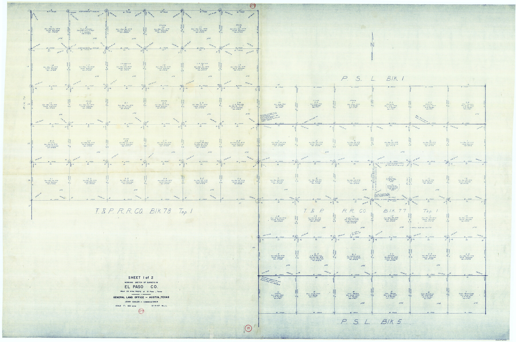
El Paso County Working Sketch 29
-
Map/Doc
69051
-
Collection
General Map Collection
-
Object Dates
12/4/1967 (Creation Date)
-
People and Organizations
M. L. Liles (Draftsman)
-
Counties
El Paso
-
Subjects
Surveying Working Sketch
-
Height x Width
43.0 x 64.8 inches
109.2 x 164.6 cm
-
Scale
1" = 400 varas
Part of: General Map Collection
Gregg County Rolled Sketch RGA

Print $46.00
- Digital $50.00
Gregg County Rolled Sketch RGA
1933
Size 34.3 x 30.6 inches
Map/Doc 9026
Tyler County Working Sketch 10

Print $20.00
- Digital $50.00
Tyler County Working Sketch 10
1937
Size 24.0 x 24.1 inches
Map/Doc 69480
Chambers County Sketch File 57

Print $13.00
- Digital $50.00
Chambers County Sketch File 57
1935
Size 14.7 x 8.9 inches
Map/Doc 18102
Carta Etnografica

Print $20.00
- Digital $50.00
Carta Etnografica
1897
Size 26.2 x 34.1 inches
Map/Doc 96798
Williamson County Sketch File 10

Print $22.00
- Digital $50.00
Williamson County Sketch File 10
1858
Size 12.2 x 17.1 inches
Map/Doc 40322
Winkler County Rolled Sketch CE-1

Print $20.00
- Digital $50.00
Winkler County Rolled Sketch CE-1
1936
Size 36.8 x 35.5 inches
Map/Doc 10149
Map of Comal County

Print $20.00
- Digital $50.00
Map of Comal County
1897
Size 40.0 x 45.8 inches
Map/Doc 66780
Goliad County Sketch File 21

Print $10.00
- Digital $50.00
Goliad County Sketch File 21
1855
Size 12.0 x 7.9 inches
Map/Doc 24284

Culberson County Sketch File WJ2

Print $20.00
- Digital $50.00
Culberson County Sketch File WJ2
Size 15.5 x 20.3 inches
Map/Doc 5788
Travis County Rolled Sketch 11

Print $20.00
- Digital $50.00
Travis County Rolled Sketch 11
Size 23.3 x 37.9 inches
Map/Doc 8014
[Location St. L. & S. W. R. R. Through Cherokee County]
![64042, [Location St. L. & S. W. R. R. Through Cherokee County], General Map Collection](https://historictexasmaps.com/wmedia_w700/maps/64042-1.tif.jpg)
Print $40.00
- Digital $50.00
[Location St. L. & S. W. R. R. Through Cherokee County]
Size 92.0 x 39.9 inches
Map/Doc 64042
You may also like

[H. & T. C. Block 47 and part of G. & M. Block 3]
![91817, [H. & T. C. Block 47 and part of G. & M. Block 3], Twichell Survey Records](https://historictexasmaps.com/wmedia_w700/maps/91817-1.tif.jpg)
Print $20.00
- Digital $50.00
[H. & T. C. Block 47 and part of G. & M. Block 3]
Size 29.4 x 27.9 inches
Map/Doc 91817
Kimble County Sketch File 36

Print $20.00
- Digital $50.00
Kimble County Sketch File 36
1963
Size 22.2 x 25.0 inches
Map/Doc 11932
Newton County Working Sketch 35

Print $20.00
- Digital $50.00
Newton County Working Sketch 35
1969
Size 37.4 x 32.3 inches
Map/Doc 71281
[Lgs. 180-183, 196-198, 105-112, 678-680, 699-701, 141-143]
![90160, [Lgs. 180-183, 196-198, 105-112, 678-680, 699-701, 141-143], Twichell Survey Records](https://historictexasmaps.com/wmedia_w700/maps/90160-1.tif.jpg)
Print $20.00
- Digital $50.00
[Lgs. 180-183, 196-198, 105-112, 678-680, 699-701, 141-143]
1913
Size 28.6 x 19.1 inches
Map/Doc 90160
Jack County Sketch File 6

Print $8.00
- Digital $50.00
Jack County Sketch File 6
1856
Size 8.2 x 3.5 inches
Map/Doc 27513
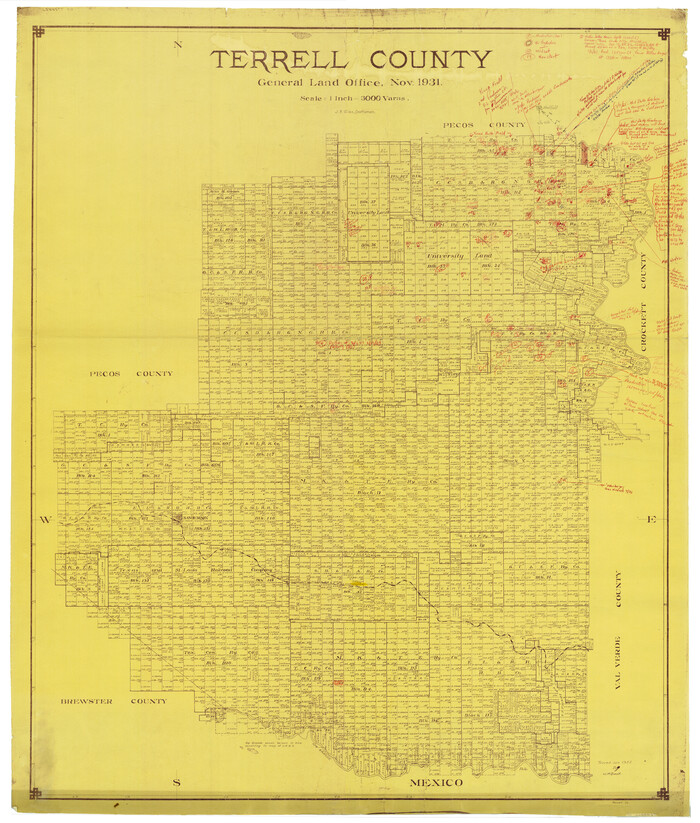
Terrell County Rolled Sketch 58
Print $40.00
- Digital $50.00
Terrell County Rolled Sketch 58
1931
Size 49.1 x 41.8 inches
Map/Doc 9993
Upton County Sketch File 24

Print $4.00
- Digital $50.00
Upton County Sketch File 24
1928
Size 11.3 x 8.8 inches
Map/Doc 38879
Township No. 5 South Range No. 15 West, Indian Meridian, Oklahoma

Print $4.00
- Digital $50.00
Township No. 5 South Range No. 15 West, Indian Meridian, Oklahoma
1927
Size 18.2 x 23.9 inches
Map/Doc 75136
Fannin County Sketch File 16

Print $4.00
- Digital $50.00
Fannin County Sketch File 16
1873
Size 8.1 x 10.3 inches
Map/Doc 22469
San Saba County Working Sketch 6

Print $20.00
- Digital $50.00
San Saba County Working Sketch 6
1959
Size 17.5 x 23.4 inches
Map/Doc 63794
Tom Green County Sketch File 77

Print $6.00
- Digital $50.00
Tom Green County Sketch File 77
Size 10.0 x 8.5 inches
Map/Doc 38253