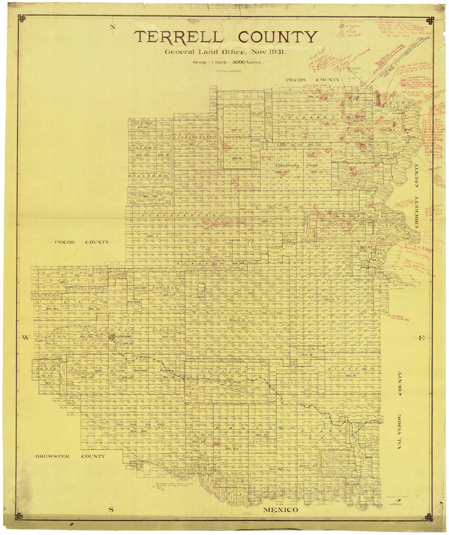
Terrell County Rolled Sketch 58
Terrell County
-
Map/Doc
9993
-
Collection
General Map Collection
-
Object Dates
11/1931 (Creation Date)
-
People and Organizations
J.B. Giles (Draftsman)
-
Counties
Terrell
-
Subjects
Surveying Rolled Sketch
-
Height x Width
49.1 x 41.8 inches
124.7 x 106.2 cm
-
Medium
blueprint/diazo
-
Scale
1" = 3000 varas
Part of: General Map Collection
Crockett County Working Sketch 40

Print $20.00
- Digital $50.00
Crockett County Working Sketch 40
1928
Size 29.5 x 23.7 inches
Map/Doc 68373
Flight Mission No. CRC-1R, Frame 36, Chambers County

Print $20.00
- Digital $50.00
Flight Mission No. CRC-1R, Frame 36, Chambers County
1956
Size 18.7 x 22.3 inches
Map/Doc 84704
Val Verde County Sketch File N

Print $14.00
- Digital $50.00
Val Verde County Sketch File N
1920
Size 10.9 x 8.8 inches
Map/Doc 39284
Collin County Working Sketch 4

Print $20.00
- Digital $50.00
Collin County Working Sketch 4
1953
Size 20.4 x 21.8 inches
Map/Doc 68098
[Sketch in DeWitt County]
![78383, [Sketch in DeWitt County], General Map Collection](https://historictexasmaps.com/wmedia_w700/maps/78383.tif.jpg)
Print $3.00
- Digital $50.00
[Sketch in DeWitt County]
Size 9.3 x 10.1 inches
Map/Doc 78383
Oldham County

Print $40.00
- Digital $50.00
Oldham County
1925
Size 41.5 x 53.2 inches
Map/Doc 95604

Duval County Rolled Sketch 33A

Print $40.00
- Digital $50.00
Duval County Rolled Sketch 33A
1949
Size 43.8 x 79.5 inches
Map/Doc 8818
Shackelford County Working Sketch 2

Print $20.00
- Digital $50.00
Shackelford County Working Sketch 2
1914
Size 17.2 x 17.3 inches
Map/Doc 63842
Bell County Sketch File 18

Print $4.00
- Digital $50.00
Bell County Sketch File 18
1870
Size 7.9 x 9.0 inches
Map/Doc 14400
Jefferson County Working Sketch 9

Print $20.00
- Digital $50.00
Jefferson County Working Sketch 9
1937
Size 19.5 x 22.0 inches
Map/Doc 66552
Pecos County Rolled Sketch 39A

Print $20.00
- Digital $50.00
Pecos County Rolled Sketch 39A
1908
Size 23.8 x 35.9 inches
Map/Doc 7218
You may also like
Donley County Boundary File 2

Print $10.00
- Digital $50.00
Donley County Boundary File 2
Size 8.7 x 11.3 inches
Map/Doc 52619
Fort Bend County Rolled Sketch A

Print $20.00
- Digital $50.00
Fort Bend County Rolled Sketch A
1900
Size 19.8 x 29.7 inches
Map/Doc 5903
Sketch of Section 3, Blk. JW, Showing Quantity East of Each Texas Section

Print $20.00
- Digital $50.00
Sketch of Section 3, Blk. JW, Showing Quantity East of Each Texas Section
Size 34.2 x 8.0 inches
Map/Doc 91985
Duval County Sketch File 34

Print $20.00
- Digital $50.00
Duval County Sketch File 34
Size 28.4 x 36.9 inches
Map/Doc 11391
Upshur County Sketch File 22

Print $8.00
- Digital $50.00
Upshur County Sketch File 22
2015
Size 11.0 x 8.5 inches
Map/Doc 93774
Andrews County Working Sketch 15

Print $40.00
- Digital $50.00
Andrews County Working Sketch 15
1957
Size 50.5 x 36.1 inches
Map/Doc 67061
Sketch of Surveys on Caranchua and Tres Palacious Bayous, Jackson Co.

Print $2.00
- Digital $50.00
Sketch of Surveys on Caranchua and Tres Palacious Bayous, Jackson Co.
Size 7.9 x 7.8 inches
Map/Doc 69743
Sabine Pass and Lake

Print $20.00
- Digital $50.00
Sabine Pass and Lake
1975
Size 46.9 x 27.8 inches
Map/Doc 69827
Map of subdivision of submerged land in the Gulf of Mexico fronting on Matagorda Island and Peninsula

Print $40.00
- Digital $50.00
Map of subdivision of submerged land in the Gulf of Mexico fronting on Matagorda Island and Peninsula
1940
Size 28.2 x 61.3 inches
Map/Doc 2929
Flight Mission No. CRC-3R, Frame 52, Chambers County

Print $20.00
- Digital $50.00
Flight Mission No. CRC-3R, Frame 52, Chambers County
1956
Size 18.7 x 22.3 inches
Map/Doc 89041
Culberson County Sketch File 15

Print $20.00
- Digital $50.00
Culberson County Sketch File 15
1933
Size 30.4 x 24.4 inches
Map/Doc 11267
Cherokee County Sketch File 21

Print $4.00
- Digital $50.00
Cherokee County Sketch File 21
1876
Size 8.0 x 7.4 inches
Map/Doc 18165