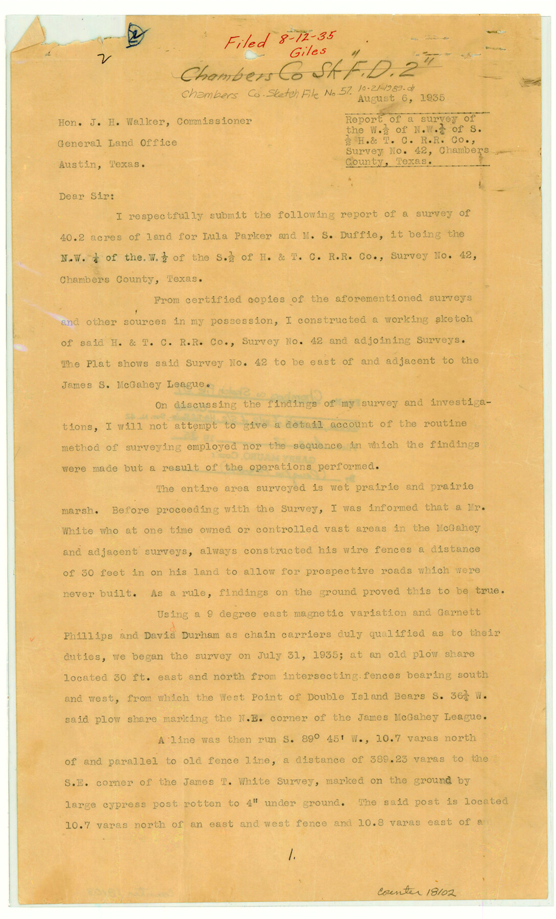
Chambers County Sketch File 57
[Report of a survey of the west 1/2 of northwest 1/4 of the south 1/2 H. & T. C. RR. Co. survey no. 42]
Chambers County Rolled Sketch FD2
-
Map/Doc
18102
-
Collection
General Map Collection
-
Object Dates
1935/8/12 (Creation Date)
-
People and Organizations
Forrest Daniell (Surveyor/Engineer)
-
Counties
Chambers
-
Subjects
Surveying Sketch File
-
Height x Width
14.7 x 8.9 inches
37.3 x 22.6 cm
-
Medium
paper, print
-
Comments
See Chambers County Rolled Sketch FD2 (5434) for sketch.
-
Features
Double Island
Double Bayou
Related maps
Chambers County Rolled Sketch FD2

Print $20.00
- Digital $50.00
Chambers County Rolled Sketch FD2
1935
Size 15.3 x 19.7 inches
Map/Doc 5434
Part of: General Map Collection
Hunt County Sketch File 9

Print $3.00
- Digital $50.00
Hunt County Sketch File 9
1851
Size 10.0 x 14.8 inches
Map/Doc 27099
Ochiltree County Rolled Sketch 2

Print $20.00
- Digital $50.00
Ochiltree County Rolled Sketch 2
Size 23.0 x 17.7 inches
Map/Doc 7172
Lavaca County Sketch File 9

Print $22.00
- Digital $50.00
Lavaca County Sketch File 9
Size 7.2 x 13.4 inches
Map/Doc 29646
Dallam County Sketch File 6

Print $60.00
- Digital $50.00
Dallam County Sketch File 6
Size 12.4 x 17.0 inches
Map/Doc 20350
Austin County Sketch File 6b

Print $50.00
- Digital $50.00
Austin County Sketch File 6b
1894
Size 11.3 x 8.6 inches
Map/Doc 13872
North Part of El Paso Co.

Print $20.00
- Digital $50.00
North Part of El Paso Co.
1977
Size 35.7 x 46.3 inches
Map/Doc 73141
Culberson County Working Sketch 12

Print $20.00
- Digital $50.00
Culberson County Working Sketch 12
1922
Size 20.9 x 17.8 inches
Map/Doc 68464
Bowie County Working Sketch 6

Print $20.00
- Digital $50.00
Bowie County Working Sketch 6
1928
Size 27.4 x 22.9 inches
Map/Doc 67410
Flight Mission No. DQN-2K, Frame 114, Calhoun County

Print $20.00
- Digital $50.00
Flight Mission No. DQN-2K, Frame 114, Calhoun County
1953
Size 18.5 x 22.2 inches
Map/Doc 84290
Presidio County Sketch File 89

Print $10.00
- Digital $50.00
Presidio County Sketch File 89
1953
Size 14.3 x 8.9 inches
Map/Doc 34756
Newton County Rolled Sketch 19

Print $20.00
- Digital $50.00
Newton County Rolled Sketch 19
1956
Size 42.1 x 33.5 inches
Map/Doc 6848

You may also like
Map of Rusk County

Print $20.00
- Digital $50.00
Map of Rusk County
1846
Size 31.6 x 20.6 inches
Map/Doc 4006
A Portion of the State's Submerged Oil Field, Goose Creek - Harris County - Texas

Print $20.00
- Digital $50.00
A Portion of the State's Submerged Oil Field, Goose Creek - Harris County - Texas
1919
Size 14.2 x 17.3 inches
Map/Doc 3165
Marion County Working Sketch 33

Print $20.00
- Digital $50.00
Marion County Working Sketch 33
1983
Size 16.0 x 20.7 inches
Map/Doc 70809
Stonewall County Working Sketch 1

Print $20.00
- Digital $50.00
Stonewall County Working Sketch 1
1910
Size 30.7 x 22.8 inches
Map/Doc 63995
Starr County Rolled Sketch X

Print $121.00
- Digital $50.00
Starr County Rolled Sketch X
Size 13.3 x 8.1 inches
Map/Doc 75961
Red River County Working Sketch 53

Print $20.00
- Digital $50.00
Red River County Working Sketch 53
1971
Size 23.4 x 26.9 inches
Map/Doc 72036
Old Miscellaneous File 1

Print $172.00
- Digital $50.00
Old Miscellaneous File 1
Size 8.3 x 6.6 inches
Map/Doc 75320
Map of Ohio, Michigan, Indiana and Kentucky

Print $20.00
- Digital $50.00
Map of Ohio, Michigan, Indiana and Kentucky
1885
Size 12.2 x 9.0 inches
Map/Doc 93520
Map of Independence Area, Washington County, Texas

Print $20.00
- Digital $50.00
Map of Independence Area, Washington County, Texas
1935
Size 24.0 x 19.1 inches
Map/Doc 91989
San Jacinto County Working Sketch 31

Print $20.00
- Digital $50.00
San Jacinto County Working Sketch 31
1953
Size 29.1 x 30.4 inches
Map/Doc 63744
Foard County Working Sketch 4

Print $20.00
- Digital $50.00
Foard County Working Sketch 4
1934
Size 29.4 x 27.8 inches
Map/Doc 69194
Mills County Working Sketch 23

Print $20.00
- Digital $50.00
Mills County Working Sketch 23
1985
Size 22.8 x 36.8 inches
Map/Doc 71053