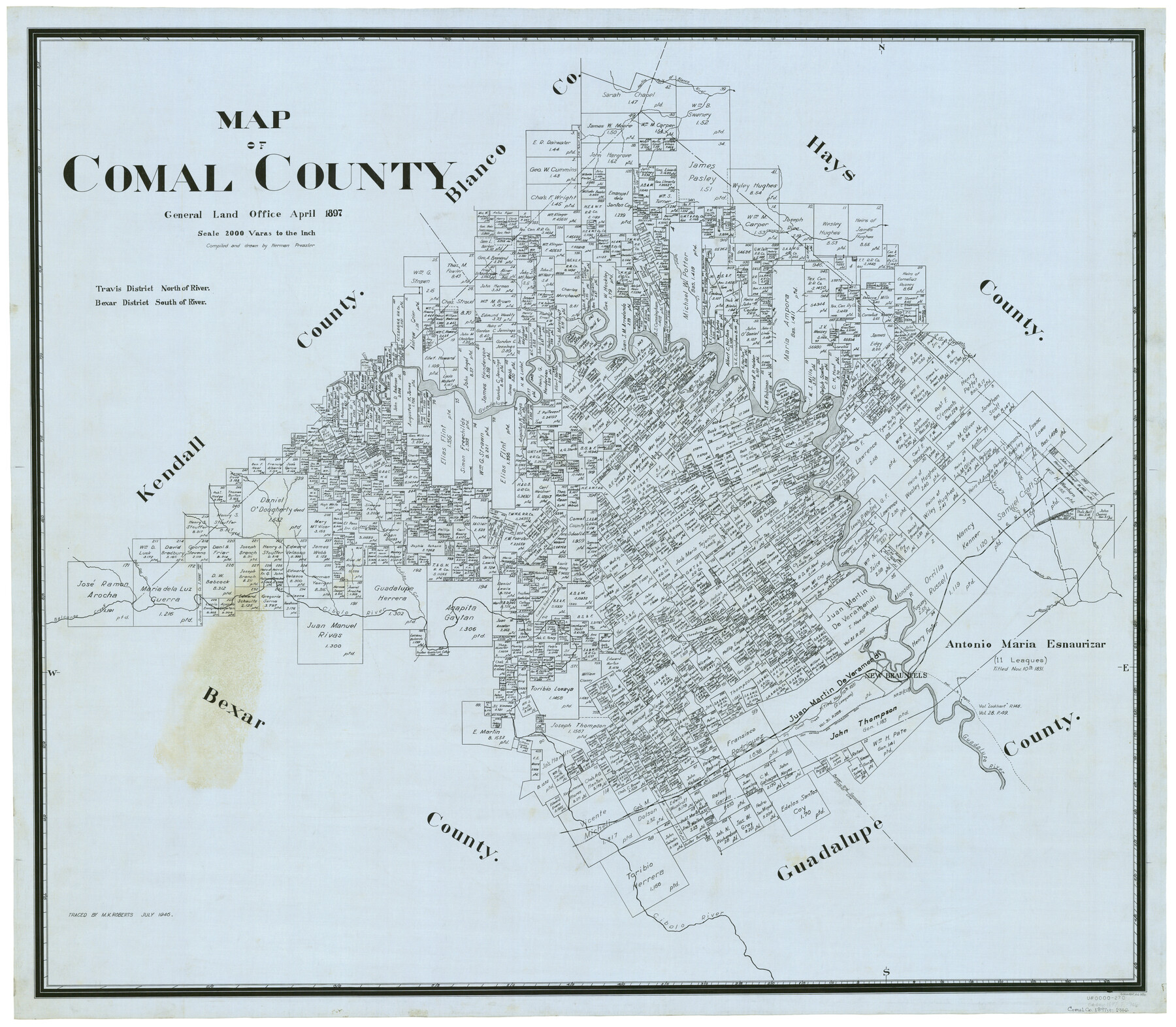
Map of Comal County
-
Map/Doc
66780
-
Collection
General Map Collection
-
Object Dates
4/1897 (Creation Date)
-
People and Organizations
Herman Pressler (Draftsman)
-
Counties
Comal
-
Subjects
County
-
Height x Width
40.0 x 45.8 inches
101.6 x 116.3 cm
-
Comments
Traced in July 1946 by M. K. Roberts.
Part of: General Map Collection
Presidio County Working Sketch 27

Print $20.00
- Digital $50.00
Presidio County Working Sketch 27
1945
Size 32.4 x 13.4 inches
Map/Doc 71703
Jasper County Rolled Sketch 2

Print $20.00
- Digital $50.00
Jasper County Rolled Sketch 2
1941
Size 37.9 x 24.1 inches
Map/Doc 6349
San Jacinto County Working Sketch 31

Print $20.00
- Digital $50.00
San Jacinto County Working Sketch 31
1953
Size 29.1 x 30.4 inches
Map/Doc 63744
St. Louis, Brownsville & Mexico Railway Location Map from Mile 120 to Rio Grande

Print $40.00
- Digital $50.00
St. Louis, Brownsville & Mexico Railway Location Map from Mile 120 to Rio Grande
1905
Size 20.2 x 61.4 inches
Map/Doc 64169
Maverick County Rolled Sketch 13

Print $20.00
- Digital $50.00
Maverick County Rolled Sketch 13
1848
Size 34.4 x 26.5 inches
Map/Doc 6706
Kimble County Sketch File 43

Print $16.00
- Digital $50.00
Kimble County Sketch File 43
2021
Size 11.0 x 8.5 inches
Map/Doc 96811
Brazos River, Brazos River Sheet 3

Print $6.00
- Digital $50.00
Brazos River, Brazos River Sheet 3
1926
Size 23.6 x 35.2 inches
Map/Doc 65295
East Part of Brewster Co.

Print $40.00
- Digital $50.00
East Part of Brewster Co.
1952
Size 49.5 x 31.1 inches
Map/Doc 95436
Dawson County Sketch File 31

Print $4.00
- Digital $50.00
Dawson County Sketch File 31
1989
Size 11.4 x 9.0 inches
Map/Doc 20614
Hartley County

Print $40.00
- Digital $50.00
Hartley County
1902
Size 44.5 x 58.0 inches
Map/Doc 2480
[Surveys in Austin's Colony along Hickory Creek, Hog Creek, and the Yegua River]
![195, [Surveys in Austin's Colony along Hickory Creek, Hog Creek, and the Yegua River], General Map Collection](https://historictexasmaps.com/wmedia_w700/maps/195.tif.jpg)
Print $20.00
- Digital $50.00
[Surveys in Austin's Colony along Hickory Creek, Hog Creek, and the Yegua River]
1831
Size 19.4 x 23.9 inches
Map/Doc 195
Henderson County Rolled Sketch 11

Print $20.00
- Digital $50.00
Henderson County Rolled Sketch 11
1915
Size 29.2 x 41.6 inches
Map/Doc 76147
You may also like

Henderson County Sketch File 9

Print $8.00
- Digital $50.00
Henderson County Sketch File 9
Size 8.3 x 7.8 inches
Map/Doc 26343
Bee County Sketch File 25

Print $4.00
- Digital $50.00
Bee County Sketch File 25
1880
Size 11.0 x 8.2 inches
Map/Doc 14326
Starr County Rolled Sketch 2

Print $40.00
- Digital $50.00
Starr County Rolled Sketch 2
1853
Size 31.7 x 48.5 inches
Map/Doc 9938
Gregg County Sketch File 1A

Print $6.00
- Digital $50.00
Gregg County Sketch File 1A
1847
Size 8.3 x 7.6 inches
Map/Doc 24535
[Military surveys on headwaters of Red River]
![3099, [Military surveys on headwaters of Red River], General Map Collection](https://historictexasmaps.com/wmedia_w700/maps/3099-1.tif.jpg)
Print $20.00
- Digital $50.00
[Military surveys on headwaters of Red River]
1878
Size 31.6 x 39.0 inches
Map/Doc 3099
Hutchinson County Working Sketch 46

Print $20.00
- Digital $50.00
Hutchinson County Working Sketch 46
1979
Size 20.4 x 22.3 inches
Map/Doc 66406
Flight Mission No. BQY-4M, Frame 61, Harris County

Print $20.00
- Digital $50.00
Flight Mission No. BQY-4M, Frame 61, Harris County
1953
Size 18.7 x 22.5 inches
Map/Doc 85270
Flight Mission No. CRK-8P, Frame 117, Refugio County

Print $20.00
- Digital $50.00
Flight Mission No. CRK-8P, Frame 117, Refugio County
1956
Size 18.1 x 22.0 inches
Map/Doc 86972
Cameron County Rolled Sketch 26

Print $20.00
- Digital $50.00
Cameron County Rolled Sketch 26
Size 18.5 x 24.3 inches
Map/Doc 5390
[Texas and New Orleans Railroad Company, Block 2]
![92702, [Texas and New Orleans Railroad Company, Block 2], Twichell Survey Records](https://historictexasmaps.com/wmedia_w700/maps/92702-1.tif.jpg)
Print $20.00
- Digital $50.00
[Texas and New Orleans Railroad Company, Block 2]
1906
Size 21.1 x 14.4 inches
Map/Doc 92702
Foard County Working Sketch 10

Print $20.00
- Digital $50.00
Foard County Working Sketch 10
1977
Size 32.0 x 43.7 inches
Map/Doc 69201