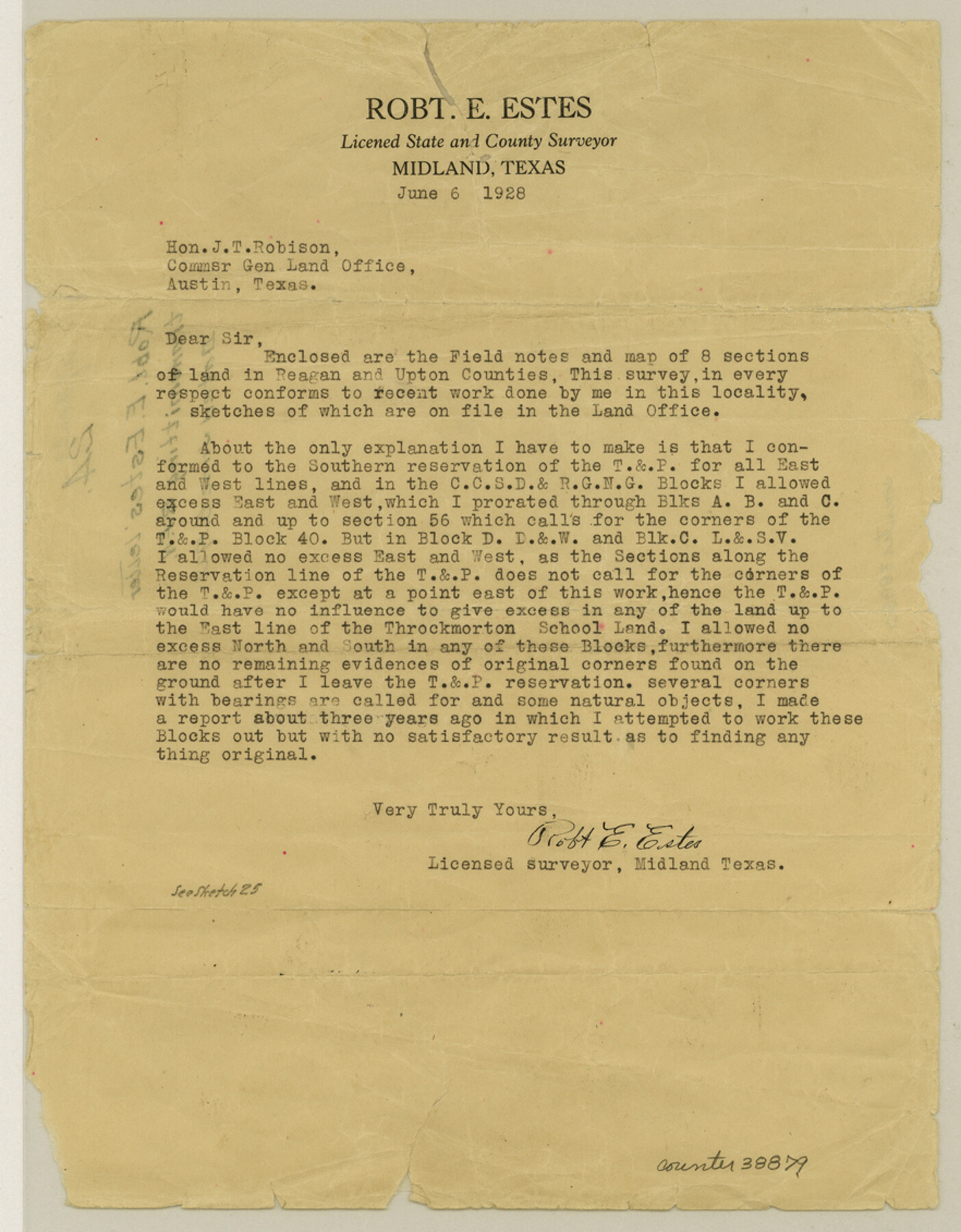
Upton County Sketch File 24
[Letter accompanying field notes]
-
Map/Doc
38879
-
Collection
General Map Collection
-
Object Dates
1928/6/6 (Creation Date)
1928/6/6 (Creation Date)
1928/6/6 (Correspondence Date)
-
People and Organizations
R.E. Estes (Surveyor/Engineer)
Robert E. Estes (Surveyor/Engineer)
-
Counties
Upton
-
Subjects
Surveying Sketch File
-
Height x Width
11.3 x 8.8 inches
28.7 x 22.4 cm
-
Medium
paper, print
Part of: General Map Collection
Motley County Sketch File F (S)

Print $14.00
- Digital $50.00
Motley County Sketch File F (S)
1904
Size 9.1 x 5.9 inches
Map/Doc 32179
Palo Pinto County Rolled Sketch 4

Print $20.00
- Digital $50.00
Palo Pinto County Rolled Sketch 4
Size 15.9 x 23.2 inches
Map/Doc 7189
Flight Mission No. DQN-2K, Frame 88, Calhoun County

Print $20.00
- Digital $50.00
Flight Mission No. DQN-2K, Frame 88, Calhoun County
1953
Size 18.6 x 22.3 inches
Map/Doc 84278
Comanche County Boundary File 2b

Print $12.00
- Digital $50.00
Comanche County Boundary File 2b
Size 14.3 x 8.9 inches
Map/Doc 51790
Tyler County Working Sketch 17

Print $20.00
- Digital $50.00
Tyler County Working Sketch 17
1962
Size 33.1 x 38.9 inches
Map/Doc 69487
Colorado River, New Gulf Sheet

Print $6.00
- Digital $50.00
Colorado River, New Gulf Sheet
1940
Size 24.0 x 34.9 inches
Map/Doc 65315
Knox County Rolled Sketch 20

Print $20.00
- Digital $50.00
Knox County Rolled Sketch 20
Size 31.5 x 23.3 inches
Map/Doc 6560
Flight Mission No. BRA-8M, Frame 88, Jefferson County

Print $20.00
- Digital $50.00
Flight Mission No. BRA-8M, Frame 88, Jefferson County
1953
Size 18.6 x 22.3 inches
Map/Doc 85608
Map of the British Isles to illustrate Olney's school geography (Inset: Shetland Isles)

Print $20.00
- Digital $50.00
Map of the British Isles to illustrate Olney's school geography (Inset: Shetland Isles)
1844
Size 12.1 x 9.5 inches
Map/Doc 93547
Bosque County Sketch File 15

Print $14.00
- Digital $50.00
Bosque County Sketch File 15
1863
Size 12.3 x 7.7 inches
Map/Doc 14774
Dickens County Working Sketch 9

Print $20.00
- Digital $50.00
Dickens County Working Sketch 9
1947
Size 18.5 x 29.6 inches
Map/Doc 68657
Brazoria County

Print $40.00
- Digital $50.00
Brazoria County
1891
Size 47.1 x 54.2 inches
Map/Doc 4890
You may also like
Stephens County Working Sketch 24

Print $20.00
- Digital $50.00
Stephens County Working Sketch 24
1976
Size 39.2 x 31.9 inches
Map/Doc 63967
Presidio County Working Sketch 4

Print $20.00
- Digital $50.00
Presidio County Working Sketch 4
1915
Size 26.3 x 21.7 inches
Map/Doc 71678
Reagan County Working Sketch 44

Print $20.00
- Digital $50.00
Reagan County Working Sketch 44
1987
Size 25.2 x 37.1 inches
Map/Doc 71886
Map of Texas with Parts of the Adjoining States

Print $20.00
Map of Texas with Parts of the Adjoining States
1836
Size 29.5 x 23.6 inches
Map/Doc 76193
Duval County Sketch File 39

Print $20.00
- Digital $50.00
Duval County Sketch File 39
Size 32.1 x 23.9 inches
Map/Doc 11395
Kimble County Sketch File 36

Print $20.00
- Digital $50.00
Kimble County Sketch File 36
1963
Size 22.2 x 25.0 inches
Map/Doc 11932
Medina County Sketch File 22

Print $38.00
- Digital $50.00
Medina County Sketch File 22
2007
Size 11.0 x 8.5 inches
Map/Doc 93633
Starr County Sketch File 50

Print $40.00
- Digital $50.00
Starr County Sketch File 50
1963
Size 12.4 x 15.5 inches
Map/Doc 37007
[Surveys in the Montgomery District: San Jacinto River and Caney Creek, Navidad, Navasota]
![69744, [Surveys in the Montgomery District: San Jacinto River and Caney Creek, Navidad, Navasota], General Map Collection](https://historictexasmaps.com/wmedia_w700/maps/69744.tif.jpg)
Print $2.00
- Digital $50.00
[Surveys in the Montgomery District: San Jacinto River and Caney Creek, Navidad, Navasota]
Size 5.1 x 7.3 inches
Map/Doc 69744
Hardin County

Print $20.00
- Digital $50.00
Hardin County
1940
Size 40.7 x 37.7 inches
Map/Doc 77303
Moore County, Texas

Print $20.00
- Digital $50.00
Moore County, Texas
1888
Size 22.0 x 18.3 inches
Map/Doc 742
Van Zandt County Sketch File 44

Print $4.00
- Digital $50.00
Van Zandt County Sketch File 44
1858
Size 10.1 x 8.1 inches
Map/Doc 39499