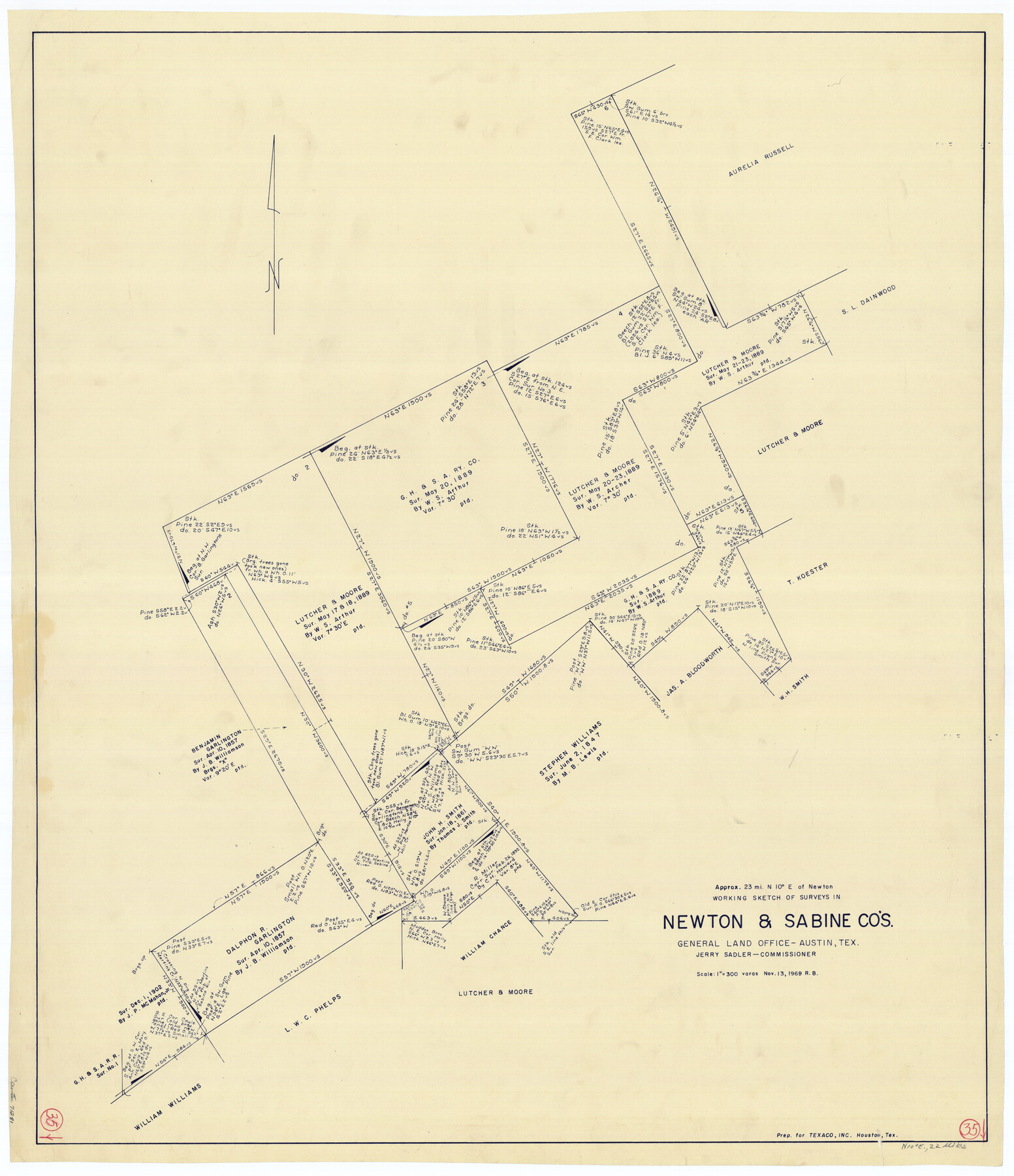
Newton County Working Sketch 35
-
Map/Doc
71281
-
Collection
General Map Collection
-
Object Dates
11/13/1969 (Creation Date)
-
People and Organizations
Roy Buckholts (Draftsman)
-
Counties
Newton Sabine
-
Subjects
Surveying Working Sketch
-
Height x Width
37.4 x 32.3 inches
95.0 x 82.0 cm
-
Scale
1" = 300 varas
Part of: General Map Collection
United States - Gulf Coast - Padre I. and Laguna Madre Lat. 27° 12' to Lat. 26° 33' Texas

Print $20.00
- Digital $50.00
United States - Gulf Coast - Padre I. and Laguna Madre Lat. 27° 12' to Lat. 26° 33' Texas
1913
Size 27.0 x 18.3 inches
Map/Doc 72819
DeWitt County Working Sketch 10

Print $20.00
- Digital $50.00
DeWitt County Working Sketch 10
1980
Size 15.1 x 12.0 inches
Map/Doc 68600
Motley County Sketch File DD (S)

Print $22.00
- Digital $50.00
Motley County Sketch File DD (S)
Size 10.9 x 7.1 inches
Map/Doc 32159
Flight Mission No. CUG-2P, Frame 82, Kleberg County

Print $20.00
- Digital $50.00
Flight Mission No. CUG-2P, Frame 82, Kleberg County
1956
Size 18.5 x 22.3 inches
Map/Doc 86214
Val Verde County Working Sketch 14

Print $20.00
- Digital $50.00
Val Verde County Working Sketch 14
1926
Size 17.2 x 18.9 inches
Map/Doc 72149
Proceedings of The International (Water) Boundary Commission United States and Mexico Treaties of 1884 and 1889, Volume 1

Proceedings of The International (Water) Boundary Commission United States and Mexico Treaties of 1884 and 1889, Volume 1
Map/Doc 83144
Sterling County Working Sketch 11

Print $20.00
- Digital $50.00
Sterling County Working Sketch 11
1987
Size 20.1 x 40.8 inches
Map/Doc 63993
Harris County Rolled Sketch 28(1)

Print $39.00
- Digital $50.00
Harris County Rolled Sketch 28(1)
Size 10.0 x 15.3 inches
Map/Doc 45770
[Sketch for Mineral Application 16700 - Pecos River Bed]
![2807, [Sketch for Mineral Application 16700 - Pecos River Bed], General Map Collection](https://historictexasmaps.com/wmedia_w700/maps/2807.tif.jpg)
Print $20.00
- Digital $50.00
[Sketch for Mineral Application 16700 - Pecos River Bed]
1927
Size 32.9 x 15.3 inches
Map/Doc 2807
Flight Mission No. BQY-4M, Frame 30, Harris County

Print $20.00
- Digital $50.00
Flight Mission No. BQY-4M, Frame 30, Harris County
1953
Size 18.7 x 22.4 inches
Map/Doc 85245
Colorado County Sketch File 7

Print $4.00
- Digital $50.00
Colorado County Sketch File 7
1862
Size 13.1 x 8.0 inches
Map/Doc 18925
Childress County

Print $20.00
- Digital $50.00
Childress County
1883
Size 20.6 x 17.4 inches
Map/Doc 3393
You may also like
Grimes County Working Sketch 13

Print $20.00
- Digital $50.00
Grimes County Working Sketch 13
1982
Size 39.4 x 47.7 inches
Map/Doc 63304
Kinney County Working Sketch 31

Print $20.00
- Digital $50.00
Kinney County Working Sketch 31
1961
Size 30.9 x 47.3 inches
Map/Doc 70213
A Map of Sterling County

Print $20.00
- Digital $50.00
A Map of Sterling County
1919
Size 33.3 x 21.6 inches
Map/Doc 4054
Brewster County Rolled Sketch 138

Print $20.00
- Digital $50.00
Brewster County Rolled Sketch 138
1982
Size 24.5 x 38.0 inches
Map/Doc 5306
Map of Galveston, Turtle & East Bays & Portion of the Gulf of Mexico in Chambers & Galveston Counties, Texas Showing Subdivision Thereof for Mineral Development

Print $40.00
- Digital $50.00
Map of Galveston, Turtle & East Bays & Portion of the Gulf of Mexico in Chambers & Galveston Counties, Texas Showing Subdivision Thereof for Mineral Development
1935
Size 43.6 x 51.1 inches
Map/Doc 78633
Alamo Defenders Heritage Map of Texas

Print $20.00
Alamo Defenders Heritage Map of Texas
2025
Size 36.0 x 24.0 inches
Map/Doc 97433
America's Fun-Tier: Texas 1967 Official State Highway Map

Digital $50.00
America's Fun-Tier: Texas 1967 Official State Highway Map
Size 28.2 x 36.4 inches
Map/Doc 94321

Flight Mission No. CUG-2P, Frame 83, Kleberg County

Print $20.00
- Digital $50.00
Flight Mission No. CUG-2P, Frame 83, Kleberg County
1956
Size 18.5 x 22.3 inches
Map/Doc 86215
Webb County Sketch File 72

Print $24.00
- Digital $50.00
Webb County Sketch File 72
2011
Size 11.0 x 8.5 inches
Map/Doc 90054
Wilbarger County Working Sketch 22

Print $20.00
- Digital $50.00
Wilbarger County Working Sketch 22
1983
Size 39.8 x 33.6 inches
Map/Doc 72560
Hall County Sketch File 6

Print $20.00
- Digital $50.00
Hall County Sketch File 6
1885
Size 28.2 x 37.9 inches
Map/Doc 10473