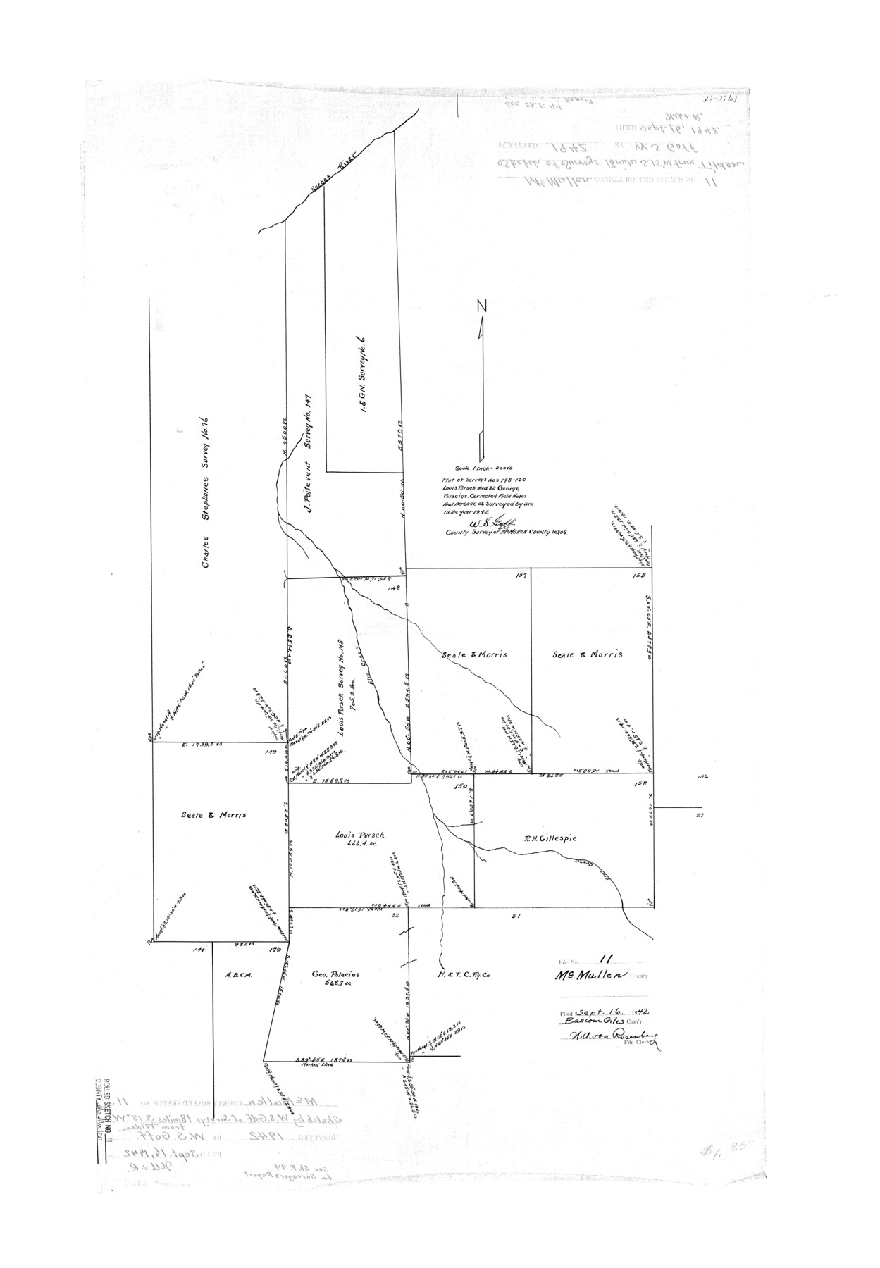
McMullen County Rolled Sketch 11
Plat of surveys nos. 148-150 Louis Pursch and 32 George Palacios
-
Map/Doc
6728
-
Collection
General Map Collection
-
Object Dates
1942 (Survey Date)
1942/9/16 (File Date)
-
People and Organizations
W.S. Goff (Surveyor/Engineer)
-
Counties
McMullen
-
Subjects
Surveying Rolled Sketch
-
Height x Width
32.2 x 22.3 inches
81.8 x 56.6 cm
-
Scale
1" = 500 varas
Part of: General Map Collection
Hunt County Sketch File 37

Print $4.00
- Digital $50.00
Hunt County Sketch File 37
Size 11.4 x 8.1 inches
Map/Doc 27155
Donley County Working Sketch 8

Print $20.00
- Digital $50.00
Donley County Working Sketch 8
1981
Size 36.9 x 46.8 inches
Map/Doc 68741
Flight Mission No. BRE-2P, Frame 75, Nueces County

Print $20.00
- Digital $50.00
Flight Mission No. BRE-2P, Frame 75, Nueces County
1956
Size 18.5 x 22.5 inches
Map/Doc 86770
Wichita County Working Sketch 14

Print $20.00
- Digital $50.00
Wichita County Working Sketch 14
1922
Size 20.8 x 42.1 inches
Map/Doc 72524
Morris County Rolled Sketch 2A

Print $20.00
- Digital $50.00
Morris County Rolled Sketch 2A
Size 24.0 x 18.7 inches
Map/Doc 10272
Hardin County Working Sketch 35

Print $20.00
- Digital $50.00
Hardin County Working Sketch 35
1981
Size 17.2 x 14.6 inches
Map/Doc 63433
Mason County Working Sketch 19

Print $20.00
- Digital $50.00
Mason County Working Sketch 19
1981
Size 27.0 x 37.1 inches
Map/Doc 70855
Moore County Rolled Sketch 8

Print $20.00
- Digital $50.00
Moore County Rolled Sketch 8
1912
Size 33.7 x 35.2 inches
Map/Doc 9548
Nolan County Rolled Sketch 2A

Print $20.00
- Digital $50.00
Nolan County Rolled Sketch 2A
Size 26.9 x 34.8 inches
Map/Doc 6861
[Right of Way and Track Map, the Missouri, Kansas and Texas Ry. of Texas - Henrietta Division]
![64758, [Right of Way and Track Map, the Missouri, Kansas and Texas Ry. of Texas - Henrietta Division], General Map Collection](https://historictexasmaps.com/wmedia_w700/maps/64758.tif.jpg)
Print $20.00
- Digital $50.00
[Right of Way and Track Map, the Missouri, Kansas and Texas Ry. of Texas - Henrietta Division]
1918
Size 11.8 x 26.8 inches
Map/Doc 64758
Flight Mission No. CRC-4R, Frame 72, Chambers County

Print $20.00
- Digital $50.00
Flight Mission No. CRC-4R, Frame 72, Chambers County
1956
Size 18.8 x 22.4 inches
Map/Doc 84876
Index sheet to accompany map of survey for connecting the inland waters along margin of the Gulf of Mexico from Donaldsonville in Louisiana to the Rio Grande River in Texas

Print $20.00
- Digital $50.00
Index sheet to accompany map of survey for connecting the inland waters along margin of the Gulf of Mexico from Donaldsonville in Louisiana to the Rio Grande River in Texas
1874
Size 18.2 x 27.1 inches
Map/Doc 72696
You may also like
Live Oak County Sketch File 21

Print $26.00
- Digital $50.00
Live Oak County Sketch File 21
1912
Size 16.8 x 8.0 inches
Map/Doc 30297
Jasper County Working Sketch 11

Print $20.00
- Digital $50.00
Jasper County Working Sketch 11
1917
Size 20.2 x 23.4 inches
Map/Doc 66473
Map of the Reconnaissance in Texas by Lieuts Blake & Meade of the Corps of Topl. Engrs.

Print $20.00
- Digital $50.00
Map of the Reconnaissance in Texas by Lieuts Blake & Meade of the Corps of Topl. Engrs.
1845
Size 27.6 x 18.2 inches
Map/Doc 72891
Mrs. Don D. Kinnebrew Farm Section 72, Block A

Print $20.00
- Digital $50.00
Mrs. Don D. Kinnebrew Farm Section 72, Block A
Size 15.6 x 18.0 inches
Map/Doc 92290
Angelina County Working Sketch 52

Print $20.00
- Digital $50.00
Angelina County Working Sketch 52
1978
Size 20.8 x 20.3 inches
Map/Doc 67136
Hutchinson County Sketch File 52

Print $14.00
- Digital $50.00
Hutchinson County Sketch File 52
1992
Size 14.2 x 8.8 inches
Map/Doc 27449
Blanco County Working Sketch 19

Print $20.00
- Digital $50.00
Blanco County Working Sketch 19
1960
Size 24.4 x 29.2 inches
Map/Doc 67379
Lavaca County Rolled Sketch 3

Print $20.00
- Digital $50.00
Lavaca County Rolled Sketch 3
1959
Size 42.8 x 32.8 inches
Map/Doc 9419
Gillespie County Working Sketch 8

Print $20.00
- Digital $50.00
Gillespie County Working Sketch 8
1993
Size 31.1 x 24.2 inches
Map/Doc 63171
Austin Old and New, a Mapguide to the Heart of the City including Capitol Complex & Government Buildings, Downtown Streets and Buildings, the University of Texas, Historical Sites, Parks & Trails, Sixth Street, Town Lake, Museums

Austin Old and New, a Mapguide to the Heart of the City including Capitol Complex & Government Buildings, Downtown Streets and Buildings, the University of Texas, Historical Sites, Parks & Trails, Sixth Street, Town Lake, Museums
Size 25.4 x 31.2 inches
Map/Doc 94380
Louisiana and Texas Intracoastal Waterway

Print $20.00
- Digital $50.00
Louisiana and Texas Intracoastal Waterway
1929
Size 13.7 x 19.0 inches
Map/Doc 83344
Galveston Bay and Approaches

Print $20.00
- Digital $50.00
Galveston Bay and Approaches
1924
Size 45.5 x 34.0 inches
Map/Doc 69873