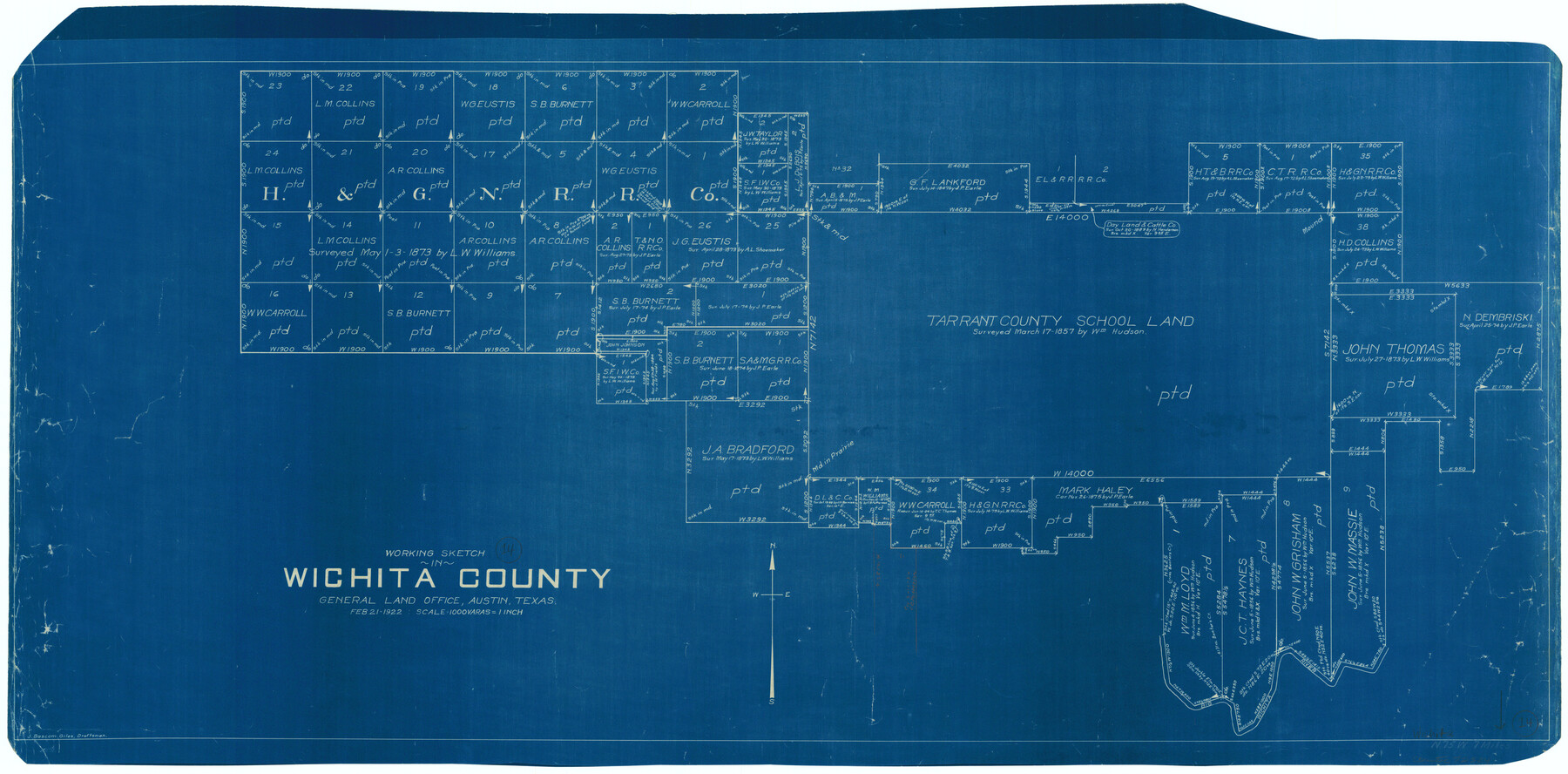
Wichita County Working Sketch 14
-
Map/Doc
72524
-
Collection
General Map Collection
-
Object Dates
2/21/1922 (Creation Date)
-
People and Organizations
J. Bascom Giles (Draftsman)
-
Counties
Wichita
-
Subjects
Surveying Working Sketch
-
Height x Width
20.8 x 42.1 inches
52.8 x 106.9 cm
-
Scale
1" = 1000 varas
Part of: General Map Collection
El Paso County Sketch File 20

Print $40.00
- Digital $50.00
El Paso County Sketch File 20
Size 31.4 x 49.4 inches
Map/Doc 10447
Flight Mission No. BRE-5P, Frame 192, Nueces County

Print $20.00
- Digital $50.00
Flight Mission No. BRE-5P, Frame 192, Nueces County
1956
Size 18.4 x 22.3 inches
Map/Doc 86838
Reagan County Rolled Sketch 27A

Print $40.00
- Digital $50.00
Reagan County Rolled Sketch 27A
1952
Size 63.7 x 47.2 inches
Map/Doc 9822
Trinity River, Owen Crossing Sheet/Elm Fork of Trinity River

Print $20.00
- Digital $50.00
Trinity River, Owen Crossing Sheet/Elm Fork of Trinity River
1914
Size 29.1 x 31.4 inches
Map/Doc 65201
Bell County Sketch File 32

Print $10.00
- Digital $50.00
Bell County Sketch File 32
1905
Size 7.6 x 8.8 inches
Map/Doc 14447
University Lands Blocks 21 to 26, Pecos County, Texas

Print $20.00
- Digital $50.00
University Lands Blocks 21 to 26, Pecos County, Texas
1939
Size 46.1 x 36.8 inches
Map/Doc 2416
Crockett County Rolled Sketch 23

Print $20.00
- Digital $50.00
Crockett County Rolled Sketch 23
1924
Size 34.2 x 26.6 inches
Map/Doc 5583
Brown County Working Sketch 20

Print $20.00
- Digital $50.00
Brown County Working Sketch 20
2011
Size 32.8 x 34.8 inches
Map/Doc 89999
Presidio County Rolled Sketch S1

Print $20.00
- Digital $50.00
Presidio County Rolled Sketch S1
Size 13.3 x 18.8 inches
Map/Doc 7414
Val Verde County Working Sketch 85

Print $20.00
- Digital $50.00
Val Verde County Working Sketch 85
1973
Size 28.5 x 38.3 inches
Map/Doc 72220
Liberty County Working Sketch 74

Print $20.00
- Digital $50.00
Liberty County Working Sketch 74
1979
Size 38.8 x 35.4 inches
Map/Doc 70534
Mosaic composed of aerial photographs - Galveston, Tex.

Print $20.00
- Digital $50.00
Mosaic composed of aerial photographs - Galveston, Tex.
1923
Size 15.3 x 33.3 inches
Map/Doc 97160
You may also like
Rockwall County

Print $20.00
- Digital $50.00
Rockwall County
1874
Size 20.3 x 18.6 inches
Map/Doc 3998
Tarrant County Rolled Sketch 2

Print $40.00
- Digital $50.00
Tarrant County Rolled Sketch 2
Size 91.5 x 13.4 inches
Map/Doc 78246
Anderson County Rolled Sketch 15

Print $20.00
- Digital $50.00
Anderson County Rolled Sketch 15
2002
Size 40.0 x 28.3 inches
Map/Doc 78315
Amarillo Improvements for Sawville-Amarillo Heights

Print $40.00
- Digital $50.00
Amarillo Improvements for Sawville-Amarillo Heights
Size 37.2 x 62.1 inches
Map/Doc 89789
Flight Mission No. DQN-2K, Frame 10, Calhoun County

Print $20.00
- Digital $50.00
Flight Mission No. DQN-2K, Frame 10, Calhoun County
1953
Size 18.5 x 22.0 inches
Map/Doc 84227
Potter County Sketch File 18

Print $20.00
- Digital $50.00
Potter County Sketch File 18
Size 34.3 x 43.4 inches
Map/Doc 10577
Jones County Sketch File 19

Print $56.00
- Digital $50.00
Jones County Sketch File 19
1875
Size 11.1 x 8.6 inches
Map/Doc 28516
[Northeast Portion of Moore County]
![91517, [Northeast Portion of Moore County], Twichell Survey Records](https://historictexasmaps.com/wmedia_w700/maps/91517-1.tif.jpg)
Print $20.00
- Digital $50.00
[Northeast Portion of Moore County]
Size 31.7 x 8.5 inches
Map/Doc 91517
Outer Continental Shelf Leasing Maps (Louisiana Offshore Operations)

Print $20.00
- Digital $50.00
Outer Continental Shelf Leasing Maps (Louisiana Offshore Operations)
1954
Size 25.5 x 15.3 inches
Map/Doc 76093
Runnels County

Print $40.00
- Digital $50.00
Runnels County
1948
Size 49.4 x 38.7 inches
Map/Doc 63010
Presidio County Rolled Sketch WR

Print $20.00
- Digital $50.00
Presidio County Rolled Sketch WR
1927
Size 35.5 x 33.2 inches
Map/Doc 7420
Webb County Sketch File 14b

Print $4.00
- Digital $50.00
Webb County Sketch File 14b
1897
Size 11.2 x 8.8 inches
Map/Doc 39812