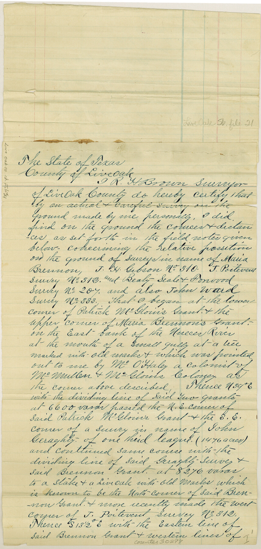
Live Oak County Sketch File 21
Sketch Around the B. Haughty Survey, Live Oak County, Texas
-
Map/Doc
30297
-
Collection
General Map Collection
-
Object Dates
4/15/1912 (Creation Date)
4/15/1912 (File Date)
-
People and Organizations
S.C. Clark (Surveyor/Engineer)
R.H. Brown (Surveyor/Engineer)
-
Counties
Live Oak
-
Subjects
Surveying Sketch File
-
Height x Width
16.8 x 8.0 inches
42.7 x 20.3 cm
-
Medium
paper, manuscript
-
Features
Nueces River
Part of: General Map Collection
[Galveston, Harrisburg & San Antonio Railway]
![64402, [Galveston, Harrisburg & San Antonio Railway], General Map Collection](https://historictexasmaps.com/wmedia_w700/maps/64402.tif.jpg)
Print $20.00
- Digital $50.00
[Galveston, Harrisburg & San Antonio Railway]
1892
Size 13.5 x 33.7 inches
Map/Doc 64402
Limestone County Working Sketch 22

Print $40.00
- Digital $50.00
Limestone County Working Sketch 22
1980
Size 43.3 x 60.2 inches
Map/Doc 70572
Reeves County Rolled Sketch 8

Print $40.00
- Digital $50.00
Reeves County Rolled Sketch 8
Size 22.6 x 64.6 inches
Map/Doc 9848
Flight Mission No. DCL-5C, Frame 78, Kenedy County

Print $20.00
- Digital $50.00
Flight Mission No. DCL-5C, Frame 78, Kenedy County
1943
Size 18.7 x 22.5 inches
Map/Doc 85861
Jefferson County Rolled Sketch 61C

Print $20.00
- Digital $50.00
Jefferson County Rolled Sketch 61C
1928
Size 27.2 x 40.3 inches
Map/Doc 6412
Cooke County Sketch File 38 1/2

Print $20.00
- Digital $50.00
Cooke County Sketch File 38 1/2
Size 21.5 x 16.6 inches
Map/Doc 11175
[Surveys in Hopkins and Wood Counties]
![365, [Surveys in Hopkins and Wood Counties], General Map Collection](https://historictexasmaps.com/wmedia_w700/maps/365-1.tif.jpg)
Print $20.00
- Digital $50.00
[Surveys in Hopkins and Wood Counties]
1838
Size 24.7 x 31.7 inches
Map/Doc 365
Galveston County NRC Article 33.136 Sketch 68

Print $34.00
- Digital $50.00
Galveston County NRC Article 33.136 Sketch 68
2008
Size 24.0 x 36.0 inches
Map/Doc 94840
Leon County Sketch File 37

Print $90.00
- Digital $50.00
Leon County Sketch File 37
1965
Size 11.2 x 8.8 inches
Map/Doc 29853
Medina County Sketch File 6

Print $22.00
- Digital $50.00
Medina County Sketch File 6
1874
Size 8.4 x 12.0 inches
Map/Doc 31454
San Augustine County Working Sketch 17

Print $20.00
- Digital $50.00
San Augustine County Working Sketch 17
1963
Size 20.3 x 21.5 inches
Map/Doc 63705
Cooke County Rolled Sketch 5

Print $20.00
- Digital $50.00
Cooke County Rolled Sketch 5
1980
Size 18.2 x 24.0 inches
Map/Doc 5563
You may also like
Harris County Sketch File 19

Print $4.00
- Digital $50.00
Harris County Sketch File 19
1862
Size 8.7 x 13.9 inches
Map/Doc 25366
Matagorda County Working Sketch 1

Print $20.00
- Digital $50.00
Matagorda County Working Sketch 1
Size 24.1 x 17.1 inches
Map/Doc 70859
Cottle County

Print $20.00
- Digital $50.00
Cottle County
1908
Size 43.9 x 39.0 inches
Map/Doc 66788
Jefferson County Rolled Sketch 48

Print $20.00
- Digital $50.00
Jefferson County Rolled Sketch 48
1963
Size 28.3 x 34.8 inches
Map/Doc 6403
Crockett County Rolled Sketch 23

Print $20.00
- Digital $50.00
Crockett County Rolled Sketch 23
1924
Size 34.2 x 26.6 inches
Map/Doc 5583
[T. & P. Block U and H. & T. C. Block 1]
![91871, [T. & P. Block U and H. & T. C. Block 1], Twichell Survey Records](https://historictexasmaps.com/wmedia_w700/maps/91871-1.tif.jpg)
Print $20.00
- Digital $50.00
[T. & P. Block U and H. & T. C. Block 1]
Size 20.5 x 16.7 inches
Map/Doc 91871

[Brown County]
![3337, [Brown County], General Map Collection](https://historictexasmaps.com/wmedia_w700/maps/3337-1.tif.jpg)
Print $20.00
- Digital $50.00
[Brown County]
1863
Size 25.4 x 22.5 inches
Map/Doc 3337
Harris County NRC Article 33.136 Sketch 19

Print $50.00
- Digital $50.00
Harris County NRC Article 33.136 Sketch 19
2014
Size 24.6 x 36.6 inches
Map/Doc 95334
Crockett County Rolled Sketch 45

Print $40.00
- Digital $50.00
Crockett County Rolled Sketch 45
Size 54.8 x 16.5 inches
Map/Doc 8710
[Surveys in Liberty County]
![69750, [Surveys in Liberty County], General Map Collection](https://historictexasmaps.com/wmedia_w700/maps/69750.tif.jpg)
Print $2.00
- Digital $50.00
[Surveys in Liberty County]
Size 5.8 x 9.3 inches
Map/Doc 69750
Hutchinson County Working Sketch 40

Print $20.00
- Digital $50.00
Hutchinson County Working Sketch 40
1978
Size 27.0 x 22.4 inches
Map/Doc 66400