Morris County Rolled Sketch 2A
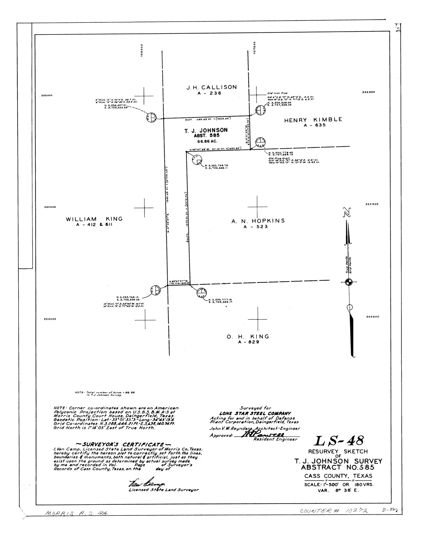
LS-48 - Resurvey sketch of T.J. Johnson survey, abstract no. 585, Cass County, Texas
-
Map/Doc
10272
-
Collection
General Map Collection
-
People and Organizations
Van Camp (Surveyor/Engineer)
-
Counties
Cass
-
Subjects
Surveying Rolled Sketch
-
Height x Width
24.0 x 18.7 inches
61.0 x 47.5 cm
-
Medium
linen, manuscript
-
Scale
1" = 180 varas
-
Comments
See Morris County Rolled Sketch 2 (9550) for map of all retracement surveys made for Lone Star Steel Company.
Related maps
Morris County Rolled Sketch 2

Print $40.00
- Digital $50.00
Morris County Rolled Sketch 2
1944
Size 59.4 x 43.5 inches
Map/Doc 9550
Part of: General Map Collection
Map of the Survey of the Parallel 36 1/2 Degrees North Latitude, Commencing at the 100th and Running to the 103rd Degree of Longitude West of Greenwich
Print $40.00
- Digital $50.00
Map of the Survey of the Parallel 36 1/2 Degrees North Latitude, Commencing at the 100th and Running to the 103rd Degree of Longitude West of Greenwich
1862
Size 115.6 x 14.9 inches
Map/Doc 73566
Webb County Working Sketch 11

Print $20.00
- Digital $50.00
Webb County Working Sketch 11
1921
Size 17.8 x 16.3 inches
Map/Doc 72376
Bee County Boundary File 8

Print $52.00
- Digital $50.00
Bee County Boundary File 8
Size 9.2 x 7.8 inches
Map/Doc 50464

Bowie County Working Sketch 9

Print $20.00
- Digital $50.00
Bowie County Working Sketch 9
1956
Size 33.1 x 36.5 inches
Map/Doc 67413
Terrell County Sketch File 1

Print $78.00
- Digital $50.00
Terrell County Sketch File 1
1881
Size 9.1 x 8.8 inches
Map/Doc 37870
Brewster County Rolled Sketch 112

Print $20.00
- Digital $50.00
Brewster County Rolled Sketch 112
1962
Size 28.9 x 25.7 inches
Map/Doc 5263
[Map of Nacogdoches County]
![93369, [Map of Nacogdoches County], General Map Collection](https://historictexasmaps.com/wmedia_w700/maps/93369-1.tif.jpg)
Print $40.00
- Digital $50.00
[Map of Nacogdoches County]
1840
Size 79.3 x 36.8 inches
Map/Doc 93369
Brewster County Sketch File N-31

Print $2.00
- Digital $50.00
Brewster County Sketch File N-31
1969
Size 12.9 x 9.0 inches
Map/Doc 15711
Jefferson County Sketch File 32

Print $4.00
- Digital $50.00
Jefferson County Sketch File 32
1900
Size 11.3 x 8.7 inches
Map/Doc 28195
Wichita County Working Sketch 14

Print $20.00
- Digital $50.00
Wichita County Working Sketch 14
1922
Size 20.8 x 42.1 inches
Map/Doc 72524
Archer County Sketch File 3

Print $4.00
- Digital $50.00
Archer County Sketch File 3
Size 7.5 x 8.5 inches
Map/Doc 13628
You may also like
Briscoe County Rolled Sketch 6

Print $20.00
- Digital $50.00
Briscoe County Rolled Sketch 6
Size 27.0 x 31.4 inches
Map/Doc 5326
Caldwell County Working Sketch 7

Print $20.00
- Digital $50.00
Caldwell County Working Sketch 7
1958
Size 29.7 x 37.2 inches
Map/Doc 67837
Map of Texas and Pacific Ry. Company's Surveys in the 80 Mile Reserve

Print $20.00
- Digital $50.00
Map of Texas and Pacific Ry. Company's Surveys in the 80 Mile Reserve
1885
Size 44.0 x 46.6 inches
Map/Doc 83558
Flight Mission No. CRC-3R, Frame 204, Chambers County

Print $20.00
- Digital $50.00
Flight Mission No. CRC-3R, Frame 204, Chambers County
1956
Size 18.6 x 22.4 inches
Map/Doc 84859
Crockett County Sketch File 46

Print $20.00
- Digital $50.00
Crockett County Sketch File 46
Size 11.1 x 8.7 inches
Map/Doc 19779
Edwards County Working Sketch 6

Print $40.00
- Digital $50.00
Edwards County Working Sketch 6
1918
Size 32.8 x 79.6 inches
Map/Doc 68882
San Augustine County Working Sketch 4

Print $20.00
- Digital $50.00
San Augustine County Working Sketch 4
1934
Size 24.4 x 27.7 inches
Map/Doc 63691
Wise County Working Sketch 31

Print $20.00
- Digital $50.00
Wise County Working Sketch 31
2009
Size 27.9 x 37.5 inches
Map/Doc 89985
[T. & P. RR. Lands and Surrounding surveys]
![91131, [T. & P. RR. Lands and Surrounding surveys], Twichell Survey Records](https://historictexasmaps.com/wmedia_w700/maps/91131.tif.jpg)
Print $20.00
- Digital $50.00
[T. & P. RR. Lands and Surrounding surveys]
1900
Size 16.4 x 12.2 inches
Map/Doc 91131
Hudspeth County Rolled Sketch 65

Print $40.00
- Digital $50.00
Hudspeth County Rolled Sketch 65
1988
Size 70.5 x 37.7 inches
Map/Doc 9229
Texas & Pacific R. R. through Pecos-Presidio Counties

Print $40.00
- Digital $50.00
Texas & Pacific R. R. through Pecos-Presidio Counties
Size 20.3 x 70.7 inches
Map/Doc 64282
Presidio County Sketch File 120

Print $16.00
- Digital $50.00
Presidio County Sketch File 120
Size 14.2 x 8.8 inches
Map/Doc 34934