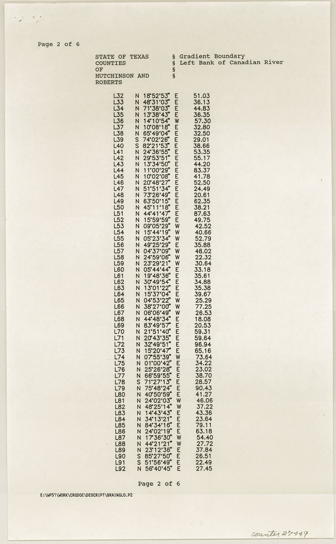
Hutchinson County Sketch File 52
[Field notes of survey of gradient boundary along the left bank of a portion of the Canadian River]
-
Map/Doc
27449
-
Collection
General Map Collection
-
Object Dates
10/22/1992 (Creation Date)
2/17/2000 (File Date)
9/8/1992 (Survey Date)
10/22/1992 (Survey Date)
-
People and Organizations
Wm. C. Wilson, Jr. (Surveyor/Engineer)
-
Counties
Hutchinson Roberts
-
Subjects
Surveying Sketch File
-
Height x Width
14.2 x 8.8 inches
36.1 x 22.4 cm
-
Medium
paper, print
-
Comments
See Hutchinson County Rolled Sketch 43 (6311-6316).
-
Features
Canadian River
Related maps
Hutchinson County Rolled Sketch 43

Print $40.00
- Digital $50.00
Hutchinson County Rolled Sketch 43
1992
Size 38.0 x 49.4 inches
Map/Doc 6311
Hutchinson County Rolled Sketch 43

Print $40.00
- Digital $50.00
Hutchinson County Rolled Sketch 43
1992
Size 40.5 x 49.4 inches
Map/Doc 6312
Hutchinson County Rolled Sketch 43

Print $40.00
- Digital $50.00
Hutchinson County Rolled Sketch 43
1992
Size 40.4 x 49.4 inches
Map/Doc 6313
Hutchinson County Rolled Sketch 43

Print $40.00
- Digital $50.00
Hutchinson County Rolled Sketch 43
1992
Size 41.3 x 50.0 inches
Map/Doc 6314
Hutchinson County Rolled Sketch 43

Print $40.00
- Digital $50.00
Hutchinson County Rolled Sketch 43
1992
Size 40.6 x 49.9 inches
Map/Doc 6315
Hutchinson County Rolled Sketch 43

Print $40.00
- Digital $50.00
Hutchinson County Rolled Sketch 43
1992
Size 40.5 x 49.4 inches
Map/Doc 6316
Part of: General Map Collection
Burnet County Boundary File 12a

Print $8.00
- Digital $50.00
Burnet County Boundary File 12a
Size 12.9 x 8.7 inches
Map/Doc 50956
Dawson County Sketch File 12

Print $20.00
- Digital $50.00
Dawson County Sketch File 12
Size 21.9 x 20.7 inches
Map/Doc 11294
Wichita County Sketch File A

Print $4.00
- Digital $50.00
Wichita County Sketch File A
1861
Size 7.8 x 10.3 inches
Map/Doc 40036
Flight Mission No. BRE-2G, Frame 118, Nueces County

Print $20.00
- Digital $50.00
Flight Mission No. BRE-2G, Frame 118, Nueces County
1950
Size 18.4 x 18.2 inches
Map/Doc 86623
Coryell County Boundary File 2

Print $4.00
- Digital $50.00
Coryell County Boundary File 2
Size 5.6 x 8.2 inches
Map/Doc 51905
Coryell County Working Sketch 15

Print $20.00
- Digital $50.00
Coryell County Working Sketch 15
1957
Size 24.3 x 20.8 inches
Map/Doc 68222
Armstrong County

Print $20.00
- Digital $50.00
Armstrong County
1933
Size 39.3 x 39.4 inches
Map/Doc 77203
Map of Nacogdoches County

Print $20.00
- Digital $50.00
Map of Nacogdoches County
1881
Size 24.5 x 21.5 inches
Map/Doc 4600
San Jacinto County Working Sketch 40

Print $40.00
- Digital $50.00
San Jacinto County Working Sketch 40
1971
Size 43.9 x 59.8 inches
Map/Doc 63753
Red River County Working Sketch 33

Print $20.00
- Digital $50.00
Red River County Working Sketch 33
1963
Size 47.0 x 22.2 inches
Map/Doc 72016
Pecos County Working Sketch 86

Print $20.00
- Digital $50.00
Pecos County Working Sketch 86
1962
Size 39.0 x 32.7 inches
Map/Doc 71558
Hutchinson County Working Sketch 41

Print $20.00
- Digital $50.00
Hutchinson County Working Sketch 41
1978
Size 26.8 x 22.3 inches
Map/Doc 66401
You may also like

Dimmit County Sketch File 45

Print $20.00
- Digital $50.00
Dimmit County Sketch File 45
1905
Size 24.9 x 25.5 inches
Map/Doc 11355
United States - Gulf Coast - Aransas Pass and Corpus Christi Bay with the coast to latitude 27° 12' Texas

Print $20.00
- Digital $50.00
United States - Gulf Coast - Aransas Pass and Corpus Christi Bay with the coast to latitude 27° 12' Texas
1913
Size 27.6 x 18.2 inches
Map/Doc 72793
General Highway Map, Hale County, Texas

Print $20.00
General Highway Map, Hale County, Texas
1961
Size 24.7 x 18.2 inches
Map/Doc 79493
Dimmit County Sketch File 28

Print $40.00
- Digital $50.00
Dimmit County Sketch File 28
Size 14.7 x 17.4 inches
Map/Doc 11350
Montague County Working Sketch 8

Print $20.00
- Digital $50.00
Montague County Working Sketch 8
1928
Size 20.9 x 18.9 inches
Map/Doc 71074
Map of Texas in 1830 Showing Spanish Colonies

Print $20.00
- Digital $50.00
Map of Texas in 1830 Showing Spanish Colonies
Size 41.1 x 42.0 inches
Map/Doc 73588
General Highway Map, Mason County, Texas

Print $20.00
General Highway Map, Mason County, Texas
1940
Size 18.2 x 24.5 inches
Map/Doc 79186
Newton County

Print $40.00
- Digital $50.00
Newton County
1946
Size 48.7 x 41.9 inches
Map/Doc 66953
Flight Mission No. DQN-6K, Frame 9, Calhoun County

Print $20.00
- Digital $50.00
Flight Mission No. DQN-6K, Frame 9, Calhoun County
1953
Size 18.5 x 22.1 inches
Map/Doc 84431
Map of the City of Aransas Pass

Print $20.00
- Digital $50.00
Map of the City of Aransas Pass
1905
Size 28.3 x 21.4 inches
Map/Doc 97266
Jefferson County Rolled Sketch 44

Print $20.00
- Digital $50.00
Jefferson County Rolled Sketch 44
1957
Size 26.9 x 25.5 inches
Map/Doc 6401