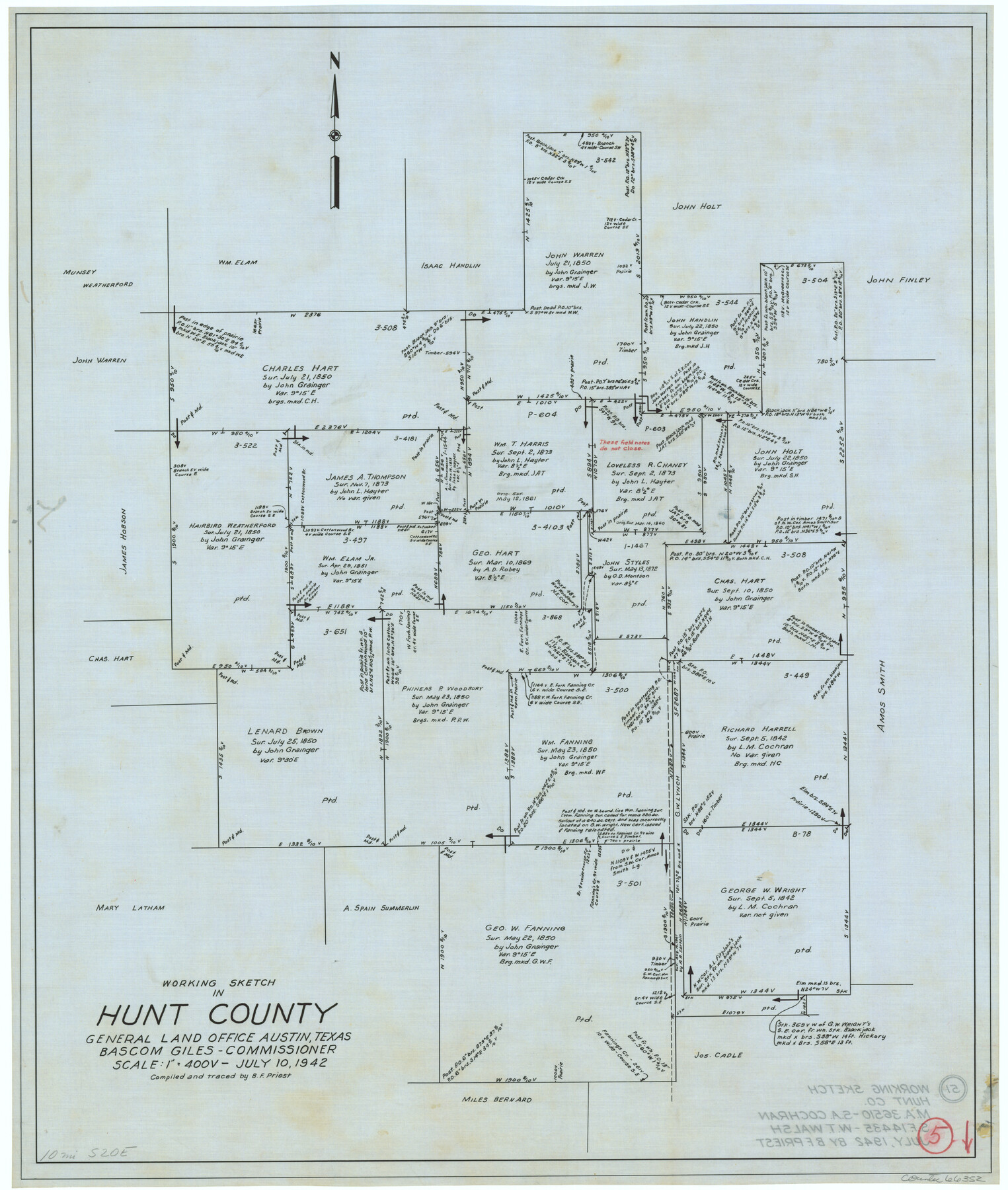
Hunt County Working Sketch 5
-
Map/Doc
66352
-
Collection
General Map Collection
-
Object Dates
7/10/1942 (Creation Date)
-
People and Organizations
B.F. Priest (Draftsman)
-
Counties
Hunt
-
Subjects
Surveying Working Sketch
-
Height x Width
23.8 x 20.2 inches
60.5 x 51.3 cm
-
Scale
1" = 400 varas
Part of: General Map Collection
Childress County Working Sketch Graphic Index

Print $20.00
- Digital $50.00
Childress County Working Sketch Graphic Index
1978
Size 45.5 x 34.3 inches
Map/Doc 76493
El Paso County Boundary File 12

Print $16.00
- Digital $50.00
El Paso County Boundary File 12
Size 13.9 x 8.5 inches
Map/Doc 53153
Amistad International Reservoir on Rio Grande 71a

Print $20.00
- Digital $50.00
Amistad International Reservoir on Rio Grande 71a
1949
Size 28.4 x 39.6 inches
Map/Doc 73359
Henderson County Boundary File 43

Print $28.00
- Digital $50.00
Henderson County Boundary File 43
Size 5.0 x 8.3 inches
Map/Doc 54708
Montgomery County Working Sketch 49

Print $20.00
- Digital $50.00
Montgomery County Working Sketch 49
1959
Size 13.8 x 12.0 inches
Map/Doc 71156
Map of section no. 9 of a survey of Padre Island made for the Office of the Attorney General of the State of Texas

Print $40.00
- Digital $50.00
Map of section no. 9 of a survey of Padre Island made for the Office of the Attorney General of the State of Texas
1941
Size 58.3 x 42.5 inches
Map/Doc 2265
Randall County Rolled Sketch 3

Print $20.00
- Digital $50.00
Randall County Rolled Sketch 3
Size 22.0 x 24.9 inches
Map/Doc 7423
Foard County Sketch File 31

Print $6.00
- Digital $50.00
Foard County Sketch File 31
1945
Size 14.5 x 9.1 inches
Map/Doc 22861
Bexar County Working Sketch 17

Print $20.00
- Digital $50.00
Bexar County Working Sketch 17
1978
Size 22.8 x 34.2 inches
Map/Doc 67333
Caldwell County Working Sketch 6

Print $20.00
- Digital $50.00
Caldwell County Working Sketch 6
1958
Size 21.8 x 26.3 inches
Map/Doc 67836
Gregg County Sketch File 2

Print $26.00
- Digital $50.00
Gregg County Sketch File 2
1921
Size 14.2 x 8.7 inches
Map/Doc 24553
Flight Mission No. CGI-4N, Frame 190, Cameron County

Print $20.00
- Digital $50.00
Flight Mission No. CGI-4N, Frame 190, Cameron County
1955
Size 18.5 x 22.2 inches
Map/Doc 84693
You may also like
Hutchinson County Rolled Sketch 40

Print $20.00
- Digital $50.00
Hutchinson County Rolled Sketch 40
1981
Size 26.8 x 37.6 inches
Map/Doc 6301
Dawson County Working Sketch 17

Print $20.00
- Digital $50.00
Dawson County Working Sketch 17
1961
Size 33.3 x 29.9 inches
Map/Doc 68561
Flight Mission No. CUG-1P, Frame 85, Kleberg County

Print $20.00
- Digital $50.00
Flight Mission No. CUG-1P, Frame 85, Kleberg County
1956
Size 18.6 x 22.2 inches
Map/Doc 86150
Sabine County Working Sketch 4

Print $20.00
- Digital $50.00
Sabine County Working Sketch 4
1913
Size 23.7 x 32.0 inches
Map/Doc 63675
Presidio County Sketch File 75

Print $30.00
- Digital $50.00
Presidio County Sketch File 75
1946
Size 8.9 x 14.3 inches
Map/Doc 34691
Presidio County Rolled Sketch 79

Print $20.00
- Digital $50.00
Presidio County Rolled Sketch 79
Size 22.2 x 27.0 inches
Map/Doc 7365
Rusk County Sketch File 30

Print $10.00
Rusk County Sketch File 30
1949
Size 11.3 x 8.9 inches
Map/Doc 35558
Van Zandt County Sketch File 34

Print $4.00
- Digital $50.00
Van Zandt County Sketch File 34
1861
Size 7.8 x 15.0 inches
Map/Doc 39472
Sheet 4 copied from Champlin Book 5 [Strip Map showing T. & P. connecting lines]
![93181, Sheet 4 copied from Champlin Book 5 [Strip Map showing T. & P. connecting lines], Twichell Survey Records](https://historictexasmaps.com/wmedia_w700/maps/93181-1.tif.jpg)
Print $40.00
- Digital $50.00
Sheet 4 copied from Champlin Book 5 [Strip Map showing T. & P. connecting lines]
1909
Size 8.0 x 75.7 inches
Map/Doc 93181

Culberson County Working Sketch 34

Print $20.00
- Digital $50.00
Culberson County Working Sketch 34
1962
Size 35.2 x 26.0 inches
Map/Doc 68487
