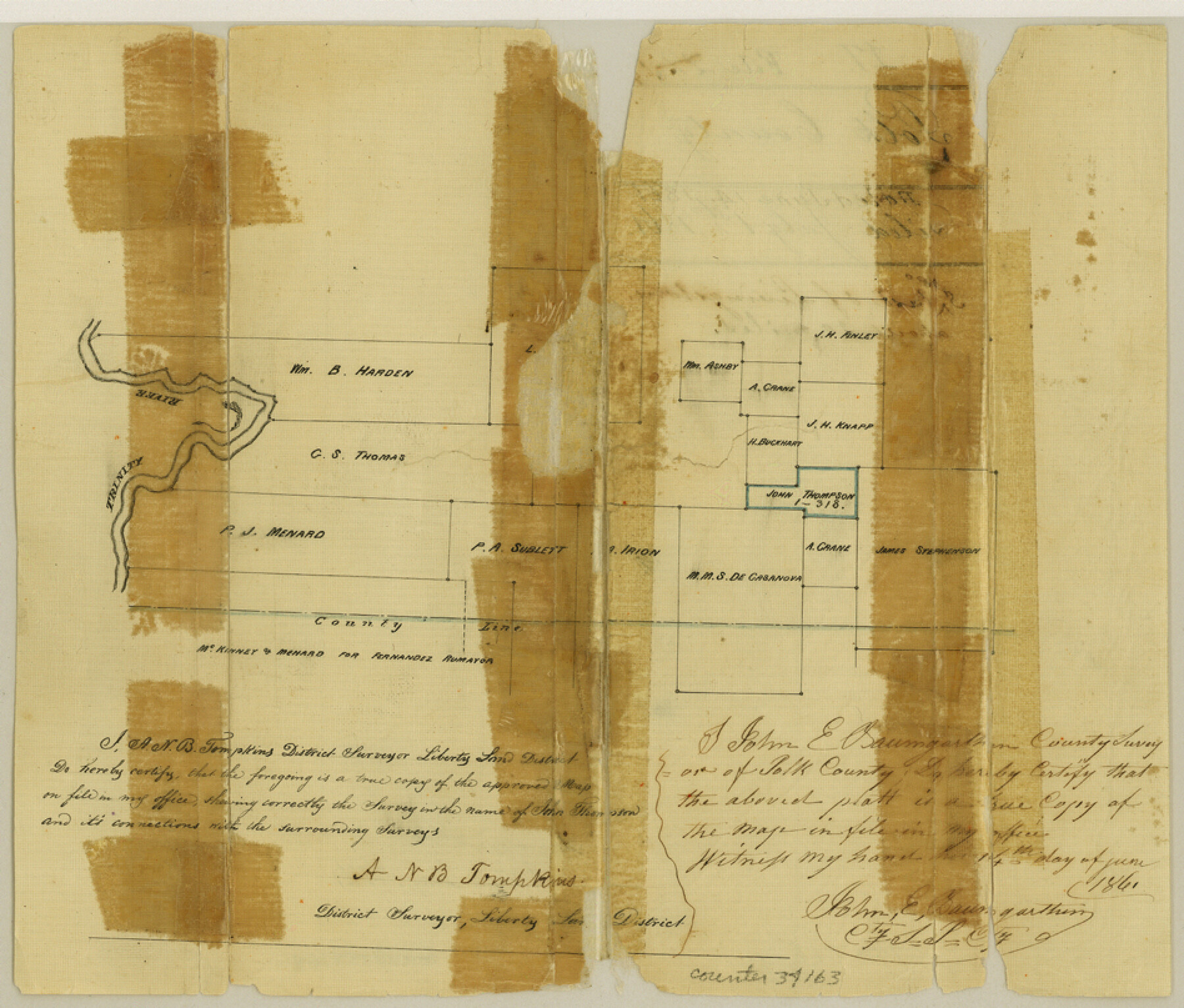
Polk County Sketch File 17
[Sketch southeast of Livingston]
-
Map/Doc
34163
-
Collection
General Map Collection
-
Object Dates
6/14/1861 (Creation Date)
7/1/1861 (File Date)
-
People and Organizations
John E. Baumgarten (Surveyor/Engineer)
-
Counties
Polk Hardin Liberty
-
Subjects
Surveying Sketch File
-
Height x Width
8.1 x 9.5 inches
20.6 x 24.1 cm
-
Medium
paper, manuscript
-
Features
Trinity River
Part of: General Map Collection
Nueces County Aerial Photograph Index Sheet 6

Print $20.00
- Digital $50.00
Nueces County Aerial Photograph Index Sheet 6
1956
Size 23.4 x 19.2 inches
Map/Doc 83739
Hill County Working Sketch 3

Print $20.00
- Digital $50.00
Hill County Working Sketch 3
1948
Size 22.7 x 19.5 inches
Map/Doc 66189
Uvalde County Sketch File 13

Print $20.00
- Digital $50.00
Uvalde County Sketch File 13
Size 14.3 x 29.1 inches
Map/Doc 12528
Howard County Working Sketch 8

Print $20.00
- Digital $50.00
Howard County Working Sketch 8
1956
Size 25.3 x 31.3 inches
Map/Doc 66275
Galveston County NRC Article 33.136 Sketch 99

Print $26.00
Galveston County NRC Article 33.136 Sketch 99
2024
Map/Doc 97422
Intracoastal Waterway - Galveston Bay to West Bay including Galveston Bay Entrance

Print $20.00
- Digital $50.00
Intracoastal Waterway - Galveston Bay to West Bay including Galveston Bay Entrance
1961
Size 26.7 x 38.7 inches
Map/Doc 69934
Fisher County Rolled Sketch 4A

Print $20.00
- Digital $50.00
Fisher County Rolled Sketch 4A
1951
Size 31.0 x 36.6 inches
Map/Doc 8889
Flight Mission No. DQN-2K, Frame 188, Calhoun County

Print $20.00
- Digital $50.00
Flight Mission No. DQN-2K, Frame 188, Calhoun County
1953
Size 18.6 x 22.3 inches
Map/Doc 84329
Kleberg County Aerial Photograph Index Sheet 7

Print $20.00
- Digital $50.00
Kleberg County Aerial Photograph Index Sheet 7
1956
Size 24.0 x 20.1 inches
Map/Doc 83724
Right of Way and Track Map Houston & Texas Central R.R. operated by the T. & N.O. R.R. Co., Austin Branch

Print $40.00
- Digital $50.00
Right of Way and Track Map Houston & Texas Central R.R. operated by the T. & N.O. R.R. Co., Austin Branch
1918
Size 25.8 x 57.8 inches
Map/Doc 64558
Flight Mission No. DCL-7C, Frame 119, Kenedy County

Print $20.00
- Digital $50.00
Flight Mission No. DCL-7C, Frame 119, Kenedy County
1943
Size 18.5 x 22.3 inches
Map/Doc 86084
Duval County Sketch File 85

Print $27.00
- Digital $50.00
Duval County Sketch File 85
1935
Size 14.3 x 9.1 inches
Map/Doc 21534
You may also like
General Highway Map, El Paso County, Texas

Print $20.00
General Highway Map, El Paso County, Texas
1961
Size 18.4 x 24.6 inches
Map/Doc 79455
Dimmit County Sketch File 20a

Print $2.00
- Digital $50.00
Dimmit County Sketch File 20a
Size 9.3 x 4.3 inches
Map/Doc 21103
[The S.K. Ry. of Texas, State Line to Pecos, Reeves Co., Texas]
![64161, [The S.K. Ry. of Texas, State Line to Pecos, Reeves Co., Texas], General Map Collection](https://historictexasmaps.com/wmedia_w700/maps/64161.tif.jpg)
Print $40.00
- Digital $50.00
[The S.K. Ry. of Texas, State Line to Pecos, Reeves Co., Texas]
1910
Size 19.2 x 120.9 inches
Map/Doc 64161
Reeves County Working Sketch 52

Print $40.00
- Digital $50.00
Reeves County Working Sketch 52
1977
Size 60.3 x 41.9 inches
Map/Doc 63495
Location of the Southern Kansas Railway of Texas through Hemphill County, Texas

Print $40.00
- Digital $50.00
Location of the Southern Kansas Railway of Texas through Hemphill County, Texas
1887
Size 20.2 x 91.8 inches
Map/Doc 64000
Hansford County Working Sketch 5

Print $20.00
- Digital $50.00
Hansford County Working Sketch 5
1967
Size 30.2 x 28.3 inches
Map/Doc 63377
[Maps of surveys in Reeves & Culberson Cos]
![61148, [Maps of surveys in Reeves & Culberson Cos], General Map Collection](https://historictexasmaps.com/wmedia_w700/maps/61148.tif.jpg)
Print $20.00
- Digital $50.00
[Maps of surveys in Reeves & Culberson Cos]
1937
Size 30.7 x 24.9 inches
Map/Doc 61148
Stephens County Working Sketch 21

Print $20.00
- Digital $50.00
Stephens County Working Sketch 21
1975
Size 34.7 x 31.9 inches
Map/Doc 63964
Flight Mission No. DQO-3K, Frame 35, Galveston County

Print $20.00
- Digital $50.00
Flight Mission No. DQO-3K, Frame 35, Galveston County
1952
Size 18.8 x 22.5 inches
Map/Doc 85076
Fannin County Working Sketch 6

Print $20.00
- Digital $50.00
Fannin County Working Sketch 6
1939
Size 11.4 x 18.0 inches
Map/Doc 69160
Webb County Working Sketch 86

Print $20.00
- Digital $50.00
Webb County Working Sketch 86
1981
Size 44.3 x 37.0 inches
Map/Doc 72453
McMullen County Working Sketch 27

Print $40.00
- Digital $50.00
McMullen County Working Sketch 27
1953
Size 53.2 x 32.9 inches
Map/Doc 70728